Buckden Pike and Hubberholme from Buckden
Yorkshire Dales Walk
Nat Park - Yorkshire Dales - Upper Wharfedale
County/Area - North Yorkshire
Author - Lou Johnson
Length - 8.4 miles / 13.7 km Ascent - 1850 feet / 561 metres
Time - 6 hours 0 minutes Grade - moderate
Maps 

| Ordnance Survey Explorer OL30 | Sheet Map | 1:25k | BUY |
| Anquet OS Explorer OL30 | Digital Map | 1:25k | BUY |
Walk Route Description
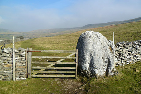
Click image to see photo description.
A Yorkshire Dales walk combining an ascent of Buckden Pike with the glorious scenery of Wharfedale. After ascending Buckden Pike the route passes through limestone scenery with views down to the River Wharfe. Reaching Scar House the walk descends to Hubberholme to follow the Dales Way back to the start.
The start is the large carpark in Buckden (Grid ref. SD942773). After parking take the gate at the northern exit signed to 'Upper Wharfedale'. Once through the gate, turn sharp right along the permissive path, initially heading south, leading to Buckden Lead Mines. After a kilometre, the path turns north to join a right of way at grid ref. SD950767 where you turn left to Buckden Lead mines. A steady ascent leads you to the mines (grid ref. SD955781).
Cross Buckden Beck and follow the path that swings north and then east beside a wall gaining height onto Buckden Pike. As the wall turns north the path heads northeast across the hillside to reach a stile. Cross this and continue to the summit with its cairn and trig point.
The decent path is the bridleway following the wall northwest. The descent soon turns southwest to reach the Buckden Rake bridleway (grid ref. SD940784). Turn right and continue to the first signed footpath on your left (grid ref. SD943790). This path descends quite steeply down a field, crossing Cray Gill to reach the road.
Take the signed path to Scar House to the right of the White Lion pub. The walking is easy with fine views into Upper Wharfedale to your left. Pass above Todd's Wood and Hubberholme Wood to reach the junction above Scar House (grid ref. SD920789). Turn sharp left and descend on the clear track into the village of Hubberholme and the church, which is well worth visiting.
Cross the River Wharfe and turn left following the Dales Way following the road to Buckden. The road walking is short lived and you turn left along a signed path to re-join the river bank for the final section back to Buckden.
Other walks nearby
| Walk 1926 | Pen-y-ghent & Littondale | hard | 16.0 miles |
| Walk 1250 | Great Whernside | moderate | 8.0 miles |
| Walk 1277 | Starbotton & Kettlewell circular | easy/mod | 5.0 miles |
| Walk 1294 | Arncliffe & Kettlewell Circular | moderate | 7.0 miles |
| Walk 1632 | Arncliffe & Starbotton from Kettlewell | moderate | 7.0 miles |
| Walk 1278 | Cosh & Foxup | easy/mod | 6.5 miles |
| Walk 2332 | Mastilles Lane & Bordley from Kilnsey | easy/mod | 6.8 miles |
| Walk 3392 | Darnbrook Fell & Fountains Fell | moderate | 6.4 miles |
| Walk 2265 | Semer Water, Stalling Busk & Marsett | easy | 4.0 miles |
| Walk 3301 | Conistone to Grassington via the Dib | easy | 5.0 miles |
Recommended Books & eBooks
Trail and Fell Running in the Yorkshire Dales
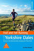 Guidebook to 40 of the best trail and fell runs in the Yorkshire Dales National Park. Ranging from 5 to 24 miles, the graded runs start from bases such as Ribblehead, Dent, Sedbergh, Malham and Grassington and take in the region's diverse delights, from castles and waterfalls to iconic mountains such as Whernside, Ingleborough and Pen Y Ghent.
More information
The Dales Way
 An essential guidebook to walking the Dales Way. This picturesque 78 mile long distance route through the Yorkshire Dales between Ilkley and Bowness on Windermere is one of the gentlest multi-day walks in Britain. The route is described in both directions, visiting Grassington, Kettlewell, Buckden, Dent, Sedbergh and Staveley en route to Bowness.
More information
Messaging & Social Media
Message Walking Britain and follow the latest news.

Mountain Weather
Stay safe on the mountains with detailed weather forecasts - for iOS devices or for Android devices.