Hardwick Hall park
Derbyshire Walk
County/Area - Derbyshire - South East Derbyshire
Author - Lou Johnson
Length - 2.5 miles / 4.1 km Ascent - 250 feet / 76 metres
Time - 1 hours 30 minutes Grade - easy
Maps 

| Ordnance Survey Explorer 269 | Sheet Map | 1:25k | BUY |
| Anquet OS Explorer 269 | Digital Map | 1:25k | BUY |
| Ordnance Survey Landranger 120 | Sheet Map | 1:50k | BUY |
| Anquet OS Landranger 120 | Digital Map | 1:50k | BUY |
Walk Route Description
Click image to visit gallery of 6 images.
This short walk offers a pleasant walk through the grounds of Hardwick Hall, which is owned by the National Trust. Located close to the M1 Motorway (Junction 29) the start for this walk is reached by a lane from Junction 29 leading to the main entrance of Hardwick Hall. Instead on turning left towards the main hall, continue down the lane and under the M1 to reach a pay and display parking area (grid ref. SK453640).
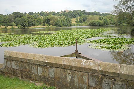
Park alongside the Miller's Pond. After parking, walk around the Pond in a clockwise direction. This will lead you to a junction of paths close to the Estate Office. Go straight across and continue around the Great Pond this time in anti-clockwise direction. You will immediately get a grand view across the Pond to Hardwick Hall and the ruins of the Old Hall. Continue on the path which closely follows the shoreline.
Once you have reached the end of the Pond the path curves to the left and passes through a gate. Turn right here and follow the edge of the trees on your right hand side. Continue until you reach a road. Turn left up the road using the grass verge for safety (this is the main exit route for cars leaving the main car park). The way ahead starts to climb and bends quite sharply left. Ahead and to you left are the ruins of the Old Hall. A little further on to your right is Hardwick Hall. You can get a good view through the gate but remember there is an admission fee.
Turn slightly back on yourself and follow the descending path at the rear of the Old Hall. To your left is a substantial wall. The route is signed "The Sculpture Walk". Descend across the park with a good view ahead over the Derbyshire countryside to reach the Row Ponds. Pass between two of these ponds and bear to the left. Continue down to the start.
Other walks nearby
| Walk 1986 | Chatsworth Park from Rowsley | easy/mod | 7.3 miles |
| Walk 2134 | Linby and Newstead Abbey circular | easy | 5.9 miles |
| Walk 1513 | Newstead Abbey from Linby | easy | 5.8 miles |
| Walk 2899 | Cromford Canal & Black Rocks from High Peak Junction | easy/mod | 6.8 miles |
| Walk 2823 | Greasley & Moorgreen Reservoir | easy | 5.9 miles |
| Walk 2218 | Cocking Tor from near Matlock | moderate | 9.5 miles |
| Walk 2627 | Cromford to Bakewell | moderate | 11.5 miles |
| Walk 1836 | The Moss Valley from Ford | moderate | 9.3 miles |
| Walk 2429 | Edwinstowe, Sherwood Forest & Major Oak circular | easy | 5.9 miles |
| Walk 2540 | The Robin Hood Way Long Distance Circular | mod/hard | 27.0 miles |
Recommended Books & eBooks
Walking in Derbyshire
 Walking guidebook to 60 circular day walks in Derbyshire and the Peak District. Includes the Derwent, Wye and Trent river valleys, near Derby, Matlock, Glossop, Bakewell and Ripley. Routes range from easy to moderate and are between 4 and 14km (2 to 10 miles). Walks focus on places of interest, from Stone Age forts to castles to grand estates.
More information
Walking in the Peak District - White Peak East
 Guidebook describing 42 half-day and day walks in the limestone landscapes of Derbyshire's White Peak, part of the Peak District National Park. One of two volumes, this book covers the east of the region, with potential bases including Bakewell, Eyam, Castleton, Birchover, Matlock and Wirksworth.
More information
Messaging & Social Media
Message Walking Britain and follow the latest news.

Mountain Weather
Stay safe on the mountains with detailed weather forecasts - for iOS devices or for Android devices.