Grange & Watendlath from Rosthwaite
Lake District Walk
Nat Park - Lake District - Lake District Central Fells
County/Area - Cumbria
Author - Lou Johnson
Length - 7.6 miles / 12.4 km Ascent - 900 feet / 273 metres
Time - 4 hours 40 minutes Grade - easy/mod
Maps 

| Ordnance Survey Explorer OL4 | Sheet Map | 1:25k | BUY |
| Anquet OS Explorer OL4 | Digital Map | 1:25k | BUY |
| Ordnance Survey Landranger 90 | Sheet Map | 1:50k | BUY |
| Anquet OS Landranger 90 | Digital Map | 1:50k | BUY |
Walk Route Description
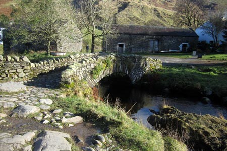
Click image to see photo description.
Combining the delights of Borrowdale with the rural charm of Watendlath, this Lake District walk offers some wonderful Lakeland views and relatively easy walking. Route finding is generally easy although there is a steady ascent from Lodore up to Watendlath.
The start is the small car park in Rosthwaite (grid ref. NY257148), which can fill early in good weather. After parking exit the car park and turn right following the Cumbria Way down the lane, bearing right at the first junction to reach the River Derwent, which initially runs parallel to the route on your left. Cross the River at the first bridge (grid ref. NY252150) and continue downstream on the path running parallel to the river on your right.
Stay alongside the river ignoring a path going left and enter pleasant woodland on with Castle Crag rising to your left. The path briefly leaves the river as it meanders north to rejoin the Derwent. The path develops into a track and continues north to reach a junction of tracks (grid ref. NY249170). Bear left here staying on the Cumbria Way passing Hollows Farm to reach another junction (grid ref. NY248175). Bear right here keeping on the Cumbria Way and continue to a tarmac lane. Bear left along the lane before turning right to continue along a track signed 'Cumbria Way'. After 500 metres, bear right onto a path leading towards Lodore. This section of the route provides some good views of Derwentwater before crossing the River Derwent and exiting on the main Borrowdale Road.
Turn left along the road for 100 metres and take the "Entrance to Waterfalls" on your right. At the time of writing there was a small charge to enter these private grounds. There are many paths which can be confusing so a good sense of direction is required. Keep climbing through the woods. Turn left away from the Lodore Falls and then right along the base of a crag. Ignore paths on your left and keep with the stream on your right. Cross a ladder stile over a wall, turn right and cross the footbridge. Turn left and follow the clear path to Watendlath.
Do not cross the packhorse bridge. Instead keep ahead to the shores of Watendlath Tarn. Bear right away from the Tarn and start to climb to Puddingstone Bank. The retrospective views of Watendlath provide an excuse for a brief stop. Continue up to the summit of the path and begin the descent down to Rosthwaite. The path is a little rough in places and continues to a junction (grid ref. NY263155) where you bear left. At the next junction bear right and you are soon back in Rosthwaite.
Other walks nearby
| Walk 1444 | Great Gable (Borrowdale route) | hard | 12.0 miles |
| Walk 3328 | Eagle Crag & Seargeant's Crag from Stonethwaite | moderate | 7.0 miles |
| Walk 3133 | Ullscarf and Watendlath from Stonethwaite | mod/hard | 10.0 miles |
| Walk 1175 | Combe Gill Circuit | moderate | 5.5 miles |
| Walk 1245 | Castle Crag & Grange | easy/mod | 6.0 miles |
| Walk 2525 | Standing Crag & Dock Tarn from Watendlath | moderate | 7.0 miles |
| Walk 2526 | Standing Crag, Ullscarf & Borrowdale | mod/hard | 10.0 miles |
| Walk 1268 | Cat Bells & High Spy | moderate | 8.0 miles |
| Walk 1065 | Haystacks | moderate | 5.5 miles |
| Walk 1112 | Great Gable | hard | 7.3 miles |
Recommended Books & eBooks
Lake District: High Level and Fell Walks
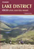 This guidebook describes 30 graded fell walks on the ridges and high peaks of the English Lake District, the UK's most popular national park. Reaching some of England's finest and highest mountain scenery, this guide leads readers to classic horseshoes and traditional ascents as well as lesser-known routes to quieter summits.
More information
Great Mountain Days in the Lake District
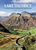 An inspirational guidebook to 50 challenging walks on the high fells of the Lake District. The graded circular routes, between 4 and 14 miles in length, cover classic Lakeland summits like Fairfield, Scafell Pike, Great Gable and Blencathra, to the lesser-known High Spy, King's How and Brund Fell.
More information
Messaging & Social Media
Message Walking Britain and follow the latest news.

Mountain Weather
Stay safe on the mountains with detailed weather forecasts - for iOS devices or for Android devices.