Montgomery Canal & River Severn near Welshpool
Powys Walk
County/Area - Powys - Powys North
Author - Lou Johnson
Length - 7.0 miles / 11.4 km Ascent - 200 feet / 61 metres
Time - 3 hours 40 minutes Grade - easy/mod
Maps 

| Ordnance Survey Explorer 240 | Sheet Map | 1:25k | BUY |
| Anquet OS Explorer 240 | Digital Map | 1:25k | BUY |
Walk Route Description
Click image to see photo description.
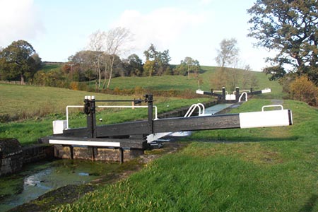
This Powys walk, located north of Welshpool off the A483, explores a section of the Montgomery Canal and follows the Offa's Dyke Path and Severn Way along the banks of the River Severn. The canal was closed for many years and is currently under restoration with the intention to reopen the full length in due course. The many years when the canal lay out of use encouraged wildlife and today the canal is an important habitat for a range of species.
The start is the car park at the Wern Claypit Nature Reserve (grid ref. SJ251140). After parking, walk south along the canal following the towpath for just under two miles. On this section you pass Bank Lock, Cabin Lock and Crowther Hall Lock to reach Bridge 111. Just after this bridge bear left following the signs to 'Powis Arms' pub (this is just before reaching Top Lock). Follow the lane to the A483 (grid ref. SJ256114).
Turn left along the A483 following the pavement. Just pat the farm buildings on your left you will reach an Offa's Dyke/Severn Way footpath sign pointing across the road to 'Four Crosses'. Cross the road, with care, cross the stile on the left and walk half right to follow the path that runs parallel to the River Severn. The way ahead follows the River Severn (on your right) and after just over a mile joins the Tirymynach Embankment (grid ref. SJ271131) which was built as flood protection.
After a mile or so following the embankment you reach a stile and adjacent metal gate (grid ref. SJ277146) with Rhyd-esgyn Lane down to your left. Turn down to the road and go left. Follow this quiet lane for a mile keeping straight ahead at two junctions. Just before a small bridge with metal railings (grid ref. SJ262151) turn left over a stile onto an embankment. There is a path of sorts and it follows the stream on your right to reach the A483 (grid ref. SJ260150).
Cross the A483 with care as traffic can be fast on this section. Bear left to the end of a metal crash barrier and locate a stile adjacent to a metal double gate. Cross the stile and continue along the embankment. Continue across an old railway formation to reach a lane (grid ref. SJ257147). Turn right, and follow the lane past Lower House Farm to reach a road junction jest before a canal bridge (grid ref. SJ254149). Turn left down the lane and immediately bear right onto the canal towpath. Continue along the canal past Burgedin Locks and bridge 106 to regain the car park used at the start of the walk.
Other walks nearby
| Walk 1876 | Breidden Hill from Middletown | moderate | 6.5 miles |
| Walk 3266 | The Dingle & Y Golfa from Welshpool | easy/mod | 6.6 miles |
| Walk 3529 | Stiperstones from Snailbeach | easy/mod | 7.0 miles |
| Walk 1871 | Snailbeach & the Stiperstones | moderate | 7.0 miles |
| Walk 2814 | Corndon Hill from Priest Weston | easy | 1.5 miles |
| Walk 1072 | Stiperstones low level circular | easy | 4.0 miles |
| Walk 1832 | The Hollies & Poles Coppice from near Habberley | easy/mod | 5.0 miles |
| Walk 1809 | Shelve & the Stiperstones from The Bog | moderate | 9.0 miles |
| Walk 2083 | Linley Hill and Linley from The Bog | moderate | 8.5 miles |
| Walk 3395 | The Stiperstones Ridge | easy/mod | 5.5 miles |
Recommended Books & eBooks
The Cambrian Way
 Guidebook to the Cambrian Way, a challenging three-week mountain trek through Wales from Cardiff to Conwy. The 470km un-waymarked route is presented from south to north. Often sticking to long, beautiful ridgelines, it crosses wild and rugged terrain and visits many of Wales's highest mountains, including Snowdon.
More information
Messaging & Social Media
Message Walking Britain and follow the latest news.

Mountain Weather
Stay safe on the mountains with detailed weather forecasts - for iOS devices or for Android devices.