Ogwen Walks and Walking Guide
Snowdonia, Gwynedd
Find circular walks near the Ogwen Valley which lies on the A5 south of Bangor. Basic amenities are available including campsites and caravan parks. Accommodation is limited and you may have to stay outside the immediate vicinity. Public transport is limited but the Snowdon Sherpa service provides excellent links for walkers during the season.
All walks are free to download and print, and all routes have mapping and GPX files. There are many highlights which include Tryfan and the Glyders, the high peaks of the Carneddau, and slightly further away a variety of routes on Snowdon including Crib Goch. Easy walks are limited and perhaps the best walk is to follow the path around Llyn Idwal which is in the heart of the mountains. Overall the Ogwen Valley provides one of the best areas in the Snowdonia National Park with a superb range of great days in the mountains.
★ = GPS file available
| Walk | Description | Grade | Miles |
|---|---|---|---|
| 2680★ | Circuit of Llyn Idwal from Ogwen Cottage | easy | 2.80 |
| 3001★ | Tryfan North Ridge from Ogwen Valley | hard | 3.50 |
| 2122★ | Cwm Glas from Pen-y-pass | mod/hard | 4.00 |
| 2855★ | Gallt yr Ogof & Braich y Ddeugwm | moderate | 4.00 |
| 1186★ | Y Garn from Ogwen Cottage | mod/hard | 4.50 |
| 1137★ | Y Garn (Route 2) from Ogwen Cottage | mod/hard | 4.50 |
| 3062★ | Pen yr Ole Wen from from Ogwen Valley | moderate | 5.00 |
| 1088★ | Glyder Ridge traverse from Ogwen Valley | hard | 5.50 |
| 1454★ | Glyder Fawr & Glyder Fach from Pen-y-Pass | mod/hard | 5.50 |
| 1215★ | Tryfan & Llyn Ogwen from Ogwen Valley | mod/hard | 5.50 |
| 3056★ | Pen yr Helgi Du from Ogwen Valley | moderate | 5.50 |
| 3026★ | Tryfan & the Eastern Tops from Ogwen Valley | hard | 5.75 |
| 3073★ | Crib Goch, Garnedd Ugain and Snowdon from Pen-y-pass | hard | 6.50 |
| 3051★ | Yr Elen from Gerlan | hard | 6.50 |
| 2417★ | Glyder Fach, Glyder Fawr and Tryfan from Idwal Cottage | mod/hard | 6.50 |
| 1958★ | The Snowdon Horseshoe from Pen-y-pass | hard | 7.50 |
| 1216★ | Y Lliwedd & Snowdon from Pen-y-pass | mod/hard | 7.50 |
| 1418★ | Snowdon and Y Lliwedd from Pen-y-pass | mod/hard | 7.50 |
| 2692★ | Snowdon via Dinas Mot & Crib Goch from Pen-y-pass | hard | 8.00 |
| 2558★ | Carnedd Dafydd & Pen yr Ole Wen from Bethesda | mod/hard | 8.00 |
| 2650★ | Tryfan, the Glyders & Y Garn from Ogwen Valley | very hard | 8.00 |
| 3019★ | Y Garn & Carnedd y Filiast Ogwen Cottage | hard | 8.50 |
| 3036★ | Snowdon via Crib Goch from Pen-y-pass | very hard | 8.50 |
| 3052★ | Yr Elen & Carnedd Dafydd from Gerlan | hard | 9.00 |
| 1150★ | The High Carneddau from Ogwen Valley | hard | 10.00 |
| 1074★ | The Glyders Traverse from Capel Curig | very hard | 12.00 |
| 2820★ | Carneddau traverse from Llyn Ogwen | mod/hard | 14.00 |
| 1232★ | Carnedd Llewelyn, Llyn Eigiau & Llyn Cowlyd | hard | 16.00 |
| 3002★ | Welsh Three-Thousanders from Pen-y-Pass | severe | 31.50 |
The walks listed above are the nearest 30 from Ogwen when measured in a straight line.
Recommended Reading
Snowdonia: 30 Low-level and easy walks - South
 Guidebook describing 30 walks in Snowdonia, Wales. Routes are mostly low level and on clear paths and showcase the region's beautiful scenery and rich history and culture. Part of a 2-volume set, this southern volume includes Trawsfynydd, Bala, Dolgellau, Machynlleth, the Harlech Coast and the valleys of the Mawddach and Dyfi.
More information
The Wales Coast Path
 A single guidebook to walking the whole Wales Coast Path - 1400km (870 miles) the length of Wales from Chester to Chepstow, including Anglesey, described in 57 stages. The route passes through the Snowdonia and Pembrokeshire National Parks and many AONBs and can be linked with the Offa's Dyke Path for a complete circuit of Wales.
More information
Further Information
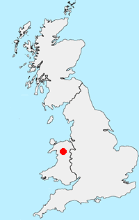
Walk Location Map
Walking in Snowdonia
Walking in TSnowdonia (Eryri) National Park is much more than the highest mountain in England and Wales. Mainly mountainous, it encompasses a large area of beautiful and often spectacular wild landscapes. Located in North Wales, the National Park offers a tremendous variety of walks with many challenging mountain routes. More Information
Walk grading - Learn how each walk is assessed and select a walk to suit your ability and experience by going to Walk Grading Details.
Messaging & Social Media
Message Walking Britain and follow the latest news.

Mountain Weather
Stay safe on the mountains with detailed weather forecasts - for iOS devices or for Android devices.