Alport Castles from Fairholme
Peak District Walk
Nat Park - Peak District - Bleaklow Longendale
County/Area - Derbyshire
Author - Lou Johnson
Length - 8.5 miles / 13.8 km Ascent - 960 feet / 291 metres
Time - 5 hours 10 minutes Grade - moderate
Maps 

| Ordnance Survey Explorer OL1 | Sheet Map | 1:25k | BUY |
| Anquet OS Explorer OL1 | Digital Map | 1:25k | BUY |
| Ordnance Survey Landranger 110 | Sheet Map | 1:50k | BUY |
| Anquet OS Landranger 110 | Digital Map | 1:50k | BUY |
Walk Route Description
Click image to visit gallery of 6 images.
The area around the Derwent valley just north of the A57 from Sheffield to Glossop offers a good starting point for many excellent walks. The starting point, Fairholme car park, is often busy and at peak times (weekends and bank holidays) the road alongside the reservoir is closed to traffic north of this point. This does have benefits as the road walking is surprisingly pleasant on traffic free days. Fairholme also offers an information centre, bike hire, a refreshment kiosk and toilets.
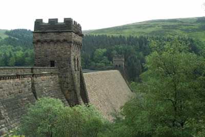
To start this Peak District walk, after parking head back to the road and walk north with the dam wall of the Derwent Reservoir on your right. Used as a practice area for the Lancaster bombers popularly known as the "Dambusters" there is a memorial to the aircrew. (There is also a small museum to the Dambusters aircrew, which is open on most weekends. There is no admission charge although donations are welcome.) Stay on the road, which offers good views across to Back Tor and Margery Hill to reach another dam which holds back the waters of Howden Reservoir.
The majority of the road walking is over and turning west you reach a sharp bend in the road where it doubles back on itself. Just before the bridge over the river turn left along a forest track. After two hundred metres turn left again to join a signed footpath that climbs steadily out of the plantation and on to the moors. Reaching open country the views improve dramatically in all directions especially to the east and north. Stay with this footpath/track to reach Alport Castles. Formed from a massive landslip the location is quite dramatic with a superb view up the valley containing the River Alport towards Bleaklow.
From Alport Castles turn south and follow the ridge path. This descends steadily to bring you to a cross-roads of paths at the western end of Hagg Side Plantation. Here you follow the southern edge of the wood for just under a kilometre to reach a fork in the path (grid ref. 171886) where you turn east and descend to the shores of Ladybower Reservoir. Rather than follow the road take the path that skirts the shore of the reservoir. This is a far more pleasant way to regain your transport at Fairholme.
Other walks nearby
| Walk 1489 | Blackden Brook, Kinder & Upper Ashop | moderate | 6.8 miles |
| Walk 3049 | Bleaklow Stones from Derwent Valley | mod/hard | 12.0 miles |
| Walk 2588 | Win Hill & Hope Cross | moderate | 7.5 miles |
| Walk 3540 | The Derwent Edge from Cutthroat Bridge | moderate | 10.0 miles |
| Walk 1286 | Castleton Great Ridge & Mam Tor | moderate | 8.5 miles |
| Walk 2599 | Kinder Scout and Castleton Ridge from Hope | mod/hard | 13.5 miles |
| Walk 1706 | Win Hill from Hope | easy/mod | 6.5 miles |
| Walk 1159 | Grindsbrook & Edale Head | moderate | 7.5 miles |
| Walk 1264 | Rushup Edge & Crowden Tower | moderate | 10.0 miles |
| Walk 1295 | Ringing Roger & Edale Cross | moderate | 10.0 miles |
Recommended Books & eBooks
Walking in the Peak District - White Peak East
 Guidebook describing 42 half-day and day walks in the limestone landscapes of Derbyshire's White Peak, part of the Peak District National Park. One of two volumes, this book covers the east of the region, with potential bases including Bakewell, Eyam, Castleton, Birchover, Matlock and Wirksworth.
More information
Walking in Derbyshire
 Walking guidebook to 60 circular day walks in Derbyshire and the Peak District. Includes the Derwent, Wye and Trent river valleys, near Derby, Matlock, Glossop, Bakewell and Ripley. Routes range from easy to moderate and are between 4 and 14km (2 to 10 miles). Walks focus on places of interest, from Stone Age forts to castles to grand estates.
More information
Messaging & Social Media
Message Walking Britain and follow the latest news.

Mountain Weather
Stay safe on the mountains with detailed weather forecasts - for iOS devices or for Android devices.