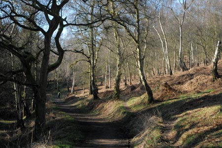
Sherbrook Valley from Punch Bowl, Milford
Cannock Chase Walk
Region - Cannock Chase
County/Area - Staffordshire - Cannock Chase
Author - Lou Johnson
Length - 4.0 miles / 6.5 km Ascent - 350 feet / 106 metres
Time - 2 hours 20 minutes Grade - easy
Maps 

| Ordnance Survey Explorer 244 | Sheet Map | 1:25k | BUY |
| Anquet OS Explorer 244 | Digital Map | 1:25k | BUY |
| Ordnance Survey Landranger 127 | Sheet Map | 1:50k | BUY |
| Anquet OS Landranger 127 | Digital Map | 1:50k | BUY |
Walk Route Description
Click image to visit gallery of 9 images.
This circular Cannock Chase walk starts from the Punch Bowl free car park located on the south side of the A513 about a mile east of Milford Common (grid ref. SJ983207). The route follows sections of the Heart of England and Staffordshire Way covering both woodland and open heathland typical of Cannock Chase. Generally route finding is relatively easy although the section on Coppice Hill can be confusing so a suitable map is useful.
After parking, walk south west along the clear rising path (Staffordshire Way) with a fence on your left. Ignore minor paths disappearing into the woodland on your right. Soon the path starts to descend to reach a junction (grid ref. SJ980202). Leave the Staffordshire which bear left and turn right along a broad path/track to reach another obvious junction (grid ref. SJ978201) after about 300 metres. On your right you will see the "German Cutting" which used to contain a railway that led up to the First World War camps that once covered Cannock Chase. Turn left here and follow the Heart of England Way as it climbs steadily through woodland. You will see Mere Pits (a pond) on your right.
Stay on the Heart of England Way following the widest of the tracks at each subsequent junction - basically keeping straight ahead. This will lead you into more a more open area and a car park (grid ref. SJ979180). Navigation here is difficult to describe as there are many paths in the vicinity of the car park. However on reaching the car park, turn left and walk about 50 metres and then turn left. Still following the Heart Of England Way. This is where the map becomes useful!
The Heart of England Way is a broad path crossing open heathland. Ahead you will see the Post Office Communication Tower and this provides a perfect landmark. To your left you can see across the Sherbrook Valley to some of the forested areas of Cannock Chase. Sadly signs are in short supply. After approximately 600m metres you will arrive at the junction with the Staffordshire Way (grid ref. SJ980184). Turn right here and descend into Sherbrook Valley.
Reaching the path/track along the valley floor (grid ref. SJ985187), turn left staying on the Staffordshire Way which is now heading north. The Sherbrook is on your right. Continue following this clear path as it follows the stream. After just over a kilometre you will reach the steeping stones across the Sherbrook. Do not cross and continue along the Staffordshire Way to reach the first junction you encountered at the start of the walk (grid ref. SJ980202). Turn right here and the car park is a short walk away.
Other walks nearby
| Walk 1189 | Cannock Chase Circular | easy | 6.5 miles |
| Walk 2911 | Seven Springs, Little Haywood, Shugborough & Milford | easy | 6.5 miles |
| Walk 2111 | Milford, Seven Springs, Little Haywood & Shugborough | easy | 6.0 miles |
| Walk 1802 | Shugborough Park from Milford | easy | 4.5 miles |
| Walk 2023 | Cannock Chase War Trail | moderate | 7.5 miles |
| Walk 1843 | Haywood Slade & Sherbrook from Seven Springs | easy | 4.0 miles |
| Walk 1753 | Abraham's Valley & Haywood Warren from Seven Springs | easy | 3.0 miles |
| Walk 2199 | Brocton & Walton-on-the-Hill Circular | easy | 3.5 miles |
| Walk 1324 | Glacial Boulder & Sherbrook | easy | 3.5 miles |
| Walk 1413 | Sherbrook, Stepping Stones & Freda's Memorial | easy | 6.0 miles |
Recommended Books & eBooks
Walking in the Peak District - White Peak East
 Guidebook describing 42 half-day and day walks in the limestone landscapes of Derbyshire's White Peak, part of the Peak District National Park. One of two volumes, this book covers the east of the region, with potential bases including Bakewell, Eyam, Castleton, Birchover, Matlock and Wirksworth.
More information
Messaging & Social Media
Message Walking Britain and follow the latest news.

Mountain Weather
Stay safe on the mountains with detailed weather forecasts - for iOS devices or for Android devices.