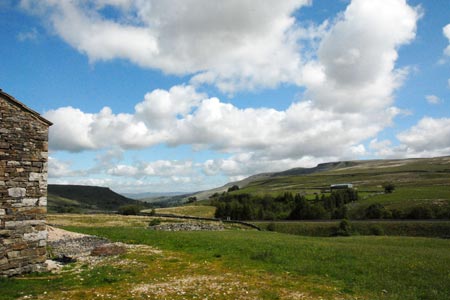
Mallerstang Edge from Aisgill Moor
Cumbria Walk
County/Area - Cumbria - Eden Valley Mallerstang
Author - Lou Johnson
Length - 8.8 miles / 14.2 km Ascent - 1300 feet / 394 metres
Time - 5 hours 40 minutes Grade - moderate
Maps 

| Ordnance Survey Explorer OL19 | Sheet Map | 1:25k | BUY |
| Anquet OS Explorer OL19 | Digital Map | 1:25k | BUY |
| Ordnance Survey Landranger 98 | Sheet Map | 1:50k | BUY |
| Anquet OS Landranger 98 | Digital Map | 1:50k | BUY |
Walk Route Description
Click image to visit gallery of 11 images.
This walk in the upper reaches of the Eden Valley ascends the escarpment lying on the east side of the valley. The route includes some pathless sections and a good sense of direction and suitable maps are recommended. There is some steep ascent involved although you are rewarded by some fine views of Mallerstang, Wild Boar Fell and the surrounding area. Notes also included on visiting two summits, Archy Styrigg and High Seat.
The start is Aisgill Moor Cottages (grid ref SD778962) where limited parking is available in the vicinity. An alternative approach is given in the final paragraph of this description. After parking leave the road and cross the railway bridge following the clear track to the first junction (grid ref. SD778965). It is worth spending a few minutes diverting to Hell Gill Force which can be very dramatic after heavy rain. Turn right here along another track and make your way up to Hellgill and beyond to the Pennine Bridleway (grid ref. SD786968).
Turn left along the Pennine Bridleway with the wall on your left. Where the wall ends and descends into the valley keep ahead to the "Water Cut" sculpture (grid ref. SD785985). This the first (or last) of a number of sculptures along the Eden Valley. The next objective is Raven's Nest (grid ref. SD794990), which lies roughly north east of the sculpture. Using a mixture of sheep trods and rough pasture the ascent proved easier than it looked picking up a clear path running along the edge.
The views from the edge are superb with Wild Boar Fell across the valley capturing your attention. Closer to hand the rocky outcrops forming the edge are impressive. Continue on the clear path which undulates above Hangingstone Scar and continues to High Loven Scar. The summit of Archy Styrigg lies to the east of the latter and can be reached by sheep trods and a path from the main path along the edge.
Continuing north along what has become a less distinct edge, you can also 'bag' the summit of High Seat, which is the highest point on this side of the Eden Valley. Describing the route is difficult but by heading east along Sloe Brae Gill and then striking off north to the summit worked well. Luckily there had been little rain in the preceding weeks so be prepared for some wet ground after rain.
To return to the start retrace your steps. Remember that if cloud descends then navigation can be problematic and careful use of maps and a compass might be necessary.
An alternative start is the small car park at grid ref. NY783004 near The Thrang. From here take Pennine Bridleway as it ascends the eastern flank of Mallerstang. This leads up to the "Water Cut" sculpture from here the description given above should be followed.
Other walks nearby
| Walk 1160 | Wild Boar Fell & Swarth Fell | moderate | 7.0 miles |
| Walk 2409 | The Upper Eden valley without a car | moderate | 12.0 miles |
| Walk 1383 | Pendragon Castle | easy | 2.3 miles |
| Walk 3573 | Wild Boar Fell from Pendragon Castle | moderate | 8.3 miles |
| Walk 1389 | Fell End Clouds | easy | 3.0 miles |
| Walk 2253 | Uldale Falls & Wandale | moderate | 8.5 miles |
| Walk 3006 | Cautley Spout & The Calf | moderate | 5.5 miles |
| Walk 1393 | Yarlside | moderate | 4.0 miles |
| Walk 1387 | Cautley Spout | easy | 2.0 miles |
| Walk 1970 | Great Knoutberry Hill & Dent Head | moderate | 9.5 miles |
Recommended Books & eBooks
Walking the Lake District Fells - Patterdale
 Part of the Walking the Lake District Fells series, this guidebook covers a wide range of routes to 35 Lakeland summits that can be climbed from Ambleside, Grasmere and Patterdale and the Thirlmere and Ullswater valleys, with highlights including Helvellyn and Fairfield. Suggestions for longer ridge routes are also included.
More information
Walking the Lake District Fells - Mardale and the Far East
 Part of the Walking the Lake District Fells series, this guidebook covers a wide range of routes to 36 Lakeland summits that can be climbed from the Ullswater, Haweswater, Troutbeck, Kentmere and Longsleddale valleys, with highlights including High Street, Place Fell and the Kentmere fells. Suggestions for longer ridge routes are also included.
More information
Messaging & Social Media
Message Walking Britain and follow the latest news.

Mountain Weather
Stay safe on the mountains with detailed weather forecasts - for iOS devices or for Android devices.