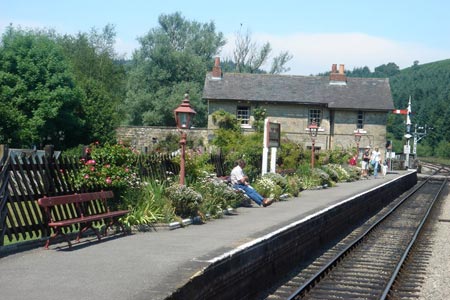
Hole of Horcum from Levisham Station
North York Moors Walk
Nat Park - North York Moors - North York Moors East
County/Area - North Yorkshire
Author - Andy Chaplin
Length - 8.5 miles / 13.8 km Ascent - 700 feet / 212 metres
Time - 5 hours 0 minutes Grade - easy/mod
Maps 

| Ordnance Survey Explorer OL27 | Sheet Map | 1:25k | BUY |
| Anquet OS Explorer OL27 | Digital Map | 1:25k | BUY |
| Ordnance Survey Landranger 101 | Sheet Map | 1:50k | BUY |
| Anquet OS Landranger 101 | Digital Map | 1:50k | BUY |
Walk Route Description
Click image to see photo description.
Apart from one climb out of North Dale from beside the North Yorks Moors Railway this is an easy circular walk on well defined paths. It offers some wonderful scenery and the chance to see steam trains in operation on the North Yorks Moors Railway,
The start of this North York Moors is Levisham Station (grid ref. 817910), which despite its name lies quite some distance west of the village of the same name. There is a £ 2 suggested donation to the NYMR for all day parking. However further back along the road at the information sign (grid ref. SE821917) there is some space for those not prepared to pay this modest charge. After parking cross the railway and take the road north-west and then north along Newton Dale past the Grange (grid ref. SE812918). The road is gated and locked at both ends so is generally very quiet for walking.
Continue along the Hardigate Road past Kale Pot Hole and Gallock Hill to Raper's Cottage. The "main" road doubles back on itself towards the gated exit at Raindale Head but keep walking north towards Newtondale Halt (grid ref. SE835948). which is a good place to sit and wait for a train to pass through at this request-stop station. Carry on north until Pifelhead Wood (on your right across the beck and tracks) ends then cross on the footbridge (grid ref. SE843953). Go through the woods and climb up at the side of Havern Beck.This climb is short and steep. There is a drop down to your right towards the beck but the path has been cut into the hillside and is easy to follow. As the path reaches the top there is a view of a small waterfall and the hairpin bend at the Hole of Horcum is visible at the end of a path that makes towards it over the moorland.
Just before reaching the road take the Tabular Hills Walk (grid ref. SE849940) west then south west on an estate track that passes barrows at the start of the track and then gives good views into the Hole of Horcum. The track then crosses Levisham Moor to Dundale Pond (grid ref. SE826918) where there is a 5-fingered post which directs you westwards towards Levisham station. Shortly afterwards continue straight ahead at the next signpost and after you leave the wall, which has been on your left hand side, take the path on your left down the side of the hill towards the road leading back to Levisham station.
The path cuts off the corner of the road (if you didn't park there) then continues down via the road to the station parking where there are not only trains but also toilets and a refreshment kiosk. What's not to like? The nearby Horseshoe Inn at Levisham is walker-friendly although you will be required to leave you boots at the door before sampling the wares.
Other walks nearby
| Walk 3337 | Dundale Pond from Levisham | easy | 4.8 miles |
| Walk 3585 | Skelton Tower & Hole of Horcum from Levisham | easy/mod | 7.4 miles |
| Walk 1396 | Hole of Horcum and Saltergate Brow from Lockton | moderate | 10.3 miles |
| Walk 1867 | Hole of Horcum & Bridestones from Lockton | moderate | 9.8 miles |
| Walk 2665 | Cawthorne Roman Camp Circular | moderate | 12.2 miles |
| Walk 3534 | Dundale Pond & Hole of Horcum from Saltergate | easy/mod | 5.2 miles |
| Walk 1602 | Saltergate, Fylingdales & Allerston High Moor | moderate | 11.5 miles |
| Walk 1930 | Wheeldale Moor circular | moderate | 11.3 miles |
| Walk 1922 | Goathland & Howl Moors | moderate | 11.2 miles |
| Walk 2563 | Egton Bridge & Grosmont from Goathland | moderate | 12.5 miles |
Recommended Books & eBooks
Trail and Fell Running in the Yorkshire Dales
 Guidebook to 40 of the best trail and fell runs in the Yorkshire Dales National Park. Ranging from 5 to 24 miles, the graded runs start from bases such as Ribblehead, Dent, Sedbergh, Malham and Grassington and take in the region's diverse delights, from castles and waterfalls to iconic mountains such as Whernside, Ingleborough and Pen Y Ghent.
More information
Messaging & Social Media
Message Walking Britain and follow the latest news.

Mountain Weather
Stay safe on the mountains with detailed weather forecasts - for iOS devices or for Android devices.