Gad Cliff, Povington Hill & Tyneham
Jurassic Coast Walk
Region - Jurassic Coast
County/Area - Dorset
Author - Lou Johnson
Length - 4.5 miles / 7.3 km Ascent - 1200 feet / 364 metres
Time - 3 hours 30 minutes Grade - easy/mod
Maps 

| Ordnance Survey Explorer OL15 | Sheet Map | 1:25k | BUY |
| Anquet OS Explorer OL15 | Digital Map | 1:25k | BUY |
| Ordnance Survey Landranger 194 | Sheet Map | 1:50k | BUY |
| Anquet OS Landranger 194 | Digital Map | 1:50k | BUY |
Walk Route Description
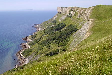
Click image to see photo description.
This energetic walk offers exceptional coastal views and starts from car park in the deserted village of Tyneham (Grid ref. SY882802). Tyneham was evacuated in 1943 prior to D-Day and the villagers were never allowed back. There is also a small museum.
From the car park walk south to Tyneham Farm and take the ascending track and path south to the top of Gad Cliff (grid ref. SY884796). You immediately have a wonderful coastal panorama along the Dorset Coast. Turn right onto the South West Coast Path with the sea to your left. The path descends slowly at first before dropping more steeply down to Warbarrow Bay.
Like all coastal walking the path follows a switchback and you soon start to climb again to the ancient hill fort of Flower?s Barrow (grid ref. SY864805). At this point we are going to turn right inland to Whiteway Hill but before doing so it's worth walking a short way west to enjoy the view along the coast towards Lulworth.
Take the signed path along the ridge eastwards to Whiteway Hill (grid ref. SY876809). Continue in the same direction towards the next summit along the ridge, Povington Hill, descending to reach a road (grid ref. SY881810). Follow the path to Povington Hill (grid ref. SY887811) which offers a wonderful panorama.
Having enjoyed the view, retrace your route along the ridge path bearing left downhill on a signed track at grid ref. SY881810 towards Tyneham village. The descent is gentle and you have a good view of the remains of the village below. Walk through the village to return to the car park.
Other walks nearby
| Walk 1331 | Kimmeridge & Tyneham | easy/mod | 6.8 miles |
| Walk 1534 | Swyre Head & Tyneham Cap from Kimmeridge | moderate | 11.8 miles |
| Walk 1995 | Houns-tout & Swyre Head from Kimmeridge | moderate | 8.7 miles |
| Walk 1004 | Durdle Door & Lulworth Cove | easy | 2.5 miles |
| Walk 1329 | Durdle Door & White Nothe from Lulworth Cove | moderate | 7.0 miles |
| Walk 3389 | Bindon Hill and the Fossil Forest from Lulworth | easy/mod | 4.0 miles |
| Walk 2145 | Houns-tout Cliff from Kingston | easy | 3.5 miles |
| Walk 2925 | St Aldhelm's Head near Worth Matravers | easy | 4.1 miles |
| Walk 3286 | Dancing Ledge & Durlston Head from Langton Matravers | easy/mod | 7.0 miles |
| Walk 2575 | Durdle Door & Lulworth Cove | moderate | 10.0 miles |
Recommended Books & eBooks
Walking the Jurassic Coast
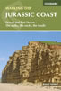 This guidebook includes 30 walks on the Jurassic Coast of Devon and Dorset. Covering the coast between Exmouth and Bournemouth, these delightful routes range from 3 to 16 miles (5 to 24km), exploring and explaining the spectacular geology of this World Heritage area with clear, easily understood descriptions, cross-sections and timelines.
More information
South West Coast Path Map Booklet - Minehead to St Ives
 Map of the northern section of the 630 mile (1014km) South West Coast Path National Trail. Covers the trail from Minehead to St Ives along the north Devon and Cornish coastline. This convenient and compact booklet of Ordnance Survey 1:25,000 maps shows the route, providing all of the mapping you need to walk the trail in either direction.
More information
Messaging & Social Media
Message Walking Britain and follow the latest news.

Mountain Weather
Stay safe on the mountains with detailed weather forecasts - for iOS devices or for Android devices.