Charlton, Singleton & Goodwood Circular
South Downs Walk
Nat Park - South Downs
County/Area - West Sussex
Author - Lou Johnson
Length - 6.5 miles / 10.6 km Ascent - 800 feet / 242 metres
Time - 4 hours 0 minutes Grade - easy/mod
Maps 

| Ordnance Survey Explorer OL8 | Sheet Map | 1:25k | BUY |
| Anquet OS Explorer OL8 | Digital Map | 1:25k | BUY |
Walk Route Description
Click image to see photo description.
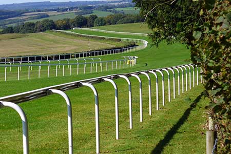
This walk in the South Downs National Park starts from the village of Charlton. The route includes Levin Down, the village of Singleton, views along the Lavant Valley, Goodwood Racecourse and views as far afield as Chichester Cathedral. The undulating walk follows waymarked bridleways, paths, and lanes. It is worth noting that you should avoid race days when completing this walk.
The walk starts in the village of Charlton where limited on-street parking is available near the Fox Goes Free pub (grid ref. SU889130). After parking and with the pub behind you turn left (west) along Charlton Road. Take the first road on the right (North Lane). Continue north amidst rolling downs along the tarmac lane. Pass Ware Barn on your right Pass a track, also on your right, and continue to the next junction (grid ref.SU890142) where you turn left onto a track through trees. Exiting the trees, your reach an open area with several fingerposts (grid ref. SU889145).
Turn left onto bridleway signed to Singleton to cross the western flank of Levin Down. The clear path heads south-west across the down before crossing a field to reach Charlton Road in Singleton (grid ref. SU879132). Bear right and follow Charlton Road through the village. Where the road forks, bear left and then take the second turn on the left (opposite the Partridge Inn) and continue to the Blessed Virgin Mary church (grid ref. SU878130). Bear left in front a wall and turn right by the fingerpost to locate the onward path (signed to The Trundle).
The onward path skirts Manor Farm on your right and climbs steadily to join a lane through a wooden gate. Bear right along the lane with a wide grass verge on the left. Continue climbing to road junction. Continue ahead past a car park (grid ref. SU879114) on your right (could be used as an alternative start). Just before the next junction bear right, cross the road, and climb the steps and a path to the summit of The Trundle (grid ref. SU877110).
From the summit turn east along the Monarch's Way and descend to a road opposite the entrance to Goodwood Racecourse. Turn right and continue to the next junction and turn left (signed to East Dean. Follow this road for about a kilometre to where the road swings right (grid ref. SU897114). Turn sharp left onto a track (with fingerpost) and follow the 'Chalk Road' back to Charlton.
Other walks nearby
| Walk 3548 | Stoughton, Kingley Vale & Bow Hill from Stoughton Down | easy/mod | 5.2 miles |
| Walk 1835 | Treyford & Didling from Hooksway | easy/mod | 6.0 miles |
| Walk 2232 | Midhurst and Woolbeding | easy/mod | 6.0 miles |
| Walk 2044 | Six Harbour Villages, Chichester | moderate | 10.0 miles |
| Walk 1425 | Midhurst Way - Petworth to Midhurst | easy/mod | 5.5 miles |
| Walk 2368 | Bosham & Fishbourne | easy | 5.2 miles |
| Walk 2828 | Dell Quay from Chichester Marina | easy | 3.8 miles |
| Walk 1917 | Rackham Hill from Amberley | easy/mod | 6.5 miles |
| Walk 1615 | Amberley & East Dean Circular | mod/hard | 21.0 miles |
| Walk 1466 | Amberley and Arundel Circular | moderate | 13.0 miles |
Recommended Books & eBooks
Walks in the South Downs National Park
 Guidebook with 40 circular walks throughout the South Downs National Park, exploring the beautiful chalk hills between Eastbourne and Winchester. The walks range from under 5 miles to 11 miles, including Beachy Head and the Seven Sisters, Ditchling Beacon and hundreds of prehistoric sites. Accessible all year, but wild flowers best in spring.
More information
Messaging & Social Media
Message Walking Britain and follow the latest news.

Mountain Weather
Stay safe on the mountains with detailed weather forecasts - for iOS devices or for Android devices.