Walk 2139 - printer friendly version
Clumber Park and Lake Walk
Author - Lou Johnson
Length - 4.0 miles / 6.5 km
Ascent - 200 feet / 61 metres
Grade - easy
Start - OS grid reference SK626747
Lat 53.2656110 + Long -1.0629136
Postcode S80 3BG (approx. location only)
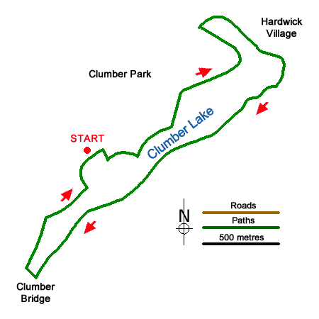
This relaxing Nottinghamshire walk explores Clumber Park and Lake. The grounds were landscaped in the eighteenth century and today are managed by the National Trust. The route offers excellent views across the lake and if time permits you can explore the many facilities on offer. A longer walk in Clumber Park can be found at Walk 2139.
The start is the National Trust car park at Clumber Park (grid ref. SK626747). After parking follow the signs to the "Chapel". Just before the chapel, turn left and continue to the next junction. Turn right to the lakeshore and turn left with the lake on your right. After 350 metres the path bears left away from the lake. At the first junction bear right and follow the path ahead into Ash Tree Hill Wood. Keep ahead at two junctions and continue to reach a wider track. Turn right and follow the track to a lane (grid ref. SK634756).
Turn right along the lane across a causeway. Take the first path on the right which follows the lake shore. Continue along the shoreline path past a café. The path soon crosses a footbridge across weir on your left. Continue following the path alongside the lake for two kilometres to reach the attractive Clumber Bridge. Cross the bridge and take the first path on the right. This leads through trees to a road (grid ref. SK622742). Turn right along the road and continue back to the car park.
Messaging & Social Media
Message Walking Britain and follow the latest news.

Mountain Weather
Stay safe on the mountains with detailed weather forecasts - for iOS devices or for Android devices.