Romaldkirk & Cotherstone
Durham Walk
County/Area - Durham
Author - Lou Johnson
Length - 5.0 miles / 8.1 km Ascent - 350 feet / 106 metres
Time - 2 hours 50 minutes Grade - easy
Maps 

| Ordnance Survey Explorer OL31 | Sheet Map | 1:25k | BUY |
| Anquet OS Explorer OL31 | Digital Map | 1:25k | BUY |
Walk Route Description
Click image to see photo description.
A relaxing walk from Romaldkirk in County Durham that includes a section alongside the River Tees, the village of Cotherstone and a section along a disused railway line (Teesdale Railway Walk). Both Romaldkirk and Cotherstone are attractive villages. Both villages have pubs. A section of the route follows the Teesdale Way.
The start of the walk is the village green on the east side of the B6277 in Romaldkirk (grid ref. NY994220). On street parking is available nearby. After parking walk east towards the Rose & Crown to the left of an area of grass. Bear right to follow the lane passing in front of the village hall (Sennings Lane). After 150 metres turn right at a fingerpost to join the Teesdale Way towards Cotherstone. Continue ahead for 400 metres ignoring a path on the right. Nearing the end of a stand of trees on the left, leave the walled track and head half right across two fields to join a grassy track which continues to Low Garth (grid ref. NZ003216).
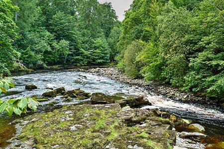
After Low Garth turn left over a stile to continue along the Teesdale Way. The path heads half right across a field to enter woodland to join a path with the River Tees on your left. After a short section beside the river the path veers right and continues to a gate at the end of a barn. Pass in front of Wodencroft (grid ref. NZ008208) and bear left through gate to continue along the Teesdale Way. The path follows a wall on your left and then maintain direction down to the River Tees. Continue beside the river to pass a footbridge over the Tees. Continue ahead soon crossing the River Balder (grid ref. NZ013201).
Once across this bridge bear right and follow a tarmac path towards Cotherstone. The path soon widens , passes a football pitch on the left, and leads uphill to a road junction. Bear right and continue uphill to reach the B6277 (grid ref. NZ011198).Turn left and almost immediately right down a narrow lane at the left-hand end of a row of terraced houses. After 60 metres turn right down a narrow road and continue to where the lane bends right by a wooden seat. Turn left and continue ahead for 350 metres to reach the disused railway.
Turn right and follow the Tees Railway Walk for 3.5 kilometres. After crossing the first lane, the walk takes you across Balderstone Viaduct over the River Balder, which was crossed on the approach to Cotherstone. After the viaduct the path crosses another minor lane before reaching a road after passing through a metal gate. Turn right and continue to the B5277 where you bear left back to the start.
Other walks nearby
| Walk 2228 | Romaldkirk Moor | easy/mod | 7.6 miles |
| Walk 1005 | Harter Fell & Grassholme | moderate | 8.0 miles |
| Walk 1482 | Crossthwaite Common from Middleton-in-Teesdale | moderate | 9.8 miles |
| Walk 1483 | Eggleston & Romaldkirk from Middleton-in-Teesdale | easy/mod | 9.8 miles |
| Walk 1484 | Kirkcarrion from Middleton-in-Teesdale | easy | 3.5 miles |
| Walk 1485 | Hamsterley & Middleton-in-Teesdale | mod/hard | 16.5 miles |
| Walk 1488 | Middleton-in-Teesdale Railway Walk | easy | 2.5 miles |
| Walk 2258 | Grassholme Reservoir from Middleton-in-Teesdale | moderate | 8.2 miles |
| Walk 1553 | Hannah's Meadow, Baldersdale & Brown Rigg Moss | easy/mod | 8.0 miles |
| Walk 2469 | Great Allotment & God's Bridge | moderate | 10.2 miles |
Recommended Books & eBooks
Walking in County Durham
 Guidebook offering detailed descriptions of 40 day walks, plus 10 traffic-free cycle routes along old railway trackbeds. Together they cover 450 miles and spread all over County Durham to show the region's history and natural wonders. The terrain covered ranges from field paths to open moorlands, from the North Sea to the high Pennines.
More information
Messaging & Social Media
Message Walking Britain and follow the latest news.

Mountain Weather
Stay safe on the mountains with detailed weather forecasts - for iOS devices or for Android devices.