Walk 2162 - printer friendly version
Clumber Park & Freeboard Lane Walk
Author - Lou Johnson
Length - 5.5 miles / 8.9 km
Ascent - 400 feet / 121 metres
Grade - easy
Start - OS grid reference SK626747
Lat 53.2656110 + Long -1.0629136
Postcode S80 3BG (approx. location only)
This circular walk explores Clumber Park, the lake and woodland by Freeboard Lane. The route follows good paths and bridleways that in general are well waymarked. The park was landscaped in the eighteenth century and today is managed by the National Trust. During your visit allow time to explore other points of interest in and around the park. A shorter walk in Clumber Park can be found at Walk 2139.
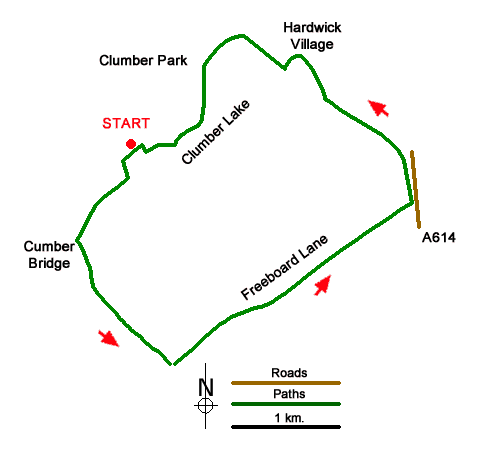
The start is the National Trust car park at Clumber Park (grid ref. SK626747). After parking walk to car park entrance and bear right along the tarmac footpath cum cycleway running beside the road. Where the road forks, bear left along a tarmac path and continue through trees to reach Clumber Bridge (grid ref. SK621738). Cross the bridge and bear right along a tarmac drive signed to South Lodge. Continue on a track through woodland to reach South :Lodge and gates. Reaching a path junction before the gates, turn left and then bear right through a gap to a track with fingerpost (grid ref. SK629728).
Turn left (signed to Ollerton) and follow the track through woodland for just over two kilometres to reach a fingerpost indicating the route for a permissive bridleway to Clumber. Turn left along the permissive route and keep ahead at the first two junctions. Shortly after the second junction bear half-left across grass initially beside Cabin Hill Covet on your left. Reaching a lane (grid ref. SK642751), bear right and cross the River Poulter. Follow the lane past Hardwick Grange on your left to where the lane bends right. At this point bear left down to the lake. Turn right along the lake soon passing a café and continue ahead to a tarmac lane. Bear left across the lake and where the lave forks (grid ref. SK634756) , go half-left.
Keep ahead for 350 metres and turn left (grid ref. SK631753). Follow the path to reach the lake. Bear right alongside the lake and continue for 300 metres to a path junction (grid ref. SK629746). Turn right away from the lake. At the next junction turn left and continue beside the church. At the end of the chapel turn right and return to car park used at the start of the walk.
Messaging & Social Media
Message Walking Britain and follow the latest news.

Mountain Weather
Stay safe on the mountains with detailed weather forecasts - for iOS devices or for Android devices.