Bridlington & Flamborough Head
East Yorkshire Walk
County/Area - East Yorkshire
Author - Lou Johnson
Length - 6.8 miles / 11.1 km Ascent - 700 feet / 212 metres
Time - 4 hours 10 minutes Grade - easy/mod
Maps 

| Ordnance Survey Explorer 301 | Sheet Map | 1:25k | BUY |
| Anquet OS Explorer 301 | Digital Map | 1:25k | BUY |
Walk Route Description
Click image to see photo description.
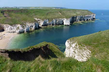
Starting from Bridlington this linear walk follows the Headland Way along the coast to Flamborough Head and North Landing. From North Landing there is bus service 14 back to Bridlington. The route offers excellent views along the coast, explore the sheer chalk cliffs of the headland, see two former lighthouse towers and up to 20,000 nesting sea birds in season. The undulating path is typica of coastal walks with many descents and ascents.
The walk starts from Lime Kiln Lane car park (grid ref. TA193681) at the northern end of Bridlington. After parking walk through the car park to North Beach. Turn left and follow the clear path (Headland Way) with the sea on your right. After nearly three kilometres of easy walking, you reach Danes Dyke, where the path briefly turns inland before returning to the cliff tops. The next landmark is South Landing where a lifeboat station can be found. Cross the car park and climb the steps opposite. At the top a short detour to visit the art installation before returning to the cliff top path.
Continue along South Cliff to reach the cliffs of Flamborough Head. The cliffs are home to thousands of nesting birds, and it is worth lingering to fully appreciate the remarkable scene. Pass to the left of the Fog Signal Station and continue to the New Flamborough Head Lighthouse. A few metres past the lighthouse, turn right and continue along to a viewing platform above the beach. Climb the steps away from the platform and at the next junction bear right to continue along the Headland Way. After a relatively quiet section you reach the hustle and bustle of North Landing, with its shops, cafes, and small beach. Continue along the road to the bus shelter on the left for the bus back to Bridlington where the bus passes close to the car park used at the start of the walk.
Other walks nearby
| Walk 1620 | Flamborough Head | easy/mod | 9.7 miles |
| Walk 2921 | Bempton Cliffs | easy/mod | 6.7 miles |
| Walk 3428 | Boynton from Rudston Circular | easy | 6.5 miles |
| Walk 1433 | Martin & Metheringham circular | easy | 6.3 miles |
| Walk 1630 | Filey, Camp Dale & Hunmanby | moderate | 10.5 miles |
| Walk 3247 | Stockingdale and Muston from Hunmanby | easy/mod | 7.8 miles |
| Walk 2482 | Fordon and Dales Circular | easy/mod | 5.2 miles |
| Walk 1575 | Tophill Reservoir | easy | 3.0 miles |
| Walk 3740 | Cowlam & Cottam Circular | easy/mod | 8.0 miles |
| Walk 1631 | Scarborough to Filey | moderate | 10.2 miles |
Recommended Books & eBooks
No suggestions for this area.Messaging & Social Media
Message Walking Britain and follow the latest news.

Mountain Weather
Stay safe on the mountains with detailed weather forecasts - for iOS devices or for Android devices.