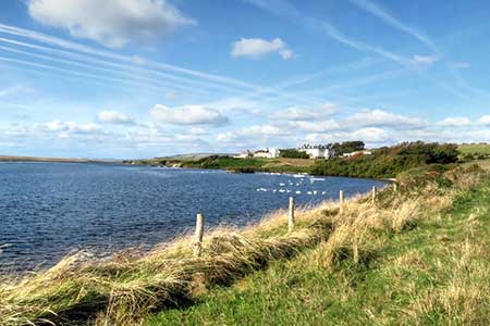
The Fleet from Langton Herring
Jurassic Coast Walk
Region - Jurassic Coast
County/Area - Dorset
Author - Lou Johnson
Length - 7.0 miles / 11.4 km Ascent - 530 feet / 161 metres
Time - 4 hours 0 minutes Grade - easy/mod
Maps 

| Ordnance Survey Explorer OL15 | Sheet Map | 1:25k | BUY |
| Anquet OS Explorer OL15 | Digital Map | 1:25k | BUY |
Walk Route Description
Click image to see photo description.
A leisurely walk from Langton Herring exploring the shores of the Fleet and the rolling landscape inland. The Fleet is a shallow tidal lagoon behind Chesil Beach (or Chesil Bank) which stretches 29 kilometres from near Abbotsbury to the Isle of Portland. The route follows the shore of the lagoon using the South West Coast Path National Trail. Later in the walk a short section of the Hardy Way is used to return to Langton Herring.
The start is a layby at the western end of Langton Herring (grid ref. SY610828) which is on the road to Rodden and lies just past the village sewage works. After parking walk back towards the village and turn right at the first track. Follow the waymarked path which runs along the left-hand edge of a field. Turn left over the first stile ad walk uphill to a cross path. Turn right downhill with a hedge on your right to pass through a gate at the bottom. Joining the South West Coast Path, which comes in from the right. Continue past an information board at Rodden Hive and, soon after, continue along the path with The Fleet and Chesil Beach on your right.
The path soon turns east to reach a path junction (grid ref. SY616814) with the Hardy Way. The route returns to this point towards the end of the walk. Turn right and continue along the South West Coast Path, passing Herbury headland. The next landmark is Moonfleet Manor Hotel on your left. Continue for a further two kilometres to Butterstreet Cove. Turn left off the coast path following the Hardy Way and continue past the remains of tiny East Fleet Church to join Fleet Road (grid ref. SY636801). Turn left soon passing Holy Trinity Church on the right which was built after East Fleet church was destroyed. 800 metres beyond the church you reach a road junction (grid ref. SY628809).
Fork right, signed to West Fleet Holiday Farm. The drive bends right and continues as a concrete track. Keep ahead at all junctions and continue to pass Bagwell Farm on your left. Turn left through a gap just to the left of a gate with yellow-arrow waymark. Pass to the right of a brick barn and walk diagonally over grass to join a track which is followed down the campsite to join a path (signed to coast path) with a hedge on your right. Reaching a track at the path junction mentioned in three, turn right and continue uphill along the Hardy Way back to Langton Herring. At the edge of the village, turn right along Shop Lane and continue past the pub to the 'main road'. Turn left back to the start.
Other walks nearby
| Walk 3523 | Abbotsbury & Portesham Circular | easy | 5.2 miles |
| Walk 2289 | Abbotsbury Castle and Chesil Beach | easy/mod | 6.0 miles |
| Walk 2565 | Littlebredy from Abbotsbury | moderate | 8.5 miles |
| Walk 2827 | Rodden & Langton Herring from Abbotsbury | easy/mod | 9.2 miles |
| Walk 2494 | West Bexington & Abbotsbury Circular | moderate | 7.7 miles |
| Walk 1597 | The White Horse & Sutton Poyntz from Osmington | easy/mod | 4.0 miles |
| Walk 2440 | White Nothe & Moigns Down from Osmington | moderate | 10.5 miles |
| Walk 1889 | White Nothe from Ringstead Bay | easy/mod | 5.8 miles |
| Walk 2575 | Durdle Door & Lulworth Cove | moderate | 10.0 miles |
| Walk 3629 | Eggardon Hill from Loders | moderate | 8.4 miles |
Recommended Books & eBooks
The South West Coast Path
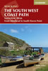 Guidebook to walking the entire South West Coast Path National Trail. The route runs for 630 miles from Minehead to Poole along the north Devon, Cornish, south Devon and Dorset coastline. Divided into 45 stages, this long-distance coastal trek could be completed within 4 weeks, or walked in sections. Guide includes maps and essential information.
More information
South West Coast Path Map Booklet - Minehead to St Ives
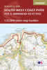 Map of the northern section of the 630 mile (1014km) South West Coast Path National Trail. Covers the trail from Minehead to St Ives along the north Devon and Cornish coastline. This convenient and compact booklet of Ordnance Survey 1:25,000 maps shows the route, providing all of the mapping you need to walk the trail in either direction.
More information
Messaging & Social Media
Message Walking Britain and follow the latest news.

Mountain Weather
Stay safe on the mountains with detailed weather forecasts - for iOS devices or for Android devices.