Walk 2387 - printer friendly version
Pinkery Pond Circular Walk
Author - Lou Johnson
Length - 5.8 miles / 9.4 km
Ascent - 650 feet / 197 metres
Grade - easy/mod
Start - OS grid reference SS729401
Lat 51.1460100 + Long -3.8184255
Postcode TA24 7LQ (approx. location only)
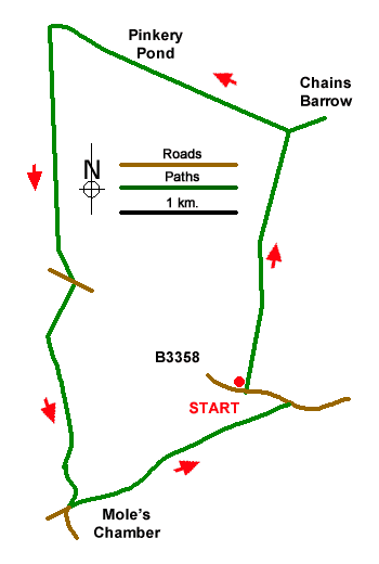
This circular walk explores an area lying a few miles west of Simonsbath. The first part of the route includes the Bronze Age burial mound of Chains Barrow, and Pinkeys Pond a remote reservoir on land where substantial rainfall in August 1952 resulted in the loss of like and damage to property in Lynmouth. The final part of the walk passes Mole's Chamber the site of an inn that had a doubtful reputation. The Acland Arms closed in the 1880's a is now a remote pile of rubble.
The start is a layby (grid ref. SS729401) on the north side of the B3358 just over four kilometres west of Simonsbath. After parking take the signed bridleway on the north side of the road signed to the Chains. The path crosses two fields keeping to the right-hand Maintain direction across an area of rougher pasture following the blue waymarks to reach a gate at a path junction (grid ref. SS732418). Head through the gate and take the grassy path heading half-right to gain the summit of the Chains with its OS trig column. In fine weather the view is extensive and includes South Wales and Bideford Bay.
Retrace your steps back to the path junction and turn right (signed Pinkery Pond). Follow the path beside a fence to reach the reservoir. Cross the dam wall and continue through a gate to enter a field. Head for the right-hand corner at Woodbarrow Gate with Wood Barrow adjacent. Turn left and follow the path, part of the Tarka Trail, to the B3358. Cross the road with care to the gate opposite and join the bridleway signed to Mole's Chamber. The grassy track is waymarked and leads to a lane with a nearby memorial stone (grid ref. SS718394).
Just before the lane, turn sharp left and continue to Moles's Chamber. The bridleway soon crosses a stream and continues with the stream on your left. Continue along the clear path to the B3358. Turn left and using the grass verge where possible return to the parking area 300 metres ahead on the right-=hand side of the road.
Messaging & Social Media
Message Walking Britain and follow the latest news.

Mountain Weather
Stay safe on the mountains with detailed weather forecasts - for iOS devices or for Android devices.