Edwinstowe, Sherwood Forest & Major Oak circular
Nottinghamshire Walk
County/Area - Nottinghamshire
Author - Lou Johnson
Length - 5.9 miles / 9.6 km Ascent - 250 feet / 76 metres
Time - 3 hours 10 minutes Grade - easy
Maps 

| Ordnance Survey Explorer 270 | Sheet Map | 1:25k | BUY |
| Anquet OS Explorer 270 | Digital Map | 1:25k | BUY |
Walk Route Description
Click image to see photo description.
Sherwood Forest in the heart of Nottinghamshire is famous for its connection with the legends of Robin Hood. This walk explores some of the woodland including the ancient the Major Oak using a number of easy to follow tracks and paths. The start is the large pay and display car park (grid ref. SK626676) close to the visitor centre just off the B6034 on the north side of Edwinstowe, which lies on the A6075 between Ollerton and Mansfield.
After parking follow the Greenwood Walk and then Clipstone Walk west for just over a mile to reach a broad open "avenue" running north to south (grid ref. SK606670). Turn left here and continue walking until you reach the A6075 (grid ref. SK606663). Turn right along the A6075 for about 250 metres and then right onto the Robin Hood's Way (grid ref. SK604662) following the green arrows, passing a memorial to reach a T-junction (grid ref. SK590666). Turn right staying on the Robin Hood's Way for a mile to reach a T-junction (grid ref. SK598661).
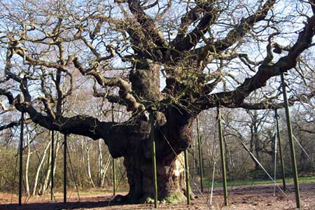
Leave the Robin Hood's Way, first going left and then right. After 250 metres you reach a fork. Continue straight ahead here ignoring the right-hand path (grid ref. SK600683). After 600 metres you cross the Robin Hood's Way (grid ref. SK606685). After 200 metres take the right fork following a bridleway. After just over a kilometre you reach a junction (grid ref. SK616678). Go left here (do not fork right uphill) and keep straight ahead to the Major Oak (grid ref. SK620679) and continue back to the visitor centre and the car park.
Other walks nearby
| Walk 2540 | The Robin Hood Way Long Distance Circular | mod/hard | 27.0 miles |
| Walk 2139 | Clumber Park and Lake | easy | 4.0 miles |
| Walk 2162 | Clumber Park & Freeboard Lane | easy | 5.5 miles |
| Walk 1460 | Hardwick Hall park | easy | 2.5 miles |
| Walk 2134 | Linby and Newstead Abbey circular | easy | 5.9 miles |
| Walk 1513 | Newstead Abbey from Linby | easy | 5.8 miles |
| Walk 3586 | Rolleston & Morton from Fiskerton | easy | 6.3 miles |
| Walk 2725 | Chesterfield Canal and Anston Brook from Kiveton | moderate | 10.2 miles |
| Walk 1133 | Gunthorpe & Caythorpe from Hoveringham | easy/mod | 7.0 miles |
| Walk 2823 | Greasley & Moorgreen Reservoir | easy | 5.9 miles |
Recommended Books & eBooks
No suggestions for this area.Messaging & Social Media
Message Walking Britain and follow the latest news.

Mountain Weather
Stay safe on the mountains with detailed weather forecasts - for iOS devices or for Android devices.