Withypool & Barle Valley Walk
Walk 2451 - Route Maps
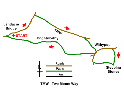
Route Map
Digital Maps - Copyright © 2011-2024. All rights reserved.
Sketch Map
Suggested Maps 

It is recommended you take a map. The preferred scale is 1:25k.
Start Point Details
Ordnance Survey Grid Ref SS815361
Latitude 51.111905 Longitude -3.694222
Postcode TA24 7SD
what3words start clay.date.motored
Walk description may contain detailed information on the start point for this walk.
Further Information
Exmoor
Walking in the Exmoor National Park, which lies in West Somerset and North Devon, includes a dramatic section of coast. Wild moorland dominates the high ground with Dunkery Beacon the highest point within the National Park. Wooded valleys or combes cut deep into this upland and provide another typical feature of the landscape. The coast includes some of the highest cliffs in the UK with easy access provided by the South West Coast National Trail. Exmoor Walking Guide
Somerset
Somerset is a rural county in south-west England. The high land of the Blackdown Hills, Mendip Hills, Quantock Hills and Exmoor National Park, contrast with the wide expanses of flat wetland including the Somerset Levels. Adding interest to the landscape are the extensive network of caves and the Cheddar Gorge. Exmoor National Park crosses the border into neighbouring Devon and provides excellent walking. The highest point in Somerset is Dunkery Beacon on Exmoor, with an altitude of 519 metres (1,703 feet). The coast also offers great walking especially the section of South West Coast Path west of Minehead.
Walk grading - Learn how each walk is assessed and select a walk to suit your ability and experience by going to Walk Grading Details.
Messaging & Social Media
Message Walking Britain and follow the latest news.

Mountain Weather
Stay safe on the mountains with detailed weather forecasts - for iOS devices or for Android devices.