Walk 2465 - printer friendly version
Steeple Langford Circular Walk
Author - Lou Johnson
Length - 9.8 miles / 15.9 km
Ascent - 800 feet / 242 metres
Grade - moderate
Start - OS grid reference SU036375
Lat 51.1367610 + Long -1.9499248
Postcode SP3 4NG (approx. location only)
Circular walk from Steeple Langford (Wiltshire) exploring the surrounding downs and the Wylye Valley. The route includes open countryside, downs, woodland, a section beside the River Wylye, a former Roman road and part of the Monarch's Way.
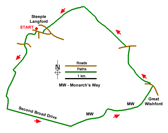
The walk starts from All Saints Church, Salisbury Road in Steeple Langford (grid ref. SU036375). On street parking is available nearby. After parking and with your back to the church, turn left and take the first track on the left with adjacent fingerpost. The track crosses two bridges before bearing right to briefly follow the river. After 200 metres the track bears left and passes through trees to exit onto Wylye Road (grid ref. Su032371).
Cross the road to the track opposite (the Hollow), cross the railway and follow the rising track onto the downs. Pass Holloway Barn on your left and continue ahead for 500 metres where the main track turns sharp left. Follow the track left and at the end of the field, turn right and follow the path along the left-hand field boundary. After 500 metres of gentle ascent, you reach woodland. Bear left on a path through trees. After 70 metres turn right onto a feint path (waymark on tree) and continue to Second Broad Drive after 300 metres (grid ref. SU026348).
Turn left along the route of a Roman Road and continue ahead for 2.5 kilometres to a barrier. Continue ahead for another 150 metres to the next junction and bear left along a woodland road (grid ref. SU049341). You are now following a section of the Monarch's Way. After 1500 metres you exit the trees by a parking area. Continue ahead descending into the valley. Continue under the railway, pass the Royal Oak in Great Wishford), and turn left. After 200 metres the road bends left. Leave the road here to join a path that soon reaches a bridge over the River Wylye (grid ref. SU077357).
Cross the bridge and turn left and follow the riverside path upstream to reach Kingsmead Bridge. Do not cross the bridge but maintain direction across a field to a stile where the river completes a loop. Entering the next field, bear left to continue beside the river. After reaching a wooden footbridge After this bridge veer right away from the river, cross two footbridges near a stile. The path continues along the left-hand edge of a field, crosses a stile, and leads to the A36 in Serrington (grid ref. SU069370).
Turn left, pass The Pelican (on your left), and after 150 metres turn right onto a signed byway (Stapleford Road). The clear track climbs gently for two kilometres to reach a hilltop crossroads (grid ref. SU053284). Turn left, pass a pit on your right a woodyard on your right to reach a T-junction. Continue ahead onto a grassy track. This track leads down to the A36. Cross the main road with care to the footpath opposite. This leads into a cul-de-sac. Walk ahead to Salisbury Road and turn right back to the start near Steeple Langford church.
Messaging & Social Media
Message Walking Britain and follow the latest news.

Mountain Weather
Stay safe on the mountains with detailed weather forecasts - for iOS devices or for Android devices.