Binnein Mor from Kinlochleven
Highland Walk
County/Area - Highland - Fort William Lochaber
Author - Peter Smyly
Length - 10.2 miles / 16.6 km Ascent - 4170 feet / 1264 metres
Time - 9 hours 20 minutes Grade - hard
Maps 

| Ordnance Survey Explorer 384 | Sheet Map | 1:25k | BUY |
| Anquet OS Explorer 384 | Digital Map | 1:25k | BUY |
| Ordnance Survey Landranger 41 | Sheet Map | 1:50k | BUY |
| Anquet OS Landranger 41 | Digital Map | 1:50k | BUY |
Walk Route Description
Click image to visit gallery of 6 images.
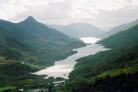
At 3,707 feet, Binnein Mor, the highest peak in the Mamores range in Scotland, is one of 56 mountains in Scotland that are higher than Snowdon, the highest mountain in Wales. Start at Kinlochleven, a village at the eastern end of the sea loch of Loch Leven in the Lochaber area of Scotland. From nearby Kinlochmore, follow one of the paths that lead north-east up through woodland and out on to open fell to the east of the Mamore Lodge Hotel. There is a fine retrospective view of Loch Leven overlooked to the left as you look by the pyramid-like shape of the Pap of Glencoe with the houses of Kinlochleven in the valley below among the trees in the foreground. The path heads roughly north-east to skirt the lower slopes of Sgor Eilde Beag. Before that, there is at least one burn (stream) to cross. The map shows the name of the burn as being the Allt Coire nan Laogh.
The footpath leads up to the north-east towards the lochan, Coire an Lochain, beyond which, and overlooking it, is the dome-shaped mountain, Sgurr Eilde Mor. Before you get to the lochan, this route follows a path that zig zags steeply up Sgor Eilde Beag to the left. The view from this minor summit and its ridge towards Binnein Mor, looking down on Coire an Lochain, is particularly dramatic. The route leads north-west along a ridge that dips first before rising to reach an unnamed top more or less half way between Na Gruagaichean and Binnein Mor before following the crest of the ridge to Binnein Mor.
The rocky summit of Binnein Mor is small with a sizeable cairn and is the highest point of the tent-like ridge. On the occasion of my visit in May 2006, a hail storm descended on arrival at the summit but within a matter of minutes after going back down the ridge, it had cleared and the sun had come out. Even in May, there may be patches of snow on the summit ridge. The view to the west reveals the eastern section of the Ring of Steall horseshoe, one of the classic walks of the Scottish Highlands. The difficulty with trying to include Sgurr Eilde Mor and Binnein Beag to the north east from Binnein Mor in a circular route is that it would involve significant height losses which would later need to be regained. The dome shape of Sgurr Eilde Mor dominates the view to the south-east with Coire an Lochain below it, a large and picturesque lochan with an irregular outline in an area of high mountains where lochans are few.
Reverse the outgoing route to return to the start point of the walk. Alternatively, if time, the weather and energy levels are all favourable, the route can be varied by including one or more additional Munros, such as Na Gruagaichean to the south-west or Binnein Beag to the north east, bearing in mind the extra height loss which needs to be regained.
Other walks nearby
| Walk 1496 | WHW - Day 6 - Kinlocheven to Fort William | moderate | 15.0 miles |
| Walk 2554 | The Lost Valley, Glen Coe | easy/mod | 4.2 miles |
| Walk 3251 | Bidean nam Bian via Stob Coire nan Lochan, Glencoe | hard | 5.0 miles |
| Walk 2808 | Buachaille Etive Beag, Glen Coe | hard | 9.0 miles |
| Walk 2955 | Ridges & peaks of Bidean Nam Bian | very hard | 10.5 miles |
| Walk 2819 | Stob na Broige, Buchaille Etive Mor, Glen Coe | mod/hard | 6.1 miles |
| Walk 3010 | Stob Dearg (Buachaille Etive Mor) from Altnafeadh | mod/hard | 4.0 miles |
| Walk 3269 | The Munros of Buachaille Etive Mor | mod/hard | 8.2 miles |
| Walk 3303 | Mamores Ridge - Stob Ban, Am Bodach and Sgurr an Iubhair | hard | 9.0 miles |
| Walk 3095 | Stob Ban (Mamores) | mod/hard | 6.0 miles |
Recommended Books & eBooks
Walking the Munros Vol 2 - Northern Highlands and the Cairngorms
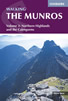 Guidebook to walking the northern Munros, covering the northern Highlands, the Cairngorms and the Isle of Skye. 70 routes are described, including those up Ben Macdui, Braeriach and Cairn Gorm. Routes range from 7 to 46km, requiring a fair level of fitness. The second of two guidebooks to walking Scotland's Munros: peaks higher than 3000ft.
More information
Walking in Torridon
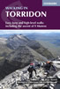 This guidebook contains 52 day walks in Torridon, a remote and much-loved area of the Scottish Highlands. Based around Shieldaig and Slioch, the routes are split into 3 sections: easy walks, long and high level walks and mountain ascents over 2000ft including 9 Munros, and 5 outline suggestions for major ridge walks.
More information
Messaging & Social Media
Message Walking Britain and follow the latest news.

Mountain Weather
Stay safe on the mountains with detailed weather forecasts - for iOS devices or for Android devices.