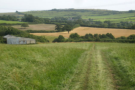
Eggardon Hill from Powerstock
Dorset Walk
County/Area - Dorset
Author - Lou Johnson
Length - 6.3 miles / 10.2 km Ascent - 900 feet / 273 metres
Time - 4 hours 0 minutes Grade - easy/mod
Maps 

| Ordnance Survey Explorer 117 | Sheet Map | 1:25k | BUY |
| Anquet OS Explorer 117 | Digital Map | 1:25k | BUY |
Walk Route Description
Click image to see photo description.
This walk from Powerstock explores the beautiful Dorset countryside south of the village. The highlight of the walk are the views from Eggardon Hill, a former Iron Age fort. The route follows paths and tracks with a few sections along quiet country lanes. Refreshments are available in Powerstock and two other places along the route.
On street parking is available in Powerstock near St. Mary the Virgin Parish Church (grid ref. SY517962). After parking walk up the lane with the church on your immediate left. Continue past The Three Horseshoes Inn and turn right down the first footpath on your right signed to Nettlecombe. The path descends into the valley, crosses a stream, and then heads up a field to reach a road (grid ref. SY517956). Turn left past the Marquis of Lorne Inn along a narrow lane into Nettlecombe. At the first junction bear right (just after no.3) and continue up the lane to reach metal barriers on the left. Follow this path half right across a playing field and a second field to another lane (grid ref. SY520953).
Cross the lane to a stile opposite. Continue straight across the field to trees on the opposite side. Descend through the trees down to an old railway track. Continue ahead on a clear track (do not follow the old railway). Follow this track for two kilometres across Knowle Hill, past Lodersland Farm and out to the road at Spyway (grid ref. SY528933). Turn left past the Spyway Inn which is on your right. Take the next signed bridleway on the left just past the Inn. Follow the clear tarmac drive towards South Eggardon House. Just before the House, turn right onto a bridleway. At the first fence turn right and the soon after left to follow the field boundary. This bridleway descends diagonally across a slope to a road (grid ref. SY545939).
Turn left along the road and after 300 metres turn left (grid ref. SY546942). Follow this path to reach the ramparts of an Iron Age Fort on Eggardon Hill. A circuit of the ramparts is an option although most walkers head straight across the site enjoying the side ranging views. About 500 metres beyond the point where you entered the site at the northern end of the ramparts, follow a grassy track down to a gate and King's Lane (grid ref. SY540950).
Bear left along King's Lane and continue to where the lane bends right (grid ref. SY536952). Fork left onto a green lane and continue for 800 metres to where the track bends left (grid ref. SY528956). At this point continue ahead onto a footpath with a yellow waymark. The path descends following the hedge on your right to reach the old railway. Cross the railway and head down the field to far left-hand corner and a track (grid ref. SY521957). Bear right along the track and continue to a fingerpost just past a cottage on your right. Follow the path down an overgrown green lane and continue across a stream and up to a road (grid ref. SY519960). Turn left and return to the start of the walk in Powerstock.
Other walks nearby
| Walk 3629 | Eggardon Hill from Loders | moderate | 8.4 miles |
| Walk 2391 | West Bay & Burton Cliff | easy | 4.5 miles |
| Walk 2494 | West Bexington & Abbotsbury Circular | moderate | 7.7 miles |
| Walk 1549 | Golden Cap from Seatown | easy/mod | 4.0 miles |
| Walk 2565 | Littlebredy from Abbotsbury | moderate | 8.5 miles |
| Walk 2827 | Rodden & Langton Herring from Abbotsbury | easy/mod | 9.2 miles |
| Walk 2289 | Abbotsbury Castle and Chesil Beach | easy/mod | 6.0 miles |
| Walk 2580 | Golden Cap & Charmouth | easy/mod | 5.0 miles |
| Walk 3523 | Abbotsbury & Portesham Circular | easy | 5.2 miles |
| Walk 1328 | Minterne Magna & the Cerne Giant | easy/mod | 6.8 miles |
Recommended Books & eBooks
Walking the Jurassic Coast
 This guidebook includes 30 walks on the Jurassic Coast of Devon and Dorset. Covering the coast between Exmouth and Bournemouth, these delightful routes range from 3 to 16 miles (5 to 24km), exploring and explaining the spectacular geology of this World Heritage area with clear, easily understood descriptions, cross-sections and timelines.
More information
Messaging & Social Media
Message Walking Britain and follow the latest news.

Mountain Weather
Stay safe on the mountains with detailed weather forecasts - for iOS devices or for Android devices.