Walk 3283 - printer friendly version
Great Cockup and Meal Fell from Longlands Walk
Author - Lou Johnson
Length - 6.0 miles / 9.8 km
Ascent - 1600 feet / 485 metres
Grade - moderate
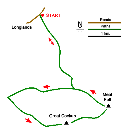
Start - OS grid reference NY266358
Lat 54.7118330 + Long -3.1408000
Postcode CA7 1HN (approx. location only)
This walk visits the summits of Great Cockup and Meal Fell in the northern fells of the Lake District. The route follows paths for most the way but there are sections where paths are indistinct. This area is generally quiet, and you are likely to see few walkers. In mist careful navigation is essential as the landscape can be confusing in poor visibility.
There is limited parking either side of the bridge over Longlands Beck (NY266358). After parking go through the gate on the north side of Longlands Beck and immediately bear right to ford a beck. Leave the track by bearing right along a grassy path. The path continues up the valley with a wall on your immediate right. Continue for a kilometre to reach sheep pens on your left (grid ref. NY271351). Continue along the grassy path to cross the River Ellen (grid ref. NY274342).
One across the river turn right along a grassy path which is initially hard to locate. However, the path soon becomes more distinct and soon crosses Dale Gill (grid ref. NY264342). About 700 metres beyond Dale Gill turn left and pick up a feint grassy path heading south-east onto the ridge terminating in Little Cockup (grid ref. NY262336). The path continues east to the summit of Great Cockup. Enjoy the view and also look east to Meal Fell so you can assess the lie of the land.
From the summit of Great Cockup head north-east on a grassy path. The path soon veers right (east) and descends towards Trusmadoor Pass. If you lose the path, choose the best route down to the southern end of the pass. From the pass there is a grassy path across the south flank of Meal Fell. Take this path and gain a little height before heading steeply uphill to reach the summit of Meal Fell from where you have a grand view across many of the Northern Fells.
To descend, head north-west down a steep grassy slope. (The attached GPS file provides good guidance.) As you near the base of the fell, head to the point where you crossed the River Ellen (grid ref. NY274342) from where you can retrace your route back to the start.
Messaging & Social Media
Message Walking Britain and follow the latest news.

Mountain Weather
Stay safe on the mountains with detailed weather forecasts - for iOS devices or for Android devices.