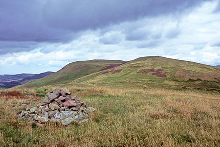
Grubbit Law & Hownam Law from Morebattle
Scottish Borders Walk
County/Area - Scottish Borders
Author - Lou Johnson
Length - 7.0 miles / 11.4 km Ascent - 1500 feet / 455 metres
Time - 5 hours 0 minutes Grade - moderate
Maps 

| Ordnance Survey Explorer OL16 | Sheet Map | 1:25k | BUY |
| Anquet OS Explorer OL16 | Digital Map | 1:25k | BUY |
Walk Route Description
Click image to see photo description.
This walk from Morebattle explores a grassy ridge linking Grubbit Law with Hownam Law. Despite their more height the views are wide ranging and include The Cheviot across the border in England. The route to Hownam Law is straightforward although the final descent requires careful navigation with the relevant OS 1:25k map proving useful.
Start from the centre of the Morebattle village (grid ref. NT771249) where limited on-street parking is available. After parking, walk east on the B6401 and continue past the Templehall Hotel on the right. At the next road junction bear right onto a minor signed to Hownam. The road climbs steeply before a gentle descent into the Kate Valley. At the next junction turn right (also signed to Hownam) and continue for 600 metres to reach a wooden footbridge on the left.
Cross the bridge and follow St. Cuthbert's Way to a gate. Almost immediately turn right onto a clear track. Where the track bends sharp left bear right off the track to join a grassy track with the fence on your right. Head up to the corner of a plantation and follow the St. Cuthbert's Way as it turns right and continue up to a stile (grid ref. NT787238). From here head east-northeast over rough ground to gain the summit of Grubbit Law (326 m.).
From Grubbit Law head east keeping to the high ground to cross a stile in a wall. Stay with the wall as it turns south crossing Cushat End. Continue with the wall towards Hownam Law. Pass through a gate in the first cross wall and continue to another gate in a cross wall. Continue to the summit of Hownam Law (449 m.) with its OS trig column. This was once the site of an important Iron Age hill fort although little remains of what must have been a sizeable structure.
To continue descend southwest and then west-northwest down the steep western flank of Grange Hill. The gradient soon eases, and you reach a grassy track heading north with a wall on your left. Go through a gate and head north with the wall on your left. Pass through another gate to join a track. Continue ahead, keeping Hownam Grange Farm to your left. Follow the farm access drive to the road. Turn right and continue to the next road junction, where your fork left to return to Morebattle.
Other walks nearby
| Walk 1201 | Black Hag from Kirk Yetholm | moderate | 8.5 miles |
| Walk 2299 | The Cheviot | moderate | 9.0 miles |
| Walk 1314 | Great Hetha and Elsdon Burn from Hethpool | easy/mod | 4.0 miles |
| Walk 3644 | Blackhaggs Rigg & Great Hetha from Hethpool | moderate | 9.6 miles |
| Walk 3646 | Hethpool, Sutherland Bridge & Great Hetha | moderate | 6.0 miles |
| Walk 3739 | Elsdonburn & Trowupburn from Hethpool | moderate | 8.2 miles |
| Walk 2169 | Chew Green & Upper Coquet Valley | easy/mod | 5.8 miles |
| Walk 2251 | Yearning Saddle & Brownhart Law | moderate | 7.8 miles |
| Walk 1894 | Burnhope Reservoir Circular | easy | 2.8 miles |
| Walk 1200 | Windy Gyle | moderate | 7.5 miles |
Recommended Books & eBooks
The Borders Abbeys Way
 Guidebook to the Borders Abbeys Way, a 68 mile circuit in the Scottish Borders, taking in 4 of Britain's grandest ruined medieval abbeys. Beginning and ending in Tweedbank, the route, which is described over 6 stages, is as rich in history as it is in pastoral charm. Relatively flat, it is suitable for people with a moderate level of fitness.
More information
Walking in the Southern Uplands
 Guidebook to 44 varied day walks and over 100 summits in the Southern Uplands of Scotland, stretching south-west from Edinburgh to the English border, including the Galloway and Pentland Hills. Between 2 and 29km, there is something for all seasons and all abilities in remote and rugged hill country.
More information
Messaging & Social Media
Message Walking Britain and follow the latest news.

Mountain Weather
Stay safe on the mountains with detailed weather forecasts - for iOS devices or for Android devices.