Avebury & Overton Down from Overton Hill
North Wessex Downs Walk
Region - North Wessex Downs
County/Area - Wiltshire
Author - Lou Johnson
Length - 7.5 miles / 12.2 km Ascent - 400 feet / 121 metres
Time - 4 hours 10 minutes Grade - easy/mod
Maps 

| Ordnance Survey Explorer 157 | Sheet Map | 1:25k | BUY |
| Anquet OS Explorer 157 | Digital Map | 1:25k | BUY |
| Ordnance Survey Landranger 173 | Sheet Map | 1:50k | BUY |
| Anquet OS Landranger 173 | Digital Map | 1:50k | BUY |
Walk Route Description
Click image to visit gallery of 6 images.
An energetic walk across the North Wessex Downs is combined with a visit to the ancient monuments in the small Wiltshire village of Avebury. The start for this walk is the free parking area at Overton Hill (grid ref. SU118680) on the north side of A4 west of Marlborough.
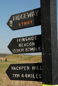
From the parking area walk uphill north along the Ridgeway. This ancient byway starts at Overton Hill and continues for some 87 miles to Ivinghoe Beacon in the Chilterns. After half a mile take the signed track on the left (grid ref. SU 118687). This descends gently to Manor Farm. Turn left on this lane and continue into Avebury where amongst other things you can explore the wonderful stone circle which is seen by experts as more important than Stonehenge.
After exploring the village return along the lane to manor farm (grid ref. SU110702). This leads across fields crossing a track leading left to Rutlands Farm. You pass Avebury Down Barn on the right with a small copse on the same side. Go straight across the tracks from East Farm and Middle Farm to reach Mill Lane (grid ref SU107726). Turn right here onto a signed bridleway and walk towards the Downs. You reach a t-junction (grid ref. SU115726) where you go left. The track then bear right and leads onto the main ridge of the downs and the Ridgeway (grid ref. SU124730).
Turn right along the Ridgeway. The views to the right are excellent. Reaching a junction of tracks and paths on Overton Down (grid ref. SU125708) it is worth reading the information board here which details some interesting facts about Overton Down and its use as a source of Sarsen Stones. Continue ahead walking gently downhill. You will see a number of sites on your right where burial mounds have been covered in trees. Known locally as 'hedgehogs', these are a prominent feature of the landscape hereabouts. You will soon be back at the start.
If you have time it is worth crossing the road and taking a look at the Sanctuary. There is an information board that explains the site.
Other walks nearby
| Walk 2812 | Avebury, West Kennett and Silbury Hill | easy/mod | 7.0 miles |
| Walk 3417 | Silbury Hill and West Kennett Long Barrow from Avebury | easy | 3.0 miles |
| Walk 3318 | Hackpen Hill & Overton Down | easy/mod | 9.5 miles |
| Walk 2377 | Highlights of Avebury | easy/mod | 8.8 miles |
| Walk 2339 | Milk Hill the highest point in Wiltshire | easy | 3.0 miles |
| Walk 1807 | The Southern Escarpment of the Marlborough Downs | easy/mod | 6.5 miles |
| Walk 2357 | Grey Wethers & Fyfield Down from Hackpen White Horse | easy/mod | 8.5 miles |
| Walk 1733 | Wessex Downs & Kennet & Avon Canal from Pewsey | easy/mod | 8.0 miles |
| Walk 3295 | Pewsey Hill and Fyfield Down | easy/mod | 9.0 miles |
| Walk 1928 | Pewsey Downs from Wootton Rivers | easy/mod | 8.0 miles |
Recommended Books & eBooks
Walking in the North Wessex Downs
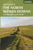 30 walking routes exploring the North Wessex Downs Area of Outstanding Natural Beauty (AONB). The routes are between 7km to 20km through this peaceful rolling chalk landscape covering parts of four counties: Berkshire, Hampshire, Wiltshire and Oxfordshire, with descriptions to reach the highest points in each one.
More information
The Kennet and Avon Canal
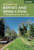 Guidebook to walking along the Kennet & Avon Canal. The 94 mile route from Reading to Bristol is split into 7 stages of fairly easy walking and includes the UNESCO World Heritage Site of Bath and Bristol's Floating Harbour. 20 circular walks are also included, ranging from 4¼ to 9 miles, taking in the best sections of the canal.
More information
Messaging & Social Media
Message Walking Britain and follow the latest news.

Mountain Weather
Stay safe on the mountains with detailed weather forecasts - for iOS devices or for Android devices.