Turkey Street to Crews Hill (London Borough of Enfield)
London Walk
County/Area - London
Author - Peter Smyly
Length - 9.0 miles / 14.6 km Ascent - 600 feet / 182 metres
Time - 5 hours 10 minutes Grade - moderate
Maps 

| Ordnance Survey Explorer 174 | Sheet Map | 1:25k | BUY |
| Anquet OS Explorer 174 | Digital Map | 1:25k | BUY |
| Ordnance Survey Landranger 166 | Sheet Map | 1:50k | BUY |
| Anquet OS Landranger 166 | Digital Map | 1:50k | BUY |
Walk Route Description
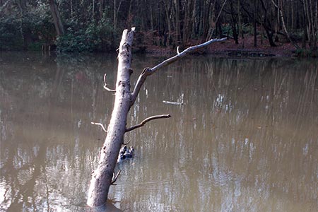
Click image to visit gallery of 6 images.
This London walk in Enfield (Section 17 of the London Outer Orbital Path) between Enfield Lock and Cockfosters is one of the more scenic sections of the LOOP. This walk includes part of section 17 between Turkey Street railway station and Strayfield Road. This is a linear route between two railway stations in the London Borough of Enfield in north London. Despite being in London, much of the route has a distinctly rural feel about it with parks, fields, woodland, country lanes, streams, farmland and a degree of undulation. Sections of it are liable to be both muddy and waterlogged so make sure you wear appropriate footwear.
From Turkey Street station on the London Overground, cross the road of the same name and walk along Winnington Road, shortly leaving this road on the right along a path that borders a cemetery on the left to cross a footbridge over the A10. The path continues on the other side and, from a route-finding point of view, at this stage it is simply a case of following the route ahead with London Loop way markers appearing occasionally.
The Turkey Brook appears on the right as you pass through Forty Hall Country Park and enter woodland with a pond on the left where occasional trees protrude from the water. The next road crossing marks a point where you reach the appropriately named Hilly Fields Park. Take the lower of the three footpaths and then leave the park via the second footbridge on the right, the path leading uphill to Strayfield Road. You say goodbye to the London Loop at this juncture which goes to the left past the church. For this route cross the busy main road ahead and follow the country lane opposite, Flash Lane, which later becomes a bridleway through woodland, Whitewebbs Wood. When you reach the busy Whitewebbs Road one option that avoids walking alongside the road is a bridleway, which is liable to be muddy, on the right. This emerges at a car park by a pub, the King and Tinker. Cross the road here to continue along a footpath leading to Cheshunt.
The sound of traffic from the nearby motorway can already be heard by the time you cross a stile and border the left field edge. Note - the section on the other side of the stile is especially liable to be muddy and waterlogged. Negotiating it without mishap may not be the end of your troubles either as there are more sections ahead liable to present similar conditions underfoot before the motorway is reached.
The motorway is crossed by a footbridge and the path continues ahead on the other side. On reaching a road, bear left and then almost immediately right. The route ahead passes Home Wood on the left. Follow this route as it contours round to the left and then right as it skirts field edges. Later a path skirts around Broadfield Farm on the right and continues along a road, later becoming a path, on the left. The point where you turn sharp right may not be immediately apparent when you get there with just a small circular way marker on a tree to indicate the route. If you have reached a metal gate ahead, you have gone too far and need to go back to find the turning. Once located and followed, you reach a road - turn left and follow this road as it bends round to the right and keep going straight ahead until turning left down Silver Street.
A sign here indicates that this is not a pedestrian route; however, it is shown as one on the Explorer map (Epping Forest and Lee Valley number 174). Follow this road - which has a view north towards Goffs Oak - until turning left down a country lane due south passing Woodgreen Farm. Leaving the farm behind, turn right at the next path junction (along Chain Walk) and left at the next crossroads of paths (along Burntfarm Ride). You are near the end of the walk now - the road ahead passes under the motorway. On reaching the next road, bear right and Crews Hill railway station appears on the right just before the railway bridge.
Other walks nearby
| Walk 1940 | Lea Valley from Enfield Lock to Bow | easy/mod | 12.5 miles |
| Walk 1723 | Broxbourne Circular via Roydon | moderate | 10.3 miles |
| Walk 3600 | Totteridge and Whetstone circular (London Borough of Barnet) | easy/mod | 8.7 miles |
| Walk 2747 | Nazeingwood Common from Epping Green | easy | 4.5 miles |
| Walk 3661 | Essendon & Little Berkhamsted Circular | easy/mod | 7.4 miles |
| Walk 3368 | Nazeing Circular from Epping Green | easy | 5.0 miles |
| Walk 1741 | Rye House circular via Roydon and Stanstead Abbots | easy/mod | 9.1 miles |
| Walk 1535 | Snaresbrook to Loughton (Epping Forest) | easy/mod | 8.0 miles |
| Walk 2586 | Epping to Chipping Ongar | easy/mod | 7.5 miles |
| Walk 1024 | Essendon to Bayford Circular | easy/mod | 10.0 miles |
Recommended Books & eBooks
Walking in London
 A guidebook to 25 walks in London's green spaces and nature reserves, covering both the city centre and Greater London area. Taking in woods and forests, parks and heaths, canals and rivers, the guide includes a wealth of information about some of the species you might encounter as well as the history and conservation of these areas.
More information
Messaging & Social Media
Message Walking Britain and follow the latest news.

Mountain Weather
Stay safe on the mountains with detailed weather forecasts - for iOS devices or for Android devices.