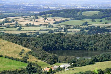
Gormire Lake from Sutton Bank National Park Centre
North York Moors Walk
Nat Park - North York Moors - North York Moors West
County/Area - North Yorkshire
Author - Lou Johnson
Length - 3.4 miles / 5.5 km Ascent - 800 feet / 242 metres
Time - 2 hours 30 minutes Grade - easy/mod
Maps 

| Ordnance Survey Explorer OL26 | Sheet Map | 1:25k | BUY |
| Anquet OS Explorer OL26 | Digital Map | 1:25k | BUY |
Walk Route Description
Click image to see photo description.
This short North York Moors walk starts from the National Park Centre at the top of Sutton Bank just off the A170. The route follows a section of the Cleveland Way with some excellent views down to Gormire Lake and across the Vale of York. The route then descends to Gormire Lake and follows a path to almost complete a circuit. The walk continues by climbing up through woodland back to the start. A good sense of direction is needed in places to complete this walk.
There are many parking opportunities at or near the National Park Centre (grid ref. SE516831). I parked in the main car park in front of the visitor centre. After parking walk through the car park to the exit. There is a one-way system in the car park so just follow the arrows to the exit. Turn left leaving the car park and walk as far as some parking ticket machines. Just before the machines, cross the road to follow a path on the other side of the road.
Follow this path to reach another parking area. Turn sharp left and at the next path junction turn left again. This clear path leads to the Cleveland Way (by a sign pointing back to the NP Centre). Turn right onto the Cleveland Way. Continue past a wooden viewing platform raised above the path on your right and continue with glimpses of Gormire Lake down to your left. You reach a 3-way path junction. The return route brings you back to this point. Continue straight ahead on the Cleveland Way. Soon the views are more open to the left and on a clear day you can literally see for miles. Continue on the main path using the left-hand path of the two. You reach a wooden bench on your left. Continue along the Cleveland Way soon walking above Whitestone Cliff, which is visible as you approach. The next landmark is another seat and an information board. Just beyond this you reach another footpath sign (right hand path leads to Dialstone Farm (grid ref. SE507838).
At the next fingerpost leave the Cleveland Way and turn sharp left following the path to Thirlby Bank. This path descends through woods and with careful navigation leads you down towards Southwood Lodge. During the descent the path twists and turns with several smaller paths causing confusion. Just before Southwood Lodge, turn left onto a signed bridleway (grid ref. SE503837). After 200 metres bear right onto a path, which leads you down to the shore of Gormire Lake. (You can shorten the route by continuing ahead on the bridleway.)
Turn right and follow the path along the shore (lake on your left). Walk around the lake, completing three-quarters of a circuit to re-join the bridleway. Two hundred metres after joining the bridleway, turn right up a path into woodland. (if you have taken the short cut, turn left here.) This soon joins another path where you bear right and continue to climb steadily across Sutton Brow to regain the Cleveland Way. Turn right and continue to the road. Go straight across and at a large wooden sign turn left and follow the path back to the start.
Other walks nearby
| Walk 1498 | Kilburn White Horse, Cold Kirby, Murton, & Sutton Bank | moderate | 14.0 miles |
| Walk 2566 | Rievaulx Abbey from Kilburn, near Thirsk | mod/hard | 15.0 miles |
| Walk 1524 | Cold Kirby, Rievaulx Bridge & Wass | moderate | 12.5 miles |
| Walk 2702 | Ampleforth, Shallow Dale, Yearsley Moor & Wilderness | moderate | 9.5 miles |
| Walk 1622 | Hawnby, Bilsdale West and Wetherhouse Moors | moderate | 8.3 miles |
| Walk 1525 | Beck Dale & Rievaulx from Helmsley | moderate | 9.8 miles |
| Walk 1920 | Rievaulx Moor from Cowhouse Bank | moderate | 9.5 miles |
| Walk 1704 | Oswaldkirk, Nunnington & Harome circular | moderate | 11.5 miles |
| Walk 1473 | Hollin Hill to Square Corner by the Cleveland Way | moderate | 9.5 miles |
| Walk 1497 | High Paradise around Arden Great Moor from Square Corner | moderate | 14.3 miles |
Recommended Books & eBooks
The Cleveland Way Map Booklet
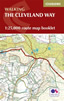 Map booklet of the Cleveland Way National Trail, a 177km (110 mile) walk around the North York Moors National Park. This booklet is included with the Cicerone guidebook to the Cleveland Way and the Yorkshire Wolds Way, and shows the full route of the Cleveland Way on Ordnance Survey 1:25,000 maps.
More information
Trail and Fell Running in the Yorkshire Dales
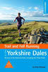 Guidebook to 40 of the best trail and fell runs in the Yorkshire Dales National Park. Ranging from 5 to 24 miles, the graded runs start from bases such as Ribblehead, Dent, Sedbergh, Malham and Grassington and take in the region's diverse delights, from castles and waterfalls to iconic mountains such as Whernside, Ingleborough and Pen Y Ghent.
More information
Messaging & Social Media
Message Walking Britain and follow the latest news.

Mountain Weather
Stay safe on the mountains with detailed weather forecasts - for iOS devices or for Android devices.