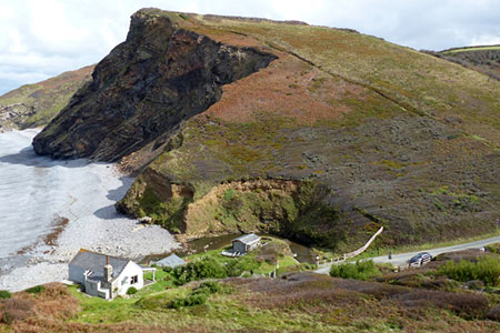
Dizzard Point, Millook from Penhalt Cliff
Cornwall AONB Walk
Region - Cornwall AONB
County/Area - Cornwall
Author - Lou Johnson
Length - 6.0 miles / 9.8 km Ascent - 1200 feet / 364 metres
Time - 4 hours 10 minutes Grade - moderate
Maps 

| Ordnance Survey Explorer 111 | Sheet Map | 1:25k | BUY |
| Anquet OS Explorer 111 | Digital Map | 1:25k | BUY |
Walk Route Description
Click image to see photo description.
This walk from near Millook on the north Cornwall Coast explores a fine section of coast and the wooded Millook Water valley. The route follows paths, including a section of the South West Coast Path, with a section along a quiet lane. Highlights of the walk are many. They include the mature broadleaf woodland on the inland section of the walk which contrasts with the high cliffs between Dizzard Point and Penhalt Cliff. As with many coastal walks, there are several ascents and descents on the coastal path.
The walk starts from the small car park for the viewpoint at Penhalt Cliff (grid ref. SS189005). After parking exit the car park and walk west to take the South West Coast Path by in the fingerpost. Follow the path as it descends steeply to the road at Millook. Turn right, follow the road round a sharp left-hand bend and take the first footpath on the left through a gate. The clear path heads up the valley to reach a ford with adjacent footbridge (grid ref. SX182992). Turn right after crossing the bridge and continue upstream through woodland with Millook Water now to your right.
Leaving the woodland crosses afield to reach a stile. Cross the stile and follow the track (signed Dizzard and Trengaynor) passing a cottage on your left. Turn right through a gate, cross a stile, and continue over a footbridge. Continue up steps and turn left (as signed). The path meanders through beautiful woodland and then turns right up a side valley climbing steeply. Reaching the top of this side valley, pass through gate and turn right along a track. You soon pass Trengaynor to reach a lane (grid ref. SX169980).
Turn right and follow the lane for 400 metres where you turn left onto a concrete drive (grid ref. SX168984) with the footpath sign (Coast Path) hidden in the hedge by a post box. The track leads into a path which follows the right-hand edge of a field. Continue through trees over a footbridge into the next field. Again, keep to the right-hand edge with the hedge on your right. Go straight across a track (grid ref. SX163987) and continue ahead to the South West Coast Path.
With the sea on your left, turn right and climb up to the trig column on Dizzard Point (549 m.). The path then descends over Bynorth Cliff, detours up a side valley to return to the cliff tops. A steady descent leads to the road at Millook. Turn left along the road and continue uphill before taking the first footpath on the left. Climb the steps and uphill to reach the start.
Other walks nearby
| Walk 1076 | Dizzard Point & Crackington Haven | moderate | 8.0 miles |
| Walk 2730 | St Gennys & Castle Point from Crackington Haven | easy/mod | 3.0 miles |
| Walk 2731 | Cambeak & Crackington Haven | easy/mod | 4.3 miles |
| Walk 1996 | Woodford & Hollygrove Wood | easy/mod | 5.1 miles |
| Walk 3207 | Knap Head to Mansley Cliff | moderate | 8.0 miles |
| Walk 1788 | Welcombe Mouth and Darracott | moderate | 6.0 miles |
| Walk 1029 | Tintagel to Boscastle | moderate | 9.0 miles |
| Walk 1808 | Brown Willy, exploring Cornwall's highest Tors | easy/mod | 4.0 miles |
| Walk 3279 | Tors of Bodmin Moor | moderate | 10.0 miles |
| Walk 3208 | Stoke & Hartland Quay | moderate | 6.4 miles |
Recommended Books & eBooks
South West Coast Path Map Booklet - St Ives to Plymouth
 Map of part of the southern section of the 630 mile (1014km) South West Coast Path National Trail. Covers the trail from St Ives to Plymouth along the west Cornwall and Devon coastline. This convenient and compact booklet of Ordnance Survey 1:25,000 maps shows the route, providing all of the mapping you need to walk the trail in either direction.
More information
The South West Coast Path
 Guidebook to walking the entire South West Coast Path National Trail. The route runs for 630 miles from Minehead to Poole along the north Devon, Cornish, south Devon and Dorset coastline. Divided into 45 stages, this long-distance coastal trek could be completed within 4 weeks, or walked in sections. Guide includes maps and essential information.
More information
Messaging & Social Media
Message Walking Britain and follow the latest news.

Mountain Weather
Stay safe on the mountains with detailed weather forecasts - for iOS devices or for Android devices.