The Fairfield Horseshoe from Ambleside
Lake District Walk
Nat Park - Lake District - Lake District Eastern Fells
Wainwrights - Dove Crag, Fairfield, Great Rigg, Hart Crag, Heron Pike, High Pike, Low Pike, Nab Scar
County/Area - Cumbria
Author - Lou Johnson
Length - 11.0 miles / 17.9 km Ascent - 3400 feet / 1030 metres
Time - 8 hours 50 minutes Grade - mod/hard
Maps 

| Ordnance Survey Explorer OL5 | Sheet Map | 1:25k | BUY |
| Anquet OS Explorer OL5 | Digital Map | 1:25k | BUY |
| Ordnance Survey Explorer OL7 | Sheet Map | 1:25k | BUY |
| Anquet OS Explorer OL7 | Digital Map | 1:25k | BUY |
| Ordnance Survey Landranger 90 | Sheet Map | 1:50k | BUY |
| Anquet OS Landranger 90 | Digital Map | 1:50k | BUY |
Walk Route Description
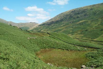
Click image to visit gallery of 3 images.
The Fairfield horseshoe is a popular Lake District walk starting and finishing in Ambleside (Grid ref. NY 375045). A shorter version is detailed in walk 1170. From the centre of Ambleside take the Kirkstone Road for a short way turning down the first lane on the left. This leads to Low Sweden Bridge from where the views of the Fells begin to improve. The onward path to Low Pike is well-trodden and you soon find yourself alongside the ridge wall. This leads onwards over High Pike and onto Dove Crag. As you climb, the views on both sides are excellent and improve with each step.
Although you are now in the high fells, progress is easy. Although you are climbing most of the time there is nothing too strenuous and you feel as though you are covering a lot of ground. By the time you reach Dove Crag, you have earned a rest, and this is an excellent place to see the majority of the Fairfield horseshoe. Suitably refreshed head on to Hart Crag where the view north opens out with St Sunday Crag dominating the view. The ascent is nearly over and after dropping off the northern side of Hart Crag to Link Hause a steep rocky upward pull brings you onto Fairfield.
As the name suggests, this mountain is a grassy plateau. However on its north eastern flanks there are some superb crags and rather than follow the main path it is better to keep to your right following the narrow trod which skirts around the top of the cliffs. Besides an excellent view into Deepdale, you are able to appreciate the full extent of Fairfield's rocky aspect. Suitably impressed, you should arrive at the summit cairn from where the far ranging views are excellent. However because of the domed nature of the plateau it is better to explore a little with a short walk north to inspect Cofa Pike and Grisedale Hause particularly rewarding.
Having reached the highest point of the walk it is downhill almost all the way back to Grasmere. In poor visibility do be careful to take the correct path off Fairfield as it can be a confusing place in low cloud. Keeping on the main path to Great Rigg you will find it easy to keep a good pace with an excellent Lakeland panorama ahead. Reaching the cairn on Great Rigg descend taking the main path to Heron Pike.
From this last major 'top' of the route continue south to Nab Scar from where there is a steep descent into Rydal. Keep to the north side of Rydal Hall and follow the drive through pleasant parkland to meet the main road just outside Ambleside. Turn left along the main road and you will be back at the start.
Other walks nearby
| Walk 2026 | Loughrigg from Pelter Bridge near Rydal | easy/mod | 4.0 miles |
| Walk 3034 | Red Screes & Other Fells from Ambleside | mod/hard | 10.0 miles |
| Walk 3697 | Loughrigg Fell from Skelwith Bridge | easy/mod | 4.5 miles |
| Walk 1823 | Fairfield Horseshoe & Loughrigg from High Close | mod/hard | 14.0 miles |
| Walk 1472 | Alcock Tarn & Rydal Water | easy/mod | 7.0 miles |
| Walk 1565 | Rydal Water & Grasmere circular | easy/mod | 6.0 miles |
| Walk 1682 | Rydal Water & Grasmere | easy/mod | 5.5 miles |
| Walk 2715 | Skelwith Bridge & Loughrigg | easy/mod | 5.5 miles |
| Walk 1684 | Lingmoor Fell & Langdale | easy/mod | 7.0 miles |
| Walk 1141 | Elterwater circular | easy/mod | 4.0 miles |
Recommended Books & eBooks
Walking the Lake District Fells - Wasdale
 Part of the Walking the Lake District Fells series, this guidebook covers a wide range of routes to 25 Lakeland summits that can be climbed from the Wasdale, Eskdale and Ennerdale valleys, with highlights including Scafell Pike, Great Gable and Pillar. Suggestions for longer ridge routes are also included.
More information
Walking the Lake District Fells - Mardale and the Far East
 Part of the Walking the Lake District Fells series, this guidebook covers a wide range of routes to 36 Lakeland summits that can be climbed from the Ullswater, Haweswater, Troutbeck, Kentmere and Longsleddale valleys, with highlights including High Street, Place Fell and the Kentmere fells. Suggestions for longer ridge routes are also included.
More information
Messaging & Social Media
Message Walking Britain and follow the latest news.

Mountain Weather
Stay safe on the mountains with detailed weather forecasts - for iOS devices or for Android devices.