Walk 1021 - printer friendly version
Milldale & Hall Dale Walk
Author - Lou Johnson
Length - 5.0 miles / 8.1 km
Ascent - 500 feet / 152 metres
Grade - easy/mod
Start - OS grid reference SK131556
Lat 53.097447 + Long -1.8073102
Postcode DE6 2FY (approx. location only)
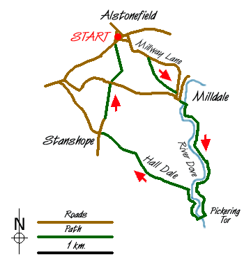
This Peak District walk starts from the car park (Grid ref. SK 131556) located in the centre of the pleasant village of Alstonefield with its pub, the George Inn. Head south out of the village past the chapel and along Millway Lane to locate the footpath on the right (Grid ref SK 134553). This leads over fields down to the busy hamlet of Milldale beside the River Dove.
Cross the footbridge at the south end of the village by the toilets and follow the main path down the River Dove. Despite its popularity this is still a pleasant stretch of Dovedale with high limestone crags on either side. Continue down Dovedale to the first footbridge located between Pickering Tor on the eastern side of the river and Ilam Rock on the western side. Cross the footbridge and turn north retracing your route for about 400 yards where you turn left up Hall Dale.
With wooded slopes on one side and open grassland on the other this is a pleasant dale and typical of the "White Peak" with dry stone walls adding that essential character of the area. Continue up Hall Dale to join Pasture Lane, which leads into a road at Stanshope. Turn right here and walk north along this track to drop down to another road at Dale Bottom. Cross the road and take the footpath opposite. The first section involves a sharp uphill section before levelling off for the final section through fields to Alstonefield and the start of the walk.
Messaging & Social Media
Message Walking Britain and follow the latest news.

Mountain Weather
Stay safe on the mountains with detailed weather forecasts - for iOS devices or for Android devices.