The Corpse Road and Selside Pike from Mardale
Lake District Walk
Nat Park - Lake District - Lake District Far Eastern Fells
Wainwrights - Branstree, Selside Pike
County/Area - Cumbria
Author - Lou Johnson
Length - 6.0 miles / 9.8 km Ascent - 1830 feet / 555 metres
Time - 4 hours 50 minutes Grade - moderate
Maps 

| Ordnance Survey Explorer OL5 | Sheet Map | 1:25k | BUY |
| Anquet OS Explorer OL5 | Digital Map | 1:25k | BUY |
| Ordnance Survey Landranger 90 | Sheet Map | 1:50k | BUY |
| Anquet OS Landranger 90 | Digital Map | 1:50k | BUY |
Walk Route Description
Click image to visit gallery of 3 images.
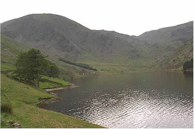
The Lakleand mountains close in as you drive along the shores of Haweswater towards Mardale Head. There is a car park at the end of the road but it is better to park where the Old Corpse Road leaves the road (grid ref. NY 479118). For many years before the construction of Haweswater Reservoir the village of Mardale buried its dead in the village of Shap. The first part of this walk traces the steps of these sombre processions as they made their way over the shoulder of Selside Pike into Swindale.
You may be surprised by the relatively large number of people armed with high powered binoculars and telephoto lenses in the Mardale area. The reason for all this activity is the last pair of breeding Golden Eagles in England who nest in the crags above Riggindale. This fine u-shaped valley is on the opposite side of the reservoir from where you have parked your car. From mid-April onwards there is much excitement as the prospect of chicks gets closer.
Take the path which zig-zags upwards from the road, heading roughly east as it climbs rapidly. At each turn the view across the Lake District improves, giving a good excuse to pause to catch your breath! Soon the initial steepness is over and the hardest part of the walk is behind you even though you still have some height to gain. The path is clear, helped by marker posts at regular intervals. Quite quickly you reach the summit and it is here you leave the Corpse Road to turn south on a less-distinct path to the summit of Selside Pike.
It is better to trend left on this section as there are excellent views down into lonely Swindale and across to the Pennines. Reaching the summit of Selside Pike, you are rewarded with a fine panorama across to the High Street Range in the west. Less visited, the wild Shap Fells and the Howgills can be seen to the east.
The next objective is Branstree easily reached by following the path along the western side of the fence. It is easy going despite the occasional "soft" spot. You will notice on the OS map that a pillar is marked. This is worth a detour from the main path. Erected by the engineers building the Long Sleddale aqueduct, it is a reminder of the days when Mardale was a hive of construction activity as the reservoir gradually took shape.
A short way before the summit of Branstree a couple of large "beehive" cairns provide an interesting place to take in the view before reaching the actual "top". The reward for all your effort is laid out to the west. High Street, Harter Fell and Mardale Ill Bell are the principal fells in view with the tarns of Blea Water and Small Water adding interest to the scene. It is one of the finest panoramas in the far eastern Fells.
The start of the final descent of the day is always a moment of sadness as you realise that you'll have to wait for another day to visit to tops. The descent from Branstree is easy, following the fence down to Gatescarth Pass where the main bridle-path is joined for the onward route down to Mardale Head. To your left, the wonderful craggy east face of Harter Fell throws out a challenge for another day. On reaching the car park take the path that skirts the reservoir rather than follow the road and quite soon you are back at your car.
The walk as described took just over four hours at our leisurely pace. For a longer day in the hills it is quite feasible to continue from Gatescarth Pass over Harter Fell and down to Nan Bield Pass, returning from there to Mardale Head Car Park. This will add around 600 feet of ascent and a couple of miles of very interesting walking.
Other walks nearby
| Walk 1109 | Harter Fell & Nan Bield Pass | moderate | 4.5 miles |
| Walk 1269 | High Street & Kidsty Pike | moderate | 7.5 miles |
| Walk 1462 | Mardale Head horseshoe | moderate | 8.0 miles |
| Walk 3033 | Tarn Crag & Harrop Pike from Sadgill | moderate | 5.5 miles |
| Walk 1147 | Longsleddale and Kentmere Pike | moderate | 8.0 miles |
| Walk 1228 | Thornthwaite Beacon & High Street | moderate | 6.5 miles |
| Walk 1959 | Gray Crag and Pasture Beck from Hartsop | moderate | 5.5 miles |
| Walk 2585 | Hartsop Dodd, Stony Cove Pike, High St. & The Knott | mod/hard | 10.0 miles |
| Walk 3309 | Hartsop, Hartsop Dodd, Stony Cove Pike & Kirkstone Pass | moderate | 8.5 miles |
| Walk 1110 | Angletarn Pikes | moderate | 7.0 miles |
Recommended Books & eBooks
Walking the Lake District Fells - Mardale and the Far East
 Part of the Walking the Lake District Fells series, this guidebook covers a wide range of routes to 36 Lakeland summits that can be climbed from the Ullswater, Haweswater, Troutbeck, Kentmere and Longsleddale valleys, with highlights including High Street, Place Fell and the Kentmere fells. Suggestions for longer ridge routes are also included.
More information
The Cumbria Way
 A guidebook to the 73 mile Cumbria Way, an easy long-distance walk though the heart of the Lake District National Park, from Ulverston in the south to Carlisle in the north, with good transport links to either end. The route is largely low-level but this guide offers alternative mountain days to climb some of the famous fells en route.
More information
Messaging & Social Media
Message Walking Britain and follow the latest news.

Mountain Weather
Stay safe on the mountains with detailed weather forecasts - for iOS devices or for Android devices.