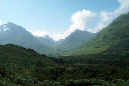
Pap of Glencoe from Glencoe Village
Highland Walk
County/Area - Highland - Fort William Lochaber
Author - Lou Johnson
Length - 4.2 miles / 6.8 km Ascent - 2200 feet / 667 metres
Time - 4 hours 20 minutes Grade - moderate
Maps 

| Ordnance Survey Explorer 384 | Sheet Map | 1:25k | BUY |
| Anquet OS Explorer 384 | Digital Map | 1:25k | BUY |
| Ordnance Survey Landranger 41 | Sheet Map | 1:50k | BUY |
| Anquet OS Landranger 41 | Digital Map | 1:50k | BUY |
Walk Route Description
Click image to visit gallery of 5 images.
Glencoe is noted for being the site of the infamous massacre and is always busy with visitors from every corner of the world. Preoccupied with the grander mountain scenery on either side of the Glen, many will still have taken note of Sgorr na Ciche (or the Pap of Glencoe) with its distinctive shape and isolated position. Rising steeply behind the village of Glencoe, it is the most westerly summit of the famous Aonach Eagach ridge. Although of modest height (2434ft - 742m) when compared to its more illustrious neighbours, it is a perfect objective for a short day in the mountains, providing excellent views in all directions except to the east.
After parking in the village (taking care not to cause an obstruction) head along the lane running south-east from the village towards the Youth Hostel and the Clachaig Inn. Stay on the lane until the end of the forested area on your left. Go through the gate (grid ref. NN111585) and head uphill northeast on a track, taking the obvious right fork to contour across the hillside. Cross two streams, occupying gullies visible from the valley, and just after the second take the path which heads steeply uphill beside the stream. Just above the wall (marked on the 1:25000 map) a less obvious path continues to follow the stream. You can take this but the preferred route is to take the wider path that makes a long upward traverse to the east followed by a similar traverse to the west.
Reaching the col at just under 2000ft all the hard work is over and you can begin to enjoy the ever improving views. From the col the path rises across the eastern face of the summit cone. Some very mild scrambling is needed to eventually reach the interesting summit with its obligatory cairn. From here the view can be appreciated at leisure. To the north the Mamores and Ben Nevis dominate whilst the big hills to the south of Glencoe form a spectacular panorama. Across Loch Linnhe to the west lie the less-visited peaks of Ardgour. Everywhere you look there are hills - providing hundreds of reasons to return and explore some more.
Sadly all good things come to an end and the descent follows your upward route. However if you are full of energy, the walk can be extended by returning to the col and then exploring the Aonach Eagach ridge, which runs eastwards. For those not familiar with the area, this ridge involves some difficult and exposed scrambling although most walkers can proceed at least as far as Sgurr nam Fiannaidh without too much difficulty. If you want to explore further then some research on the problems likely to met should be done before you start the walk!
Other walks nearby
| Walk 3118 | Sgor na h'Ulaidh from Achnachon, Glen Coe | mod/hard | 8.0 miles |
| Walk 2955 | Ridges & peaks of Bidean Nam Bian | very hard | 10.5 miles |
| Walk 2554 | The Lost Valley, Glen Coe | easy/mod | 4.2 miles |
| Walk 3251 | Bidean nam Bian via Stob Coire nan Lochan, Glencoe | hard | 5.0 miles |
| Walk 1496 | WHW - Day 6 - Kinlocheven to Fort William | moderate | 15.0 miles |
| Walk 3106 | Binnein Mor from Kinlochleven | hard | 10.2 miles |
| Walk 1039 | Am Bodach and Stob Coire a' Chairn | mod/hard | 9.5 miles |
| Walk 1094 | Blackwater Reservoir | moderate | 11.5 miles |
| Walk 2808 | Buachaille Etive Beag, Glen Coe | hard | 9.0 miles |
| Walk 3303 | Mamores Ridge - Stob Ban, Am Bodach and Sgurr an Iubhair | hard | 9.0 miles |
Recommended Books & eBooks
Great Mountain Days in Scotland
 Inspirational guidebook to 50 challenging routes for mountaineers, scramblers, hillwalkers and fell runners, many long enough to backpack over 2 days, especially in winter (12 to 25 miles). A mix of classic routes and unsung gems across Scotland from Galloway to the Outer Hebrides in widely differing wild landscapes. With customised OS mapping.
More information
Skye's Cuillin Ridge Traverse
 This 2-volume set provides all the information required to complete the main ridge traverse on Skye's Black Cuillin. Strategy, gear, training, navigation and logistics are covered, and 10 classic scrambles are described. A lightweight second guidebook gives the scrambler detailed maps, topos and route description for the ridge traverse itself.
More information
Messaging & Social Media
Message Walking Britain and follow the latest news.

Mountain Weather
Stay safe on the mountains with detailed weather forecasts - for iOS devices or for Android devices.