Y Llethr & Diffwys from Dyffryn Ardudwy
Snowdonia/Eryri Walk
Nat Park - Snowdonia - Rhinogs
County/Area - Gwynedd
Author - Lou Johnson
Length - 11.5 miles / 18.7 km Ascent - 3075 feet / 932 metres
Time - 8 hours 50 minutes Grade - mod/hard
Maps 

| Ordnance Survey Explorer OL18 | Sheet Map | 1:25k | BUY |
| Anquet OS Explorer OL18 | Digital Map | 1:25k | BUY |
| Ordnance Survey Landranger 124 | Sheet Map | 1:50k | BUY |
| Anquet OS Landranger 124 | Digital Map | 1:50k | BUY |
Walk Route Description
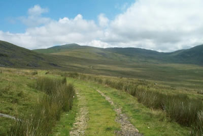
Click image to visit gallery of 9 images.
This lengthy circuit of the southern Rhinogs offers a great day in the hills. In contrast to the northern peaks of the range, which are rugged and rocky, this hike takes in the smoother but no less interesting peaks of Diffwys and Y Llethr.
The start of this Snowdonia (Eryri) walk is a small car park (grid ref SH603230) at the end of the lane leading to Gors y Gedol Hall from the A496 Barmouth to Harlech road just north of the village of Tal-y-bont. After parking go through the gate and follow the track heading east. This track, after a pair of right angled bends, reaches open country with the rounded shape of Moelfre on your left. Stay with the main track, ignoring the right fork that leads down to Pont Scethin. An indistinct path forks left (grid ref. 635242) and this heads up to the col on the eastern side of Moelfre.
You will soon pick up a more obvious path and this leads up to a wall which is followed for some way as it climbs steadily towards the first objective - the rounded summit of Y Llethr. As you climb the views improve rapidly and reaching a junction of walls turn left to climb steeply northwards to the cairn that marks the summit. For the best views continue over the top towards Rhinog Fach and you will find some rocks that offer grandstand views over Llyn Hywel to the rugged northern Rhinogs.
Retrace your steps past the summit and drop down to the wall junction mentioned above. With the wall on your left head roughly south along the top of Crib-y-rhiw where steep crags plunge to the wide valley below. The undulating path meanders through pleasant rocky outcrops before climbing more seriously to the summit of Diffwys.
If you are lucky and the weather is good then you will be rewarded with a superb view across the Mawddach estuary to Cadair Idris with the rarely visited summit of Y Garn also in view. Stay with the wall as you head south from the trig point turning west and staying with the wall over smooth upland to an intermediate spot height of 642 metres. Continue on the ridge path crossing a wall to reach a path that heads north down towards Pont Scethin. In bad visibility this may be hard to find. However at the point where the descending path meets the ridge path, there is a gate and a stile in the wall, and a cairn marking the descent about 10 yards to the right of the path.
This path was apparently the old Dolgellau to Harlech road although it is hard to imagine a coach and horses crossing this landscape in bad weather. The descent to Pont Scethin is straightforward and after crossing this old bridge you are soon back on the track you used for the outward sector of this walk. All that remains is steady plod back to the car park.
As with many mountain hikes this is one to save for fine weather. The views are without doubt some of the best in Southern Snowdonia (Eryri) with a variety of landscape seen on few walks. In addition there are many areas of water which add interest to the views.
Other walks nearby
| Walk 1746 | Bwlch y Rhiwgyr & Pont Scethin | moderate | 9.8 miles |
| Walk 1194 | Bwlch Drws-Ardudwy | easy | 4.5 miles |
| Walk 1644 | Cregennen Lakes | moderate | 11.0 miles |
| Walk 1647 | Mawddach Bridge and Arthog | easy | 5.4 miles |
| Walk 3229 | Mawddach circular | moderate | 9.0 miles |
| Walk 2450 | Llynnau Cregennen & Mawddach Estuary | moderate | 8.4 miles |
| Walk 1191 | Rhinog Fawr & Gloyw Lyn from Cwm Bychan | mod/hard | 5.0 miles |
| Walk 1851 | Cregennen Lakes & Pared y Cefn-hir | easy/mod | 2.5 miles |
| Walk 2544 | Rhinog Fach circular | moderate | 8.0 miles |
| Walk 1036 | Rhinog Fach & Y Llethr | moderate | 9.0 miles |
Recommended Books & eBooks
The Wales Coast Path
 A single guidebook to walking the whole Wales Coast Path - 1400km (870 miles) the length of Wales from Chester to Chepstow, including Anglesey, described in 57 stages. The route passes through the Snowdonia and Pembrokeshire National Parks and many AONBs and can be linked with the Offa's Dyke Path for a complete circuit of Wales.
More information
Great Mountain Days in Snowdonia
 Inspirational guidebook to 40 great mountain day walks and scrambles in Snowdonia. Inspirational routes for all abilities across the National Park with routes up Snowdon and Moel Eilio, the Glyderau, the Carneddau, Eifionydd, Siabod and the Moelwynion, Rhinogydd (the Harlech Dome), Migneint and the Arans and Cadair Idris and the Tarrens.
More information
Messaging & Social Media
Message Walking Britain and follow the latest news.

Mountain Weather
Stay safe on the mountains with detailed weather forecasts - for iOS devices or for Android devices.