Hadrian's Wall & Steel Rigg
Northumberland Walk
Nat Park - Northumberland
County/Area - Northumberland County
Author - Lou Johnson
Length - 8.0 miles / 13 km Ascent - 1250 feet / 379 metres
Time - 5 hours 20 minutes Grade - moderate
Maps 

| Ordnance Survey Explorer OL43 | Sheet Map | 1:25k | BUY |
| Anquet OS Explorer OL43 | Digital Map | 1:25k | BUY |
| Ordnance Survey Landranger 86 | Sheet Map | 1:50k | BUY |
| Anquet OS Landranger 86 | Digital Map | 1:50k | BUY |
| Ordnance Survey Landranger 87 | Sheet Map | 1:50k | BUY |
| Anquet OS Landranger 87 | Digital Map | 1:50k | BUY |
Walk Route Description
Click image to visit gallery of 5 images.
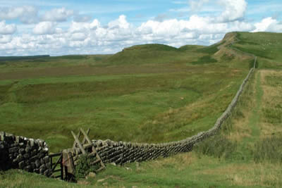
Hadrian's Wall is one of the great monuments to the Roman Occupation of Britain. Had it not been for subsequent inhabitants of the area using the wall as an easy source of building stone, there might have been at least some sections that retained their original height. However despite this "vandalism", enough remains to give visitors an excellent idea of what this northern outpost of the Roman Empire was actually like.
First of all a warning! This should be an easy walk but it does involve a considerable amount of ascent/descent and requires much more energy than you might think! Apart from the immediate area around Housesteads, which was quite busy, there were few people on the route and you could enjoy the Wall at leisure.
Park at the Steel Rigg car park (grid ref. NY750676). Return to the lane and turn right. After a short way there is a signed footpath on the right and you need to follow this right of way as it crosses fields past Peatrigg and Long Side to reach a path junction just north of Hotbank Farm. Follow the farm track a short way northeast before waymarks lead you on across more fields towards a small plantation (easiest route is around it rather through it as waymarked!) to reach the Wall at King's Wicket (grid ref.NY798694).
With the easiest section behind you, the switchback route now follows the Wall back to Steel Rigg car park for a distance of approximately four miles. This section is some of the best preserved and does benefit from including Vercovicium Fort (Housesteads) en-route. There are many better qualified people to inform you of the details of the Wall but suffice to say it is very impressive. The remains (mostly foundations) at Housesteads are remarkable with much to see and investigate. As you walk perhaps you should try to imagine what it was like to be stationed here in winter after enjoying the Mediterranean warmth of Italy!
Leaving Housesteads the route switchbacks up and down as it follows the most advantageous contours of the natural escarpment. I particularly liked the section along the crest of Hotbank Crags and the final stretch above Crag Lough and along Peel Crags. Both these sections are very enjoyable and enable you to get a feel for the area besides enjoying the history.
In conclusion this walk is a must for anyone visiting Northumberland ... if only history was as interesting at school!
Other walks nearby
| Walk 3404 | Hadrian's Wall - Cawfields to Steel Rigg | easy/mod | 3.5 miles |
| Walk 1677 | Peel Crags & Winshield Crags from Vindolanda | easy/mod | 7.8 miles |
| Walk 2671 | Hotbank Crags & Housesteads from Vindolanda | easy | 5.3 miles |
| Walk 3331 | Cragend & Crow Crags from Housesteads | easy/mod | 8.4 miles |
| Walk 3343 | Hadrian's Wall, Walltown Crags & Aesica | easy/mod | 5.0 miles |
| Walk 2803 | Hadrian's Wall and Haughton Common | hard | 20.0 miles |
| Walk 1786 | Hadrian's Wall & Simonburn circular | easy/mod | 6.8 miles |
| Walk 1987 | Allendale Town Circular | easy/mod | 6.6 miles |
| Walk 1477 | Bellingham to Kiln Rigg by Pennine Way Circular | moderate | 14.3 miles |
| Walk 1478 | Ladyhill to Bellingham circular | moderate | 16.0 miles |
Recommended Books & eBooks
The Pennine Way - the Path, the People, the Journey
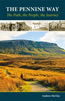 A portrait of the The Pennine Way, Britain's oldest and best known long-distance footpath, stretching 268 miles from the Peak District to the Scottish Borders. This personal, thoughtful and often humorous story of the path's remarkable history, includes the experiences of walkers and local characters on this exhilarating and complex path.
More information
Pennine Way Map Booklet
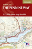 Map of the 270 miles (435km) Pennine Way National Trail, between Edale in the Peak District and Kirk Yetholm in the Scottish Borders. This booklet is included with the Cicerone guidebook to the trail, and shows the full route on Ordnance Survey 1:25,000 maps. This popular long-distance route typically takes three weeks to complete.
More information
Messaging & Social Media
Message Walking Britain and follow the latest news.

Mountain Weather
Stay safe on the mountains with detailed weather forecasts - for iOS devices or for Android devices.