The Thames Path Putney to Barnes
London Walk
County/Area - London
Author - Lou Johnson
Length - 4.0 miles / 6.5 km Ascent - 20 feet / 6 metres
Time - 2 hours 0 minutes Grade - easy
Maps 

| Ordnance Survey Explorer 161 | Sheet Map | 1:25k | BUY |
| Anquet OS Explorer 161 | Digital Map | 1:25k | BUY |
| Ordnance Survey Landranger 176 | Sheet Map | 1:50k | BUY |
| Anquet OS Landranger 176 | Digital Map | 1:50k | BUY |
Walk Route Description
Click image to visit gallery of 9 images.
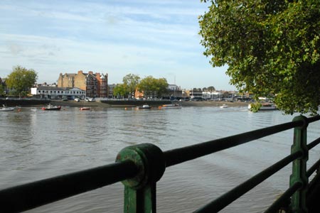
The River Thames is a focal point for London offering residents and tourists a wonderful resource for leisure and sightseeing. This easy walk explores the section of the River Thames between Putney Bridge and Barnes Bridge. Our route covers the first four miles of the distance covered by the annual Boat Race between Oxford and Cambridge Universities.
The start is Putney Bridge Underground station (grid ref. TQ245759) which is served by frequent District line trains. Exit the station and follow the signs opposite directly you to the Thames Path. We are heading upstream towards Hammersmith Bridge. So reaching the path alongside the Thames you should have the river on your left as you walk. You pass under Putney Bridge and almost immediately enter Fulham Palace Gardens with pleasant areas of grass and fine mature trees. This soon becomes Bishops Park with some very busy sports grounds at weekends.
On the river, certainly at weekends, you will be surprised by the amount of activity especially by rowing clubs with pair, fours and eights all practicing on the river. Also you see across the river rowing clubs with their concrete slipways. Reaching Craven Cottage, the home of Fulham Football Club, the path is forced away from the river bank as you follow the perimeter of the ground. You are soon back on the river though with the Wetlands Centre on the opposite bank.
You will also see evidence of wharves on the riverside - evidence that this was a busy working river in times gone by. Across the river you will also see Harrod's Depository, a rather grand building for humble storage. Ahead lies Hammersmith Bridge. Work commenced on this elegant bridge in 1825 and it was the first suspension bridge across the Thames. Originally a toll bridge it was extensively refurbished in 1973.
Reaching Hammersmith Bridge, go under the walkway and then climb the steps on your right to gain access to the bridge. Cross the bridge and once on the other side regain the riverside footpath and continue upstream. You soon pass the slipways for St Paul's School Rowing Club and then enter a stretch of riverbank that is quite rural. The amount of birdlife on this section was a surprise with many cormorants drying their outstretched wings. The next bridge soon comes into sight. This is Barnes Bridge which carries the railway across the Thames. Unlike the boat crews in the annual Boat Race, we terminate the walk here while they have another three-quarters of a mile to go as they head for Mortlake.
There are many opportunities for refreshments here. Barnes has a pleasant High Street and green giving it a village feel. Trains from Barnes Bridge railway station are every 15 minutes to Waterloo.
Other walks nearby
| Walk 3054 | Barnes to Richmond along the Thames Path | easy | 6.0 miles |
| Walk 3069 | Queensway to Buckingham Palace | easy | 3.5 miles |
| Walk 1322 | Green Park to Trafalgar Square | easy | 2.5 miles |
| Walk 2360 | Green Park to Westminster via Sloane Square | easy/mod | 5.5 miles |
| Walk 3012 | Green Park to Trafalgar Square via Lambeth Bridge | easy | 4.5 miles |
| Walk 3698 | Central London from Green Park | easy | 5.2 miles |
| Walk 3448 | Richmond Park and Petersham Circular | easy/mod | 8.9 miles |
| Walk 1570 | Westminster to Green Park via St. Paul's | easy/mod | 5.5 miles |
| Walk 3013 | Trafalgar Square circular | easy | 3.0 miles |
| Walk 3379 | Euston to the Monument via St. Paul's | easy | 4.0 miles |
Recommended Books & eBooks
The Thames Path Map Booklet
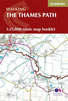 Map of the 180 mile (288km) Thames Path National Trail, from London's Thames Barrier to the river's source near Cirencester in Gloucestershire. This booklet is included with the Cicerone guidebook to the trail, and shows the full route on OS 1:25,000 maps. The easy riverside route takes around two weeks to walk.
More information
Walking in London
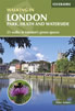 A guidebook to 25 walks in London's green spaces and nature reserves, covering both the city centre and Greater London area. Taking in woods and forests, parks and heaths, canals and rivers, the guide includes a wealth of information about some of the species you might encounter as well as the history and conservation of these areas.
More information
Messaging & Social Media
Message Walking Britain and follow the latest news.

Mountain Weather
Stay safe on the mountains with detailed weather forecasts - for iOS devices or for Android devices.