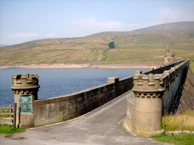
Scar House & Angram Reservoirs
Nidderdale AONB Walk
Region - Nidderdale AONB
County/Area - North Yorkshire - Nidderdale AONB
Author - Yorkshire Water
Length - 4.0 miles / 6.5 km Ascent - 250 feet / 76 metres
Time - 2 hours 20 minutes Grade - easy
Maps 

| Ordnance Survey Explorer OL30 | Sheet Map | 1:25k | BUY |
| Anquet OS Explorer OL30 | Digital Map | 1:25k | BUY |
| Ordnance Survey Landranger 98 | Sheet Map | 1:50k | BUY |
| Anquet OS Landranger 98 | Digital Map | 1:50k | BUY |
Walk Route Description
Click image to see photo description.
Scar House and Angram Reservoirs are situated in wild moorland at the head of Nidderdale and lie only a few miles outside the boundaries of the Yorkshire Dales National Park. The basic route includes a full circuit of Scar House Reservoir and this can be extended by taking the less frequented path that hugs the shores of Angram Reservoir. This extended route adds about 2 miles to the walk.
This is one of the free reservoir walks produced by Yorkshire Water who are one of the county's largest landowners, with around 72,000 acres of land spanning National Parks, Areas of Outstanding Natural Beauty, the North York Moors and the Yorkshire Wolds. There is a wide range of walks on offer from gentle strolls around one of their picturesque reservoirs to more adventurous routes. Yorkshire Water have selected some of their top walks for you and split them into three regional packs. Just print them out and off you go.
Each site has its own walk pack that you can easily print out and take along with you. Each pack includes directions to the site, a summary of the walk, a list of facilities available, a detailed route map and route instructions. To download walk descriptions go to Yorkshire Water Walks.
Other walks nearby
| Walk 3659 | Scar House Reservoir, Dale Edge & Middlesmoor | moderate | 9.0 miles |
| Walk 2572 | West Scrafton & Middlesmoor from Lofthouse | mod/hard | 18.0 miles |
| Walk 1250 | Great Whernside | moderate | 8.0 miles |
| Walk 1277 | Starbotton & Kettlewell circular | easy/mod | 5.0 miles |
| Walk 1294 | Arncliffe & Kettlewell Circular | moderate | 7.0 miles |
| Walk 1632 | Arncliffe & Starbotton from Kettlewell | moderate | 7.0 miles |
| Walk 3333 | Redmire Force & the Templar's Chapel from West Witton | easy/mod | 6.7 miles |
| Walk 2406 | Ripon Rowel Walk Leg 4 - Ilton to Grewelthorpe | moderate | 10.5 miles |
| Walk 1254 | Yockenthwaite & Hubberholme | moderate | 8.0 miles |
| Walk 1281 | Buckden Pike | moderate | 10.5 miles |
Recommended Books & eBooks
Trail and Fell Running in the Yorkshire Dales
 Guidebook to 40 of the best trail and fell runs in the Yorkshire Dales National Park. Ranging from 5 to 24 miles, the graded runs start from bases such as Ribblehead, Dent, Sedbergh, Malham and Grassington and take in the region's diverse delights, from castles and waterfalls to iconic mountains such as Whernside, Ingleborough and Pen Y Ghent.
More information
Messaging & Social Media
Message Walking Britain and follow the latest news.

Mountain Weather
Stay safe on the mountains with detailed weather forecasts - for iOS devices or for Android devices.