High Cup Nick & Cow Green Reservoir
North Pennines Walk
Region - North Pennines
County/Area - Durham & Cumbria - PW North Pennines
Author - Lou Johnson
Length - 12.8 miles / 20.8 km Ascent - 600 feet / 182 metres
Time - 7 hours 0 minutes Grade - moderate
Maps 

| Ordnance Survey Explorer OL19 | Sheet Map | 1:25k | BUY |
| Anquet OS Explorer OL19 | Digital Map | 1:25k | BUY |
| Ordnance Survey Explorer OL31 | Sheet Map | 1:25k | BUY |
| Anquet OS Explorer OL31 | Digital Map | 1:25k | BUY |
| Ordnance Survey Landranger 91 | Sheet Map | 1:50k | BUY |
| Anquet OS Landranger 91 | Digital Map | 1:50k | BUY |
Walk Route Description
Click image to see photo description.
The North Pennines offer some wonderful walking through often wild and windswept landscapes. This walk uses a lengthy section of the Pennine Way which makes route finding much easier yet it still retains the natural characteristics of the area. The route is, in effect, an out and back walk something I'm not usually in favour of but in this case I feel the choice is justified. The walk is not demanding with little ascent yet the length and remoteness does mean you should be well prepared and carry food and drink. If you have the benefit of two cars then the walk could be extended to the village of Dufton making it a one-way walk.
The start is the small car park above Cow Green Reservoir (grid ref. NY810309) where you immediately get a feeling of the wild country you are about to traverse. From the car park walk back up the road and take the first path on the right (grid ref. NY812307) heading roughly south east. Reaching a cross track, turn left and continue to a tarmac track. Turn right and follow this access road to the dam to join the Pennine Way. Drop down to cross the river bridge, keeping left at the junction just over the river and continue to Birkdale (grid ref. NY804278).
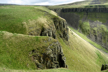
At grid ref. NY768267 you reach a bridge over Maize Beck. The westbound Pennine Way offers a choice of route from here, with a path on both the northern and southern sides of the Beck. For the purposes of this walk cross the Beck and follow the southern route of the Pennine Way. This will lead you without any further navigational problems to High Cup Nick. When approaching from this direction High Cup Nick is seen unfolding in a dramatic fashion and it is not until you have reached the crags at the edge of the glacial valley that you can fully appreciate this natural wonder.
Until this point you are unlikely to have seen many walkers but the "Nick" is a popular destination from the village of Dufton so you are unlikely to be able to enjoy the scenery in solitude. The return route follows the outward route. However a visit to Cauldron Snout close to the dame across the outlet to Cow Green Reservoir should not be missed. After crossing the bridge below the dam, turn right and follow the Pennine Way for a short distance. The wonderful waterfall of Cauldron Snout will soon be reached. After enjoying the spectacle, retrace your steps back to the dam, bear right along the access track and you will soon be back at the start.
Other walks nearby
| Walk 3424 | Cronkley Fell from Hanging Shaw | easy/mod | 7.0 miles |
| Walk 3526 | Hanging Shaw, Cronkley Scar, Low Force & High Force | moderate | 12.7 miles |
| Walk 1659 | Race Head & Sedling Rake from Wearhead | easy/mod | 6.0 miles |
| Walk 3099 | High Force, Low Force and the River Tees | easy/mod | 7.5 miles |
| Walk 3758 | Tynehead and Ashgill Force from near Garrigill | easy/mod | 8.2 miles |
| Walk 2393 | Weardale Circular from Westgate | easy/mod | 6.4 miles |
| Walk 1084 | Garrigill, Alston & Nenthead | moderate | 13.1 miles |
| Walk 1339 | High Cup Nick | moderate | 10.5 miles |
| Walk 3011 | Dufton Pike | easy/mod | 5.5 miles |
| Walk 3070 | Knock Fell & High Cup Nick | mod/hard | 12.0 miles |
Recommended Books & eBooks
Great Mountain Days in the Pennines
 An inspirational guidebook to 50 classic walks on the rolling Pennine landscape. The graded routes, between 6 and 13 miles in length, cover classic Pennine fells and moorland such as Whernside, Ilkley Moor and Pendle Hill; exploring the North and South Pennines, Yorkshire Dales, Howgills and Dark Peak. Many routes are also suited to fell running.
More information
The Pennine Way
 Guidebook to the Pennine Way National Trail with OS map booklet. The 265 mile route from Edale to Kirk Yetholm takes three weeks to walk and is suitable for fit and experienced long distance walkers. The route crosses the Peak District, Yorkshire Dales and North Pennines National Parks. Includes separate OS 1:25,000 map booklet of the route.
More information
Messaging & Social Media
Message Walking Britain and follow the latest news.

Mountain Weather
Stay safe on the mountains with detailed weather forecasts - for iOS devices or for Android devices.