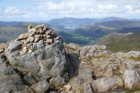
Great End & Glaramara from Seathwaite
Lake District Walk
Nat Park - Lake District - Lake District Southern Fells
Wainwrights - Allen Crags, Glaramara, Great End
County/Area - Cumbria
Author - Lou Johnson
Length - 7.7 miles / 12.5 km Ascent - 3000 feet / 909 metres
Time - 6 hours 50 minutes Grade - mod/hard
Maps 

| Ordnance Survey Explorer OL4 | Sheet Map | 1:25k | BUY |
| Anquet OS Explorer OL4 | Digital Map | 1:25k | BUY |
| Ordnance Survey Landranger 90 | Sheet Map | 1:50k | BUY |
| Anquet OS Landranger 90 | Digital Map | 1:50k | BUY |
Walk Route Description
Click image to see photo description.
This Lake District walk is full of interesting features and includes some wonderful views along the way. The route leaves Seathwaite and continues via Taylorgill Force to Styhead. From here the walk continues along the Corridor Route and then traverses rough ground without a path to the col between Broad Crag and Great End. From here the route follows clear paths although care with route finding for the final descent from Glaramara is required.
The start is Seathwaite (grid ref. NY235121) where parking can be at a premium at busy times of the year. After parking walk south to the Farm and follow the path through the arch to your right. Cross Grains Gill and immediately turn left through a gate. Follow this path, which is rather rough in places, up to Taylorgill Force where some simple scrambling adds some adventure to the route. Once level with the top of the waterfall continue up the valley towards Styhead Tarn keeping Styhead Gill on your left.
From Styhead Tarn continue ahead to the col. Walk east for about 200 metres and then locate the cairned path heading south. This is the Corridor Route and after a short descent the path starts to climb with the crags of Great End on your left as you enter a vast bowl set between the mountains. The path descends again and you soon reach Greta Gill (grid ref. NY217081). Leave the corridor route and follow Greta Gill upstream initially in a south-easterly direction. At first the un-pathed route climbs steeply beneath the crags of Round How to reach a level boggy area. From here the route continues to ascend over grassy slopes and scree to an obvious col between Broad Crag and Great End.
Reaching the main path, turn left and continue to the summit of Great End. Having enjoyed the view, descend southeast to Esk Hause. Drop down to the wind-shelter and then start the walk towards Glaramara. The first summit is Allen Crags followed by an undulating section passing Lincomb Tarns. Eventually you will reach Glaramara with its two summits. The northerly top is the highest and offers a grand panorama north to Borrowdale and beyond.
To start the descent head NNW for just over 250 metres. This initial section has some awkward rocky sections and you need to locate a cairned path heading northwest. Initially the path meanders across grassy slopes before starting a steep descent into the valley. Generally the path parallels Hind Gill although you only get occasional glimpse of the rocky chasm. Reaching easier ground continue through a gate, descend across a grassy slope, ford the beck and join the track back to Seathwaite for some well earned refreshment.
Other walks nearby
| Walk 1065 | Haystacks | moderate | 5.5 miles |
| Walk 1112 | Great Gable | hard | 7.3 miles |
| Walk 1245 | Castle Crag & Grange | easy/mod | 6.0 miles |
| Walk 1175 | Combe Gill Circuit | moderate | 5.5 miles |
| Walk 3328 | Eagle Crag & Seargeant's Crag from Stonethwaite | moderate | 7.0 miles |
| Walk 3133 | Ullscarf and Watendlath from Stonethwaite | mod/hard | 10.0 miles |
| Walk 1693 | Grange & Watendlath from Rosthwaite | easy/mod | 7.6 miles |
| Walk 1444 | Great Gable (Borrowdale route) | hard | 12.0 miles |
| Walk 1153 | The High Stile Ridge | hard | 10.0 miles |
| Walk 1289 | Fleetwith Pike & Haystacks | moderate | 5.5 miles |
Recommended Books & eBooks
Walking the Lake District Fells - Buttermere
 Part of the Walking the Lake District Fells series, this guidebook covers a wide range of routes to 32 Lakeland summits that can be climbed from the Buttermere, Lorton and Newlands valleys, with highlights including Haystacks, High Stile, Grasmoor and the fells of the Coledale Round. Suggestions for longer ridge routes are also included.
More information
Walking the Lake District Fells - Mardale and the Far East
 Part of the Walking the Lake District Fells series, this guidebook covers a wide range of routes to 36 Lakeland summits that can be climbed from the Ullswater, Haweswater, Troutbeck, Kentmere and Longsleddale valleys, with highlights including High Street, Place Fell and the Kentmere fells. Suggestions for longer ridge routes are also included.
More information
Messaging & Social Media
Message Walking Britain and follow the latest news.

Mountain Weather
Stay safe on the mountains with detailed weather forecasts - for iOS devices or for Android devices.