Holme & Marsden Clough from Ramsden Reservoir
South Pennines Walk
Nat Park - Peak District - Black Hill Dovestone
Region - South Pennines
County/Area - West Yorkshire
Author - Andy Chaplin
Length - 9.0 miles / 14.6 km Ascent - 1450 feet / 439 metres
Time - 6 hours 0 minutes Grade - moderate
Maps 

| Ordnance Survey Explorer OL1 | Sheet Map | 1:25k | BUY |
| Anquet OS Explorer OL1 | Digital Map | 1:25k | BUY |
| Ordnance Survey Landranger 110 | Sheet Map | 1:50k | BUY |
| Anquet OS Landranger 110 | Digital Map | 1:50k | BUY |
Walk Route Description
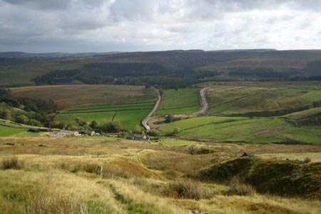
Click image to visit gallery of 3 images.
Several walks around Holme Moss seem to rely upon a portion of cross country walking at some point - normally east of Holme Moss. This Peak District walk sticks to well defined paths and although at times the outward and return routes are quite close, there is never a sense of doing a 'there and back'.
The Yorkshire Water car park (grid ref. SE115057) next to Ramsden Reservoir has parking for a dozen cars as well as a limited amount of on-road parking. Go south along the road and continue on the track over the Riding Wood Reservoir dam wall. The track, now Kiln Bent Road continues all the way around the bottom of Yateholme Reservoir before becoming Holme Woods Road and Rake Head Road when it comes out on the A6024 at Ings Bridge. On the way you see Ramsden and Riding Wood Reservoirs - but see nothing of Yateholme but the wall.
Walk a little way north on the road then go off left on a lane in front of a house and climb up the hill on a footpath that leads up to a ruined farmhouse or sheep pen. Go due north on a path that goes either side of a ditch/wall until you reach a gate that leads onto the Cliff Road track. As this track descends towards the Issues Road track there are good views down towards Holme.
Turn left up the Issues Road and keep heading in the general direction of Black Hill. At grid ref. SE088058 follow the path to the right - not ascending up to the Pennine Way - and continue on to the bridge over the Marsden Clough. This is a very pleasant place to stop for a while before climbing up to the Kirklees Way on the other side of the Clough.
Turn right and follow the Kirklees Way down Nether Lane and Hoowood Lane to the Digley Reservoir. Keep following the KW over Meal Hill into Holme. From here you can either continue straight back to the parking on the KW or take the long way home.
The longer route involves going right on the A6024 then taking the path off left over the Rake Dike at Gill Hey Bridge and looping around to the top of Ramsden Reservoir before coming back north under Netherley Brow on a permissive path that joins the KW before it crosses the dam wall and goes back to the parking.
Either way you will get great views of the reservoir as you cross over the dam wall.
Other walks nearby
| Walk 2630 | Upper Holme Valley & Ramsden Clough | moderate | 9.0 miles |
| Walk 1583 | Digley Reservoir | easy/mod | 5.0 miles |
| Walk 2561 | Digley & Ramsden Reservoirs from Wessenden Head | moderate | 9.5 miles |
| Walk 2518 | Black Hill & Four Reservoirs from near Wessenden Head | moderate | 10.0 miles |
| Walk 2719 | Huddersfield's green fringe | easy/mod | 10.0 miles |
| Walk 2826 | Winscar Reservoir circuit from Dunford Bridge | moderate | 8.9 miles |
| Walk 3174 | Saltersbrook and Lady Cross from Woodhead | easy/mod | 6.0 miles |
| Walk 1756 | Bleaklow & The Longendale Trail from Woodhead | mod/hard | 10.0 miles |
| Walk 1586 | Blackmoorfoot Reservoir | easy | 1.5 miles |
| Walk 1179 | Lad's Leap & Laddow Rocks from Crowden | moderate | 6.5 miles |
Recommended Books & eBooks
Great Mountain Days in the Pennines
 An inspirational guidebook to 50 classic walks on the rolling Pennine landscape. The graded routes, between 6 and 13 miles in length, cover classic Pennine fells and moorland such as Whernside, Ilkley Moor and Pendle Hill; exploring the North and South Pennines, Yorkshire Dales, Howgills and Dark Peak. Many routes are also suited to fell running.
More information
Walking in the Peak District - White Peak East
 Guidebook describing 42 half-day and day walks in the limestone landscapes of Derbyshire's White Peak, part of the Peak District National Park. One of two volumes, this book covers the east of the region, with potential bases including Bakewell, Eyam, Castleton, Birchover, Matlock and Wirksworth.
More information
Messaging & Social Media
Message Walking Britain and follow the latest news.

Mountain Weather
Stay safe on the mountains with detailed weather forecasts - for iOS devices or for Android devices.