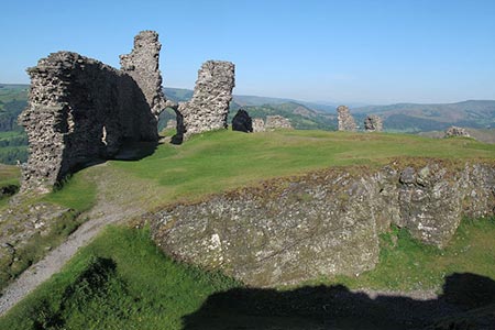
Castell Dinas Bran from Llangollen
Denbighshire Walk
County/Area - Denbighshire
Author - Lou Johnson
Length - 4.0 miles / 6.5 km Ascent - 900 feet / 273 metres
Time - 2 hours 50 minutes Grade - easy/mod
Maps 

| Ordnance Survey Explorer 256 | Sheet Map | 1:25k | BUY |
| Anquet OS Explorer 256 | Digital Map | 1:25k | BUY |
Walk Route Description
Click image to see photo description.
This Denbighshire walk explores the ruins of the 13th century Castell Dinas Bran perched on an outcrop high above the town. The walk starts from the bridge over the River Dee in the centre of the town (grid ref. SJ215421). A variety of options for parking are available within the town with several pay and display parking areas signed from the main roads. After parking locate the bridge.
From the bridge, aptly called the Llangollen Bridge, walk north (with Llangollen railway station to your left). At the T-junction cross the road using the pedestrian crossing and turn right along the A539 towards Ruabon. Almost immediately turn left into Wharf Hill. After a short distance take the tarmac path on the right angling up to the Llangollen Canal towing path. Follow this tarmac path east (with the canal on your left) for just over a mile. To reach the first overbridge at Llanddyn Cottage (grid ref. SJ231425). Bear right off the canal towpath, turn left up the lane and cross the canal.
Stay on the lane, which climbs steadily, passing Llandyn Hall on your right to reach the entrance to Llandyn Hall Farm (grid ref. SJ228427), turn left and follow the path across fields. Bear left after a short distance and continue past Wern-uchaf to reach a lane (grid ref. SJ224426). Turn right up the lane climbing steadily. After half a mile of walking on the lane, turn left at the fingerpost pointing to Castell Dinas Bran (grid ref. SJ226432). The path climbs steeply soon reaching the ruins of this 13th century castle from where some superb views over Llangollen and the surrounding hills and valleys can be enjoyed.
Descend to the left to join a track enclosed with fences. This leads you a crossroads (grid ref. SJ216428). Go straight across and continue the descent down a narrow lane to reach Wern Road (grid ref. SJ215422). Go straight ahead crossing the Llangollen Canal following Wharf Hill back towards the Llangollen Bridge.
Other walks nearby
| Walk 1067 | Ruabon Mountain & The Limestone Edges of Llangollen | moderate | 11.0 miles |
| Walk 3655 | Rhewl, Moel y Gamelin & Moel Morfydd | moderate | 5.4 miles |
| Walk 2598 | Ruabon Mountain, World's End & Panorama Circular | moderate | 12.5 miles |
| Walk 2460 | Pontcysyllte Aqueduct Circular | easy | 4.5 miles |
| Walk 2388 | Chirk Castle & Ceiriog Valley | easy/mod | 6.0 miles |
| Walk 1989 | Llanarmon Dyffryn Ceiriog Circular | moderate | 6.0 miles |
| Walk 3031 | Cadair Berwyn | moderate | 9.3 miles |
| Walk 1256 | Cadair Bronwen | moderate | 9.5 miles |
| Walk 1086 | Post Gwyn and Craig-y-Mwn from Pistyll Rhaeadr | moderate | 6.5 miles |
| Walk 3053 | Berwyn Tops from Tan Y Pystyll | moderate | 14.0 miles |
Recommended Books & eBooks
No suggestions for this area.Messaging & Social Media
Message Walking Britain and follow the latest news.

Mountain Weather
Stay safe on the mountains with detailed weather forecasts - for iOS devices or for Android devices.