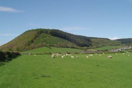
Stowe & Offa's Dyke from Kinsley Wood
Shropshire Hills Walk
Region - Shropshire Hills
County/Area - Shropshire
Author - Peter Lane
Length - 7.0 miles / 11.4 km Ascent - 1300 feet / 394 metres
Time - 4 hours 50 minutes Grade - moderate
Maps 

| Ordnance Survey Explorer 201 | Sheet Map | 1:25k | BUY |
| Anquet OS Explorer 201 | Digital Map | 1:25k | BUY |
| Ordnance Survey Landranger 137 | Sheet Map | 1:50k | BUY |
| Anquet OS Landranger 137 | Digital Map | 1:50k | BUY |
Walk Route Description
Click image to visit gallery of 10 images.
A pleasant walk in the Marches near the Welsh border that explores rolling green hills and a section of Offa's Dyke without touching civilisation. Never truly flat, this walk requires some stamina, however, a longer 12 mile version is possible which requires more energy and explores more of the Dyke and the surrounding scenery (see walk 2816).
Start at the Forestry Commission Kinsley Wood Car Park just off the A488 at grid reference SO298728. This car park can only be approached from the Knighton direction as it has a sharply graded access road (not signposted). Park at the first turn on the Forestry Commission track next to the public footpath that forms the start point. Picnic tables and an information board can be found at the northern extremity of the wood, but we shall forego these for now.
Descend the wooden steps at the signed footpath at the first bend in the access road as described above. Enter a field and cross a footbridge part way through the field. Exit the field at the stile, cross the A488 and pick up the bridlepath heading for Stowe. This initially follows the right hand fence and later crosses to the left. Pass through a number of gates until the crest of the hill is reached. With Stowe church in the valley below, descend a couple of hundred metres or so to a bridlepath signed on the left and drop down to the valley below, crossing the stream. Climb the steep hill next to the house and an old farm building adjacent to the wood. Enter the wood where signed about half way up the hill and follow the winding path until it emerges onto a broad track at a metal gate.
Pass through the gate and climb the broad track past a circular pool and then up through surrounding cols to Holloway Rocks. When the track opens out onto a meadow plateau, resist the temptation to continue following it into the wood on the right, but head virtually due north to the field boundary and the ruts of the "byway open to all traffic" (fat chance in a family saloon!). Don't cross the fence but turn left and follow this obvious track west all the way to Five Turnings on the A488.
Cross the main road and take the bridlepath opposite through the metal gate adjacent to the driveway of New House. When this bridlepath opens out into a field, a marker post shows the split of the path into two. The convenient right hand path is closed, so there is no choice but to take the left hand path up the hill towards a sparse wood on the summit. Over the summit the path opens up to a broad track. Continue down this track as it descends and crosses the Offa's Dyke National Trail
Turn left here and continue roughly south on the well marked National Trail along an obvious section of Offa’s Dyke. Keeping the boundary to the left at all times, the path follows the ridge until the picturesque border town of Knighton appears in the valley below. The path now descends to a wood. When the National Trail turns off steeply to the right towards Knighton, continue for about 100 metres to a stile on the left. Cross the stile and follow the boundary of Kinsley Wood, reaching a metal gate and the car park and information board. Head for the information board and take the footpath along the summit of the wood here, keeping left at every junction until a small footpath is reached that descends sharply back to the main access road. Turn right upon reaching this and return to the car park directly.
Other walks nearby
| Walk 3631 | Panpunton Hill & Stowe from Knighton | moderate | 7.8 miles |
| Walk 3643 | LLan-fawr & Lugg Valley from Whitton | moderate | 7.5 miles |
| Walk 3050 | Clun circular | moderate | 11.5 miles |
| Walk 1998 | Harley's Mountain from Lingen | easy/mod | 7.5 miles |
| Walk 1785 | Newcastle on Clun circular | moderate | 7.5 miles |
| Walk 1673 | Shobdon Hill and Croft Ambrey from Shobdon Estate | moderate | 12.5 miles |
| Walk 3023 | Great Rhos & the Radnor Forest from New Radnor | moderate | 9.0 miles |
| Walk 3614 | Herrock Hill from Kington | moderate | 8.0 miles |
| Walk 1203 | Stokesay Castle & View Edge | moderate | 8.0 miles |
| Walk 3285 | The Hergest Ridge and Huntington from Kington | moderate | 12.0 miles |
Recommended Books & eBooks
Hillwalking in Shropshire
 Guidebook to 32 walking routes in Shropshire in the West Midlands. The routes range from 3 miles (5km) to 12 miles (19km), taking in highlights such as The Wrekin, Wenlock Edge, Long Mynd and Stiperstones, Castle Ring and Bury Ditches. Many routes start near delightful towns and villages including Church Stretton, Ludlow and Bishops Castle.
More information
Messaging & Social Media
Message Walking Britain and follow the latest news.

Mountain Weather
Stay safe on the mountains with detailed weather forecasts - for iOS devices or for Android devices.