Harrison Stickle, Pike o'Stickle & Rosset Pike
Lake District Walk
Nat Park - Lake District - Lake District Central Fells
Wainwrights - Harrison Stickle, Pike O'Stickle, Rossett Pike
County/Area - Cumbria
Author - Peter Smyly
Length - 8.3 miles / 13.4 km Ascent - 2800 feet / 848 metres
Time - 7 hours 0 minutes Grade - moderate
Maps 

| Ordnance Survey Explorer OL6 | Sheet Map | 1:25k | BUY |
| Anquet OS Explorer OL6 | Digital Map | 1:25k | BUY |
| Ordnance Survey Landranger 90 | Sheet Map | 1:50k | BUY |
| Anquet OS Landranger 90 | Digital Map | 1:50k | BUY |
Walk Route Description
Click image to visit gallery of 10 images.
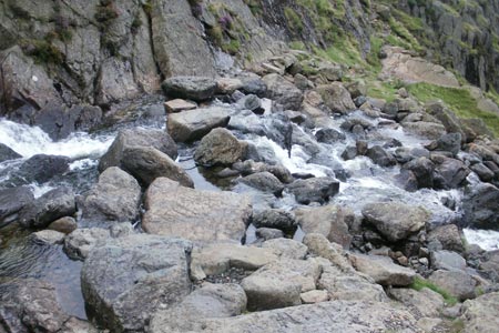
This excellent Lake District walk starts from the car park at the New Dungeon Ghyll Hotel, a well-constructed stone path leads the way upwards, passing the beck on the right and with Pavey Ark showing ahead on the right with Harrison Stickle on the left. For the most part, the route up to Stickle Tarn is obvious but there is one point where a choice will have to be made concerning the ongoing route. A few minutes from the tarn, the path crosses Stickle Beck from right to left. The choice is either to pick your way across rocks, a straightforward enough task for most, or to clamber up steeply to the right and follow the way up to the tarn from there.
Either way, Pavey Ark dominates the view ahead and the rushing waters of the stream beyond the dam announce that Stickle Tarn is about to appear. The tarn is a good place to stop for a while and admire the cliffs of Pavey Ark and the diagonal traverse of Jack's Rake.
From the dam, a path goes to the left and then right as it heads up Harrison Stickle. Looking across to Pavey Ark, you may be able to spot some walkers scrambling up Jack's Rake. The top of Harrison Stickle commands fine views in different directions including a look down the Great Langdale valley way below.
The next summit, the dome-shaped Pike of Stickle is clearly in view to the west and the descent is quite steep off Harrison Stickle before the ground levels out and then a gentle path leads towards the next objective. Look out for a scree slope to the left that goes all the way down to the Mickleden valley below, though it is not recommended as a descent route. The climb up to the top of Pike of Stickle involves some basic scrambling in places and the last time I was there, someone had left an upturned spade in the summit cairn (see photo). "A view to die for" was how one fellow walker in another group described the summit view on this occasion.
Rossett Pike, the third summit on the walk, appears dwarfed by Great End from Pike of Stickle. Next, head due north west and the path is intermittent in places but the right direction clear as you pass Martcrag Moor and the Stake Pass. The latter offers a way of cutting the walk shorter by omitting the third summit and taking a more direct route to the descent down part of the Cumbria Way to Mickleden. Down into the dip the path goes and then relatively steeply up the other side. The top of Rossett Pike is a rocky one and it offers a fine view of nearby Bowfell in particular.
Descending to the col between Rossett Pike and Hanging Knotts, a glimpse of Angle Tarn can be seen. The path down Rossett Ghyll towards Mickleden is generally steep and rocky and calls for careful footwork. Eventually, the gradient eases off and then begins the long walk back down Mickleden. I have heard some people say that Mickleden seems to go on forever and it can feel like that. The path passes Middle Fell Farm leading to a tarmac road and then it is simply a question of following the road back down the valley to rejoin the car park at the start point of the walk.
Other walks nearby
| Walk 1132 | Great Langdale & The Crinkle Crags | mod/hard | 7.0 miles |
| Walk 1157 | Bowfell and Esk Pike | hard | 8.8 miles |
| Walk 2037 | Bowfell & Rosset Pike via the Climber's Traverse | hard | 7.5 miles |
| Walk 2818 | Bowfell Circular from Great Langdale | mod/hard | 7.0 miles |
| Walk 1739 | Crinkle Crags and Bowfell (Oxendale Horseshoe) | hard | 7.8 miles |
| Walk 1144 | Lingmoor Fell | moderate | 8.0 miles |
| Walk 1171 | Pike o' Blisco | moderate | 5.0 miles |
| Walk 2582 | Pike o' Stickle, Harrison Stickle & Pavey Ark | moderate | 6.0 miles |
| Walk 1141 | Elterwater circular | easy/mod | 4.0 miles |
| Walk 1059 | Colwith Force and Skelwith Force | easy/mod | 4.8 miles |
Recommended Books & eBooks
Walking the Lake District Fells - Wasdale
 Part of the Walking the Lake District Fells series, this guidebook covers a wide range of routes to 25 Lakeland summits that can be climbed from the Wasdale, Eskdale and Ennerdale valleys, with highlights including Scafell Pike, Great Gable and Pillar. Suggestions for longer ridge routes are also included.
More information
Great Mountain Days in the Lake District
 An inspirational guidebook to 50 challenging walks on the high fells of the Lake District. The graded circular routes, between 4 and 14 miles in length, cover classic Lakeland summits like Fairfield, Scafell Pike, Great Gable and Blencathra, to the lesser-known High Spy, King's How and Brund Fell.
More information
Messaging & Social Media
Message Walking Britain and follow the latest news.

Mountain Weather
Stay safe on the mountains with detailed weather forecasts - for iOS devices or for Android devices.