Black Combe from near Stoneside Hill
Lake District Walk
Nat Park - Lake District - Lake District Lesser Fells
County/Area - Cumbria
Author - Lou Johnson
Length - 6.3 miles / 10.2 km Ascent - 1350 feet / 409 metres
Time - 4 hours 30 minutes Grade - easy/mod
Maps 

| Ordnance Survey Explorer OL6 | Sheet Map | 1:25k | BUY |
| Anquet OS Explorer OL6 | Digital Map | 1:25k | BUY |
Walk Route Description
Click image to see photo description.
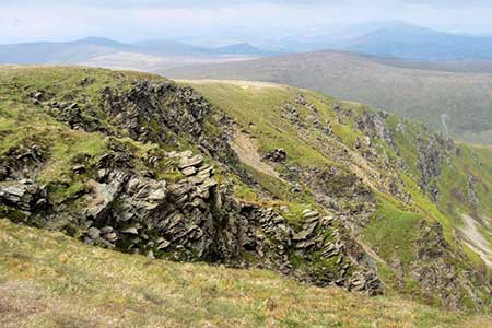
Walk to the summit of Black Combe which lies in the south-western corner of the Lake District National Park within a few miles of the Irish Sea. Rising to 600 metres (1970 feet) the western slopes are rounded and smooth whilst the to the east a series of crags provide scenic interest. The route detailed below uses an approach from the north, which involves less ascent than other routes.
The start is a small off-road parking area (grid ref.SD150896) near the summit of the fell road from Waberthwaite. After parking walk south following a path with a fence on your right to the rocky summit of Stoneside Hill. From here the smooth rounded shape of Black Combe is in view to the south. Descend the other side towards a group of trees and a sheep fold. Cross the fence down in a shallow valley. You will need to pick your route carefully to avoid wet feet.
Head up the easy slope ahead keeping a fence on your left to reach a fence on the almost flat top of Stoupdale Head. Cross the fence and descend slightly to walk along the edge of Whitecombe Screes on your left. Continue along the top of Anna Crag soon arriving at Blackcombe Screes with a deep bowl cut into the hillside. A final steady ascent leads to the summit of Black Combe with its OS trig column. The view from the summit is not the best and it is recommended that you head south to the subsidiary summit (587 m.) from the where the view is much improved.
To return to the start follow the outward route. A short diversion to the right from Stoupdale Head offers an excellent view down Stoupdale. Return to the fence and continue the walk downhill and back to the start.
Other walks nearby
| Walk 2281 | White Combe FROM near Whicham | easy/mod | 4.5 miles |
| Walk 1301 | Great Stickle & Stickle Pike | moderate | 5.0 miles |
| Walk 1993 | Ravenglass & the Esk Estuary | easy | 3.4 miles |
| Walk 1668 | Silver Knott & Muncaster Fell from Irton Road | easy/mod | 5.0 miles |
| Walk 3656 | Hodbarrow Lagoon from Haverigg | easy | 4.2 miles |
| Walk 2355 | Blea Tarn & Eskdale Green | easy/mod | 6.5 miles |
| Walk 1299 | Green Crag | moderate | 6.5 miles |
| Walk 2361 | Scafell & Slight Side | hard | 9.5 miles |
| Walk 2362 | Scafell Pike and Scafell | very hard | 11.0 miles |
| Walk 2675 | Eel Tarn and Stony Tarn | easy/mod | 6.0 miles |
Recommended Books & eBooks
Walking the Lake District Fells - Patterdale
 Part of the Walking the Lake District Fells series, this guidebook covers a wide range of routes to 35 Lakeland summits that can be climbed from Ambleside, Grasmere and Patterdale and the Thirlmere and Ullswater valleys, with highlights including Helvellyn and Fairfield. Suggestions for longer ridge routes are also included.
More information
Walking the Lake District Fells - Keswick
 Part of the Walking the Lake District Fells series, this guidebook covers a wide range of routes to 30 Lakeland summits that can be climbed from Keswick, Whinlatter, Bassenthwaite, Caldbeck, Mungrisdale and Threlkeld, with highlights including Skiddaw and Blencathra. Includes suggestions for longer ridge routes.
More information
Messaging & Social Media
Message Walking Britain and follow the latest news.

Mountain Weather
Stay safe on the mountains with detailed weather forecasts - for iOS devices or for Android devices.