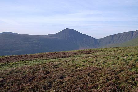
Pen y Fan from Cwmgwdi near Brecon
Brecon Beacons/Bannau Brycheiniog Walk
Nat Park - Brecon Beacons - Brecon Beacons Central
County/Area - Powys
Author - Rhydian Williams
Length - 5.0 miles / 8.1 km Ascent - 2000 feet / 606 metres
Time - 4 hours 30 minutes Grade - moderate
Maps 

| Ordnance Survey Explorer OL12 | Sheet Map | 1:25k | BUY |
| Anquet OS Explorer OL12 | Digital Map | 1:25k | BUY |
| Ordnance Survey Landranger 160 | Sheet Map | 1:50k | BUY |
| Anquet OS Landranger 160 | Digital Map | 1:50k | BUY |
Walk Route Description
Click image to visit gallery of 4 images.
The Brecon Beacons offer many opportunities for walking and this route onto the highest summit in the range makes a pleasant half day excursion into this National Park. The start is the car park (grid ref. SO024248), which can be found about half a mile south of Cwmgwdi, a small hamlet easily reached from Brecon.
After parking walk south from the car park taking the well defined path leading to Cefn Cwm Llwych. The path soon climbs steeply for half a mile before the gradient eases. Quite early in the walk you are rewarded with improving views over the Wye Valley to the north. Ahead you can see the main objective of this walk, Pan y Fan (886 m.) with its sister peaks of Corn Du (873 m.) and Cribyn (795 m.) to its right and left respectively.
Having gained the ridge of Cefn Cwm Llwych you lose a little height before making the final climb onto Pen y Fan. This section of the route is steep but it offers a spectacular view of the north facing cliffs of the Brecon Beacons something which cannot be appreciated when approaching from the south.
It is unlikely you will be alone on Pen Y Fan as it is a very accessible summit especially from the west. Having gained all this height it might be worthwhile extending the walk either turning west to visit Corn Du or east to Cribyn. However do remember that the latter summit entails a stiff climb back onto Pen y Fan.
To return to the start retrace your steps to the start. Caution is needed on the initial descent from Pen y Fan's summit especially after rain or in winter conditions. With the route downhill all the way back to the start you can enjoy the superb panorama ahead with the hills of mid-Wales rising above the Wye Valley.
Other walks nearby
| Walk 3210 | Pen-y-Crug hill fort from Brecon | easy | 3.0 miles |
| Walk 3564 | Groesfford and M & B Canal from Brecon | easy/mod | 6.2 miles |
| Walk 3236 | Pen-y-crug, Sarnau and Battle from Brecon | moderate | 10.0 miles |
| Walk 2648 | The Black Mountain, Brecon Beacons | moderate | 8.0 miles |
| Walk 2641 | Fan Fawr & Fan Frynych, Fforest Fawr | moderate | 6.5 miles |
| Walk 3209 | Llanfrynach and Pencelli circular | easy/mod | 5.6 miles |
| Walk 2349 | Pen Y Fan & Corn Du from near Storey Arms | moderate | 4.6 miles |
| Walk 3616 | Fan Fawr from Storey Arms | moderate | 6.0 miles |
| Walk 3546 | Pen y Bryn from Pencelli | moderate | 5.0 miles |
| Walk 3536 | Pen y Bryn & Carn Pica from Pencelli | mod/hard | 11.3 miles |
Recommended Books & eBooks
The Cambrian Way
 Guidebook to the Cambrian Way, a challenging three-week mountain trek through Wales from Cardiff to Conwy. The 470km un-waymarked route is presented from south to north. Often sticking to long, beautiful ridgelines, it crosses wild and rugged terrain and visits many of Wales's highest mountains, including Snowdon.
More information
Walking in Carmarthenshire
 Guidebook to 30 walking routes (2 to 10 miles) in Carmarthenshire, south Wales, including sections of Carmarthenshire Coast Path. Walks for all abilities, including coastal, river, forest and hill walks in Cambrian Mountains, Tywi Valley, Y Mynydd Du (Black Mountains) and Brecon Beacons. Easy access from Bristol, Cardiff and Swansea.
More information
Messaging & Social Media
Message Walking Britain and follow the latest news.

Mountain Weather
Stay safe on the mountains with detailed weather forecasts - for iOS devices or for Android devices.