Shipman Knotts & Kentmere Pike
Fell Walk + Hill Walk
Nat Park - Lake District - Lake District Far Eastern Fells
Wainwrights - Shipman Knotts, Kentmere Pike
County/Area - Cumbria
Author - Lou Johnson
Length - 6.2 miles / 10.1 km Ascent - 1800 feet / 545 metres
Time - 4 hours 50 minutes Grade - moderate
Maps 

| Ordnance Survey Explorer OL7 | Sheet Map | 1:25k | BUY |
| Anquet OS Explorer OL7 | Digital Map | 1:25k | BUY |
Walk Route Description
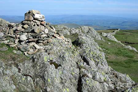
Click image to see photo description.
A straightforward ascent of Kentmere Pike that offers excellent walking with superb views. The outward route follows a path over Wray Crag to the summit of Shipman Knotts. The walk continues to reach the minor top above Goat Scar to gain the main ridge which is followed to Kentmere Pike's summit. The return route descends to Hallow Bank from where bridleways and lanes return to the start.
The walk starts from the small community of Green Quarter (grid ref. NY461041) where there is parking space for a few cars. If none are available, then start from Kentmere. From the small village green walk uphill along the no-through road and join the signed path which heads uphill northwest to join the Hallow Bank to Sadgill track (grid ref. NY476050) which lies in a broad col. Cross the track and follow the path steeply uphill with a wall on your right. This path leads over Wray Crag and continues up to the summit of Shipman Knotts.
After a very brief descent continue up to a ladder stile over a wall (grid ref. NY472067). Once over the stile you can either take the main path or my preferred choice is to follow the fence on your right up to the minor top (spot height 629m) and then turn left along the fence and later a wall to the summit of Kentmere Pike. The view is extensive and includes Yoke, Ill Bell etc. across the Kentmere valley. The view also extends east to Harrop Pike and Selside. Looking southwest Windermere can also be seen.
To start the descent, retrace your steps along the approach path. Just before the wall changes to a fence, fork left and follow a grassy path down to a ladder stile (grid ref. NY470069). The path soon swings southwest then heads down a grassy gulley to pass through a gap in a wall (grid ref. NY467061). Continue to descend to reach Hallow Bank. Head downhill along a narrow lane to reach a fingerpost on the right. Turn right down the signed bridleway and approaching houses ahead turn left. Pass a barn on your right and continue along the track as it turns south. You are now on Low Lane (track) which heads south with a wall on your right. After 300 metres the track runs between walls and after 600 metres reaches a tarmac lane. Turn right and continue back to Green Quarter.
Other walks nearby
| Walk 1320 | Shorter Kentmere Horseshoe | mod/hard | 10.5 miles |
| Walk 2652 | Photographer's Kentmere Horseshoe | mod/hard | 13.5 miles |
| Walk 1147 | Longsleddale and Kentmere Pike | moderate | 8.0 miles |
| Walk 3033 | Tarn Crag & Harrop Pike from Sadgill | moderate | 5.5 miles |
| Walk 1463 | School Knott & Grandsire from Ings | easy/mod | 6.5 miles |
| Walk 2464 | Kentmere Valley Circular | moderate | 10.0 miles |
| Walk 1049 | Staveley Tarns circular | easy/mod | 6.0 miles |
| Walk 1555 | Brunt Knott from Staveley | easy/mod | 7.0 miles |
| Walk 1109 | Harter Fell & Nan Bield Pass | moderate | 4.5 miles |
| Walk 1269 | High Street & Kidsty Pike | moderate | 7.5 miles |
Recommended Books & eBooks
Walking the Lake District Fells - Mardale and the Far East
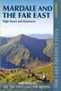 Part of the Walking the Lake District Fells series, this guidebook covers a wide range of routes to 36 Lakeland summits that can be climbed from the Ullswater, Haweswater, Troutbeck, Kentmere and Longsleddale valleys, with highlights including High Street, Place Fell and the Kentmere fells. Suggestions for longer ridge routes are also included.
More information
Great Mountain Days in the Lake District
 An inspirational guidebook to 50 challenging walks on the high fells of the Lake District. The graded circular routes, between 4 and 14 miles in length, cover classic Lakeland summits like Fairfield, Scafell Pike, Great Gable and Blencathra, to the lesser-known High Spy, King's How and Brund Fell.
More information
Messaging & Social Media
Message Walking Britain and follow the latest news.

Mountain Weather
Stay safe on the mountains with detailed weather forecasts - for iOS devices or for Android devices.