The Pots & Pans from Uppermill
Peak District Walk
Nat Park - Peak District - Black Hill Dovestone
County/Area - Greater Manchester
Author - Lou Johnson
Length - 4.5 miles / 7.3 km Ascent - 800 feet / 242 metres
Time - 3 hours 0 minutes Grade - easy/mod
Maps 

| Ordnance Survey Explorer OL1 | Sheet Map | 1:25k | BUY |
| Anquet OS Explorer OL1 | Digital Map | 1:25k | BUY |
| Ordnance Survey Landranger 110 | Sheet Map | 1:50k | BUY |
| Anquet OS Landranger 110 | Digital Map | 1:50k | BUY |
Walk Route Description
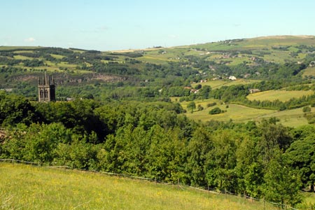
Click image to visit gallery of 12 images.
This Peak District walk leaves the urbanised valleys of Lancashire and takes you high on to the moors. The views are good stretching into the centre of Manchester and including the trip of reservoirs headed by Dove Stone Reservoir. Generally the route finding is easy for this type of walk although good sense of direction is needed for the descent back to valley. Conditions underfoot are generally good although do expect it to be soft places after heavy rain.
The start is on the road leading down to Saddleworth Church (grid ref. SE007063) where on street parking is available. This point is reached by following Church Road up from the main street in Uppermill. After parking, walk down to the church. Note the set of stocks in front of the church dated 1698. Bear right up the narrow lane from the corner of church and ignore the footpath. Continue up this lane to Ivy Bank Farm. Turn left just past the farm (grid ref. SE009064) on to the Oldham Way. This takes you across fields with care needed to pick up the route of the path. In the first section there is a new fence which can cause confusion over the onward route of the path.
The path descends to cross a couple of streams before reaching a tarmac lane (grid ref. SE010069). Turn right up the lane and continue straight ahead at the crossroads. Climbing relatively easily the views behind you are starting to improve. Eventually the lane reaches open country and becomes a track and then a path leading up Broadstone Clough with its small stream. Keep on the left hand side of the stream and reaching the top bear left on a clear path to the trig point on Broadstone Hill (454m), perhaps having a break to enjoy the view.
To continue, retrace your steps to the top of Broadstone Clough and follow the clear path ahead along the ridge. Pass the gritstone outcrops of Slades Rocks and Shaw Rocks. The path soon reaches a round boulder (The Sugar Loaf) from where you trend towards the eastern side of the ridge to enjoy views over Dove Stone, Yeoman Hey and Greenfield Reservoirs. Once on the eastern edge, turn south following a well-worn but narrow path towards Alderman's Hill. Located at the southern end of the ridge this is a fine viewpoint.
Turn back and make for the obelisk, which commemorates Saddleworth's losses in the two World Wars. This fine monument can be seen from the valley and offers a wide panorama west towards Manchester. Close to the obelisk is the 'Pots and Pans stone'. This has a number of natural circular cavities which some say look like cooking utensils, which can only be seen by clambering up on to the stone.
The onward route is a little sketchy and requires a reasonable sense of direction. Just to the north of the obelisk is a spot height 427m on the OS map. The suggested route is to find a narrow path on the western flank of this small hill and descend in a north-westerly direction towards Birches. The path eventually becomes much clearer as you descend. You reach a junction of paths where you turn north and contour across the side of Primrose Hill to the small group of cottages at Pob Green.
Turn left down the main access drive to this small settlement continuing downhill to reach a road. Turn left and at the next junction go right and you should be parked along this road.
Other walks nearby
| Walk 2634 | Broadstone Hill & the Cotton Famine Road | moderate | 7.0 miles |
| Walk 2600 | Chew Reservoir & the Pennine Way | mod/hard | 14.0 miles |
| Walk 2517 | Chew Reservoir & Fox Stone from Dovestones | moderate | 7.5 miles |
| Walk 2553 | Greenfield Reservoir & Raven Stones from Dovestone | moderate | 8.0 miles |
| Walk 2613 | Boundary Walk from Marsden | moderate | 13.0 miles |
| Walk 2359 | Cuckoo Walk & Bacon Butties from Marsden | hard | 19.5 miles |
| Walk 2644 | Marsden and the Standedge Trail | moderate | 11.0 miles |
| Walk 2926 | Cupwith & Shooter's Nab from Marsden | moderate | 13.0 miles |
| Walk 2946 | Buckstones and Linsgreave Head from Marsden | moderate | 8.8 miles |
| Walk 3159 | March Haigh Reservoir & Eastergate Bridge from Marsden | easy/mod | 5.0 miles |
Recommended Books & eBooks
Dark Peak Walks
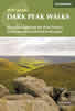 Guidebook to 40 walks in the Dark Peak area of the Peak District National Park. 35 circular routes for most abilities, from 8km to 19km, around Edale, Marsden, Fairholmes, Baslow and Castleton, including Kinder Scout and Mam Tor, and 5 longer (25km to 45km) routes highlighting the best of the Gritstone Edges, High Moorland and Deep Valleys.
More information
Walking in the Peak District - White Peak East
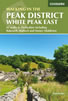 Guidebook describing 42 half-day and day walks in the limestone landscapes of Derbyshire's White Peak, part of the Peak District National Park. One of two volumes, this book covers the east of the region, with potential bases including Bakewell, Eyam, Castleton, Birchover, Matlock and Wirksworth.
More information
Messaging & Social Media
Message Walking Britain and follow the latest news.

Mountain Weather
Stay safe on the mountains with detailed weather forecasts - for iOS devices or for Android devices.