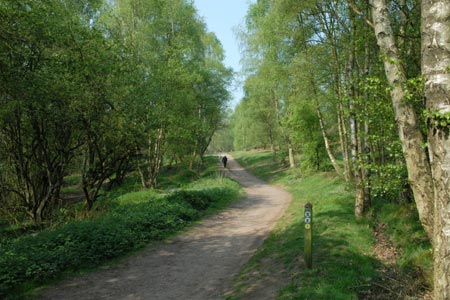
Downs Banks near Barlaston
Staffordshire Walk
County/Area - Staffordshire - Mid Staffordshire
Author - Lou Johnson
Length - 2.5 miles / 4.1 km Ascent - 250 feet / 76 metres
Time - 1 hours 30 minutes Grade - easy
Maps 

| Ordnance Survey Explorer 258 | Sheet Map | 1:25k | BUY |
| Anquet OS Explorer 258 | Digital Map | 1:25k | BUY |
| Ordnance Survey Landranger 127 | Sheet Map | 1:50k | BUY |
| Anquet OS Landranger 127 | Digital Map | 1:50k | BUY |
Walk Route Description
Click image to visit gallery of 9 images.
This is an attractive area of National Trust woodland and heath lying just to the north of Stone. You can undertake a basic low level circuit but this route includes some climbing with the added benefit of much improved views.
The start is the small car park (grid ref. SJ900365) just off Washdale Lane. Leave the car park and turn left following a broad level path. After 200 yards, take the clear path on the right by some picnic tables. This path meanders and climbs between trees eventually reaching open ground with good views away to your left. Ahead you will see the Millennium Monument and this is the next objective. Sadly someone had stolen the brass topograph when I walked this route but hopefully this will be replaced. Despite the vandalism, the view remains excellent especially towards the west and north west.
From the monument, descend on a clear path down towards the stream. During the descent you will notice a path slanting upwards to the right on the opposite hillside. This is the next objective on the route. Having reached this path, follow it uphill to reach the crest of a small ridge and a clear path.
Turn left along this path and enjoy the views to either side. The path eventually descends to the stream. Do not cross the stream, instead follow the path downstream. Cross the footbridge and turn left up the Washdale Lane. The entrance to the car park is a short way along this lane on the left.
Other walks nearby
| Walk 2842 | Sandon Park from Salt | easy | 4.6 miles |
| Walk 3531 | Cop Mere and the Offleys | easy | 7.0 miles |
| Walk 2099 | Stafford - a town centre stroll | easy | 1.5 miles |
| Walk 2443 | Tixall from St Thomas Priory near Stafford | easy | 7.0 miles |
| Walk 3591 | Derrington circular from Stafford Castle | easy | 3.6 miles |
| Walk 1752 | Churnet Valley | easy | 2.6 miles |
| Walk 1394 | Bednall & Acton Trussell from near Stafford | easy | 6.5 miles |
| Walk 1284 | Churnet Valley - Kingsley to Cheddleton | easy | 5.0 miles |
| Walk 2199 | Brocton & Walton-on-the-Hill Circular | easy | 3.5 miles |
| Walk 1802 | Shugborough Park from Milford | easy | 4.5 miles |
Recommended Books & eBooks
Walking in the Peak District - White Peak East
 Guidebook describing 42 half-day and day walks in the limestone landscapes of Derbyshire's White Peak, part of the Peak District National Park. One of two volumes, this book covers the east of the region, with potential bases including Bakewell, Eyam, Castleton, Birchover, Matlock and Wirksworth.
More information
Messaging & Social Media
Message Walking Britain and follow the latest news.

Mountain Weather
Stay safe on the mountains with detailed weather forecasts - for iOS devices or for Android devices.