Eccup Reservoir circular from Alwoodley Park
West Yorkshire Walk
County/Area - West Yorkshire - Leeds Wakefield
Author - Allan Friswell
Length - 7.5 miles / 12.2 km Ascent - 400 feet / 121 metres
Time - 4 hours 10 minutes Grade - easy/mod
Maps 

| Ordnance Survey Explorer 289 | Sheet Map | 1:25k | BUY |
| Anquet OS Explorer 289 | Digital Map | 1:25k | BUY |
| Ordnance Survey Landranger 104 | Sheet Map | 1:50k | BUY |
| Anquet OS Landranger 104 | Digital Map | 1:50k | BUY |
Walk Route Description
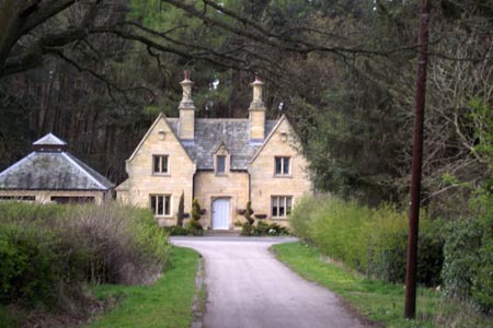
Click image to visit gallery of 6 images.
A straightfoward ramble with little climbing, but one which, given that the Leeds conurbation starts just a couple of miles down the road, is an eye-opener. Peaceful grass meadows and arable and stock fields abound; there is a delightful walk through deciduous woods, as well as the charm of Eccup reservoir; and there are the many Red Kites to be spotted.
From the A660 roundabout just SE of Bramhope take the eastbound King Road past Black Hill Quarry to the T-junction where you turn right along Arthington Road, then first left along King's Lane and keep ahead over a junction towards Alwoodley Park. Shortly after the houses begin go left along Alwoodley Lane. Park with consideration in Lakeland Drive, the third road on the left. (SE296408).
Walk back to the main road and turn left, then left again along the footpath leading down to the golden stone reservoir building, Goodrick Lodge. Follow the path to the left of the house. This delightful path leads you via a gate around an enormous field alongside the mixed conifer / deciduous Goodrick Plantation. Cross the stile in the corner where the Dales Way comes in and descend to Eccup Moor Road.
Turn right and pass through the hamlet of Eccup which takes its name from the Norse "Oak in a high place". Follow this quiet road and take a narrow track on the left (the Dales Way goes up there), ignore the cycle path on the left and reach Eccup Lane. Turn right, cross and take the path. This brings you to a wall with a stile, and the Dales Way continues via a stile on the right.
The path soon reaches a stile and bends sharp right along the field edge. It brings you to a stile above Bank Side farm. Negotiate this and the untidy farmyard, and turn right along Allums Lane (Ebor Way). To your left you can see the many arches of Arthington viaduct. This is a good place to see Red Kites of an afternoon.
At the end turn right and climb Bedlam Lane, taking a left at the T junction on to Eccup Lane and dropping to the bottom where you take the bridleway on the right. Follow this for ½ mile to where the Ebor Way and Leeds County Way cross in Stub House Plantation. Turn right along the latter, pass Stub House Farm and keep straight on, leaving the LCW. There are ever more obvious views of the village built for "Emmerdale" on the left, cricket pavilion and square and all.
The bridleway is easy to follow and brings you to an access lane where you turn left and find the footpath behind the beech hedging opposite the entrance to the water treatment works. Follow it to the end where you turn right and follow the access road round to the left, over the dam. The path starts in front of the water board house and you simply follow it around the reservoir now, eventually reaching Goodrick Lodge once again where you turn left and retrace your steps to the car.
Other walks nearby
| Walk 1380 | Bramham Park & Newton Kyme from Kiddal Bridge | easy/mod | 10.0 miles |
| Walk 2160 | Wetherby to Follifoot without a car | easy/mod | 10.3 miles |
| Walk 1800 | West of Harrogate without a car | easy/mod | 9.0 miles |
| Walk 2802 | Shipley to Ilkley via Ilkley Moor | moderate | 10.8 miles |
| Walk 1408 | Saltaire - the model village | easy | 1.5 miles |
| Walk 1572 | Swinsty Reservoir | easy | 3.0 miles |
| Walk 3114 | Haystacks, Twelve Apostles & Idol Stone of Ilkley Moor | easy/mod | 4.5 miles |
| Walk 1078 | Hampsthwaite & Ripley Park | easy | 7.5 miles |
| Walk 1952 | Five Rise Locks and the River Aire, Bingley | easy | 5.3 miles |
| Walk 2319 | Ilkley to Bingley | easy/mod | 7.0 miles |
Recommended Books & eBooks
The Dales Way
 An essential guidebook to walking the Dales Way. This picturesque 78 mile long distance route through the Yorkshire Dales between Ilkley and Bowness on Windermere is one of the gentlest multi-day walks in Britain. The route is described in both directions, visiting Grassington, Kettlewell, Buckden, Dent, Sedbergh and Staveley en route to Bowness.
More information
Messaging & Social Media
Message Walking Britain and follow the latest news.

Mountain Weather
Stay safe on the mountains with detailed weather forecasts - for iOS devices or for Android devices.