Bowcombe Down from Carisbrooke
Isle of Wight AONB Walk
Region - Isle of Wight AONB
County/Area - Isle of Wight
Author - Zelma Barnes
Length - 4.8 miles / 7.7 km Ascent - 400 feet / 121 metres
Time - 2 hours 50 minutes Grade - easy
Maps 

| Ordnance Survey Explorer OL29 | Sheet Map | 1:25k | BUY |
| Anquet OS Explorer OL29 | Digital Map | 1:25k | BUY |
| Ordnance Survey Landranger 196 | Sheet Map | 1:50k | BUY |
| Anquet OS Landranger 196 | Digital Map | 1:50k | BUY |
Walk Route Description
Click image to see photo description.
This walk starts at the High Street Car Park (Grid ref. SZ486882) in Carisbrooke. The route climbs onto Bowcombe Down from where there is a grand panorama looking north to the mainland. On the return leg the bonus is a fine view of Carisbrooke Castle and St. Mary's Church.
Leave the car park and go left up the hill with St. Mary's Church on your right. Go straight across at the mini roundabout and continue up the hill until you reach Nodgham Lane on your left, which you take. After 100 metres take the small lane on your right signed N123 Tennyson Trail to Brighstone Forest.
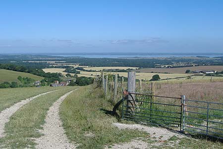
Follow this bridleway until you come to a "crossroads" (Grid ref. SZ468874) at the end of the lane you have walking along. Go straight ahead, signed N128, through this field until you reach the next gateway. To get a nice view of Newtown Creek and the mainland walk a few yards to your right here to the gate facing you (see image illustrating this walk). Turn left into a very short lane and at the end go left down the side of a field. There is a signpost here but no sign! At the bottom of the next field, go through the gate on your left into Cow Lane, signed N132 (Grid ref. SZ461868). The bottom of this lane can be overgrown with nettles in the summer so beware if you are wearing shorts!
When you reach the main road (Grid ref. SZ468869) go right for a few yards then left down into Bowcombe Farm Lane, signed N144. When you have passed the houses and farm buildings continue along the farm track, ignoring the bridleway on your left, until the track opens out into fields. Take footpath N205 across the field on your left. This field gives a lovely view of Carisbrooke Castle and St.Mary's Church tower straight in front of you. At the lane go left for a few yards then over the stile on your right, signed N104, into the water meadows to take you back to Carisbrooke. The third field can be a bit muddy in very wet weather where Lukely Brook runs up against the footpath and also at the double stile at the end of this field. A bonus is that you can often see Herons and Little Egrets in this brook.
When you reach the metalled lane go right and then left into Millers Lane. ?If you wish to walk around the Castle there are a couple of footpaths from Millers Lane which take you up to the entrance. At the end of Millers Lane bear left along by the ford and up Castle Street to Carisbrooke High Street where St Mary's Church ?bridal steps are opposite you. The burial entrance to the churchyard is up the hill and the christening steps are down the hill. Go right down the hill and the car park is on your right.
Other walks nearby
| Walk 2916 | Gatcombe and Shorwell from Carisbrooke, IOW | moderate | 10.0 miles |
| Walk 2350 | Appuldurcombe Circular | easy/mod | 5.5 miles |
| Walk 2435 | Compton Down circular | moderate | 12.5 miles |
| Walk 1751 | St Catherine's Hill & Coastal Path | moderate | 6.7 miles |
| Walk 2112 | Shanklin to Sandown | easy | 3.0 miles |
| Walk 2414 | Compton Down and Five Barrows from Compton Chine | easy/mod | 5.0 miles |
| Walk 3745 | Ventnor Downs Circular | moderate | 7.7 miles |
| Walk 2311 | The Needles & Tennyson's Monument from Freshwater Bay | easy/mod | 6.0 miles |
| Walk 1546 | Yarmouth, Freshwater and Norton from Yarmouth | easy | 5.0 miles |
| Walk 2223 | The Needles & Tennyson's Monument from Nodewell Farm | easy | 4.0 miles |
Recommended Books & eBooks
No suggestions for this area.Messaging & Social Media
Message Walking Britain and follow the latest news.

Mountain Weather
Stay safe on the mountains with detailed weather forecasts - for iOS devices or for Android devices.