Avon Dam Reservoir & White Barrows from Shipley Bridge
Dartmoor Walk
Nat Park - Dartmoor
County/Area - Devon
Author - Lou Johnson
Length - 5.5 miles / 8.9 km Ascent - 740 feet / 224 metres
Time - 3 hours 30 minutes Grade - easy/mod
Maps 

| Ordnance Survey Explorer OL20 | Sheet Map | 1:25k | BUY |
| Anquet OS Explorer OL20 | Digital Map | 1:25k | BUY |
| Ordnance Survey Explorer OL28 | Sheet Map | 1:25k | BUY |
| Anquet OS Explorer OL28 | Digital Map | 1:25k | BUY |
| Ordnance Survey Landranger 202 | Sheet Map | 1:50k | BUY |
| Anquet OS Landranger 202 | Digital Map | 1:50k | BUY |
Walk Route Description
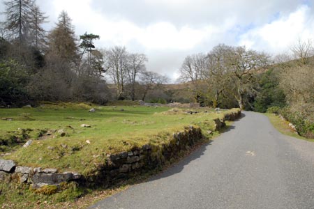
Click image to visit gallery of 12 images.
A pleasant valley following the River Avon with a gentle climb up to the shores of the Avon Dam Reservoir provide a relaxing start to what becomes a tougher walk. Climbing west beside the dam wall the route takes you across rough moorland to White Barrows (472m) and then down to the valley following an old tramway. This section from White Barrows need careful navigation especially in poor visibility.
The walk starts from the car parking area at Shipley Bridge (grid ref. SX680629). To get here you need to use the lanes (narrow in places) that lead from South Brent or the junction of the A38/A385 just to the east of the village.
After parking follow the River Avon upstream on a tarmac road. The walking is pleasant and you soon make good progress passing through deciduous woodland. Pass a small tarmac lane on the left signed to the filtration plant. Continue beside a metal gate across the road and shortly after notice the remains of Brent Moor House on your left. After a number of uses since WW2 the building was eventually demolished in 1968. Crossing a bridge the landscape becomes wilder. Continue on the tarmac road, ignoring a rough track veering off right to reach the base of the dam.
The climbing now starts and a good sense of direction is required. First bear left and follow the rough path that seems to have developed up to the top of the dam and the shore of the reservoir. Once this task has been completed, look for a path steadily climbing across the moor in a westerly direction. In places the path fades but seems to reappear, continuing to climb steadily. To help maintain the correct direction, this path goes half right from the line of the dam. If you lose the path, which is more likely as you gain height, ensure that you continue to climb. Eventually the lie of the land enables you get direct sight of the large pile of stones on top of White Barrows (grid ref. SX664651). As soon as this happens make a beeline for the top where the view is excellent.
With one difficulty over, the next task is to locate the old tramway. This is easier said than done as the path following the old tramway is hard to spot from White Barrows! A compass is useful and walking due south for about 500 metres will eventually lead to the remains of the old railway track (grid ref. S664646 ). Turn left onto the track and follow it in a large loop across Brent Moor. The remains of the railway are surprisingly intact considering the length of time it has been out of use.
Eventually the track leads to a tarmac lane (grid ref. SX677630). Turn downhill (left) onto this and walk down into the valley. Joining the outward route, turn right and very shortly after you arrive back at the parking area.
Other walks nearby
| Walk 3387 | Upper Erme Valley & Ugborough Moor | moderate | 9.3 miles |
| Walk 1657 | Huntingdon Warren & Lud Gate from Scorriton | moderate | 7.0 miles |
| Walk 3458 | Sharrah Pool from New Bridge | easy | 3.4 miles |
| Walk 3460 | Dr Blackall's Drive & Ponsworthy | easy/mod | 6.8 miles |
| Walk 3463 | Sharp Tor, Corndon Tor & Yar Tor Circular | easy/mod | 3.4 miles |
| Walk 2912 | Dartington from Totnes | easy | 2.5 miles |
| Walk 1083 | Eylesbarrow & Sheeps Tor | moderate | 8.0 miles |
| Walk 3462 | Corndon Tor & Yar Tor Circular | easy/mod | 4.3 miles |
| Walk 2016 | Cross Gate to Nuns Cross via Leather Tor | moderate | 8.0 miles |
| Walk 3671 | Nun's Cross & Peat Cot from Princetown | easy/mod | 7.0 miles |
Recommended Books & eBooks
No suggestions for this area.Messaging & Social Media
Message Walking Britain and follow the latest news.

Mountain Weather
Stay safe on the mountains with detailed weather forecasts - for iOS devices or for Android devices.